The Östliche Karwendelspitze is a mountain formed from Wetterstein limestone in the Karwendel mountains on the border between Bavaria and Tyrol. It is the highest mountain of the Northern Karwendel chain and the highest German peak in the Karwendel. It was first climbed by Hermann von Barth on 4 July 1870.
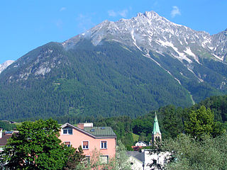
The Nordkette, also variously called the North Chain, Northern Range, rarely the Inn Valley Range or Inn Valley Chain (Inntalkette), is a range of mountains just north of the city of Innsbruck in Austria. It is the southernmost of the four great mountain chains in the Karwendel. To the west it is linked by the Erl Saddle to the Erlspitze Group, to the east via the Stempeljoch saddle to the Gleirsch-Halltal Range. To the south it is bounded by the Inn valley. Its highest summit is the Kleiner Solstein in the west of the range.

The Kleiner Solstein is a mountain, 2,637 m (AA) high, in the Nordkette in the Karwendel Alps in the Austrian state of Tyrol. Despite its name it towers above its western neighbour, the Großer Solstein by almost 100 m (330 ft) and is thus the highest summit in the Nordkette. The southern side of the Kleiner Solstein facing the Inn valley is characterised by schrofen and steep-sided cirques. To the north it plummets in a rock face up to 600 m (2,000 ft) high towards the valley of Großkristental, which runs from the Gleirsch valley in a southwesterly direction to the Erl Saddle.

The Große Solstein is a mountain, 2,541 m (AA) high, on the western corner of the Nordkette range in the Karwendel mountains near Zirl in the Austrian state of Tyrol. Its summit may be ascended on various mountain tour routes either from the Solsteinhaus or from the New Magdeburg Hut. These routes are described as not difficult but require stamina. The crossing to the higher peak of the Kleiner Solstein, despite its name the highest in the Nordkette, is described in that article.

The Hohe Warte is a mountain, 2,597 m (AA) in height, in the Karwendel range in Austria. It is located between the Kleiner Solstein to the west and the Hintere Brandjochspitze to the east, in the Nordkette in the state of Tyrol, north of the Innsbruck quarter of Kranebitten and has a prominence of at least 77 metres.
The Vordere Brandjochspitze is a peak, 2,559 m (AA) high, in the Nordkette in the Karwendel range and is one of its highest and most striking peaks. In its immediate vicinity to the north-northwest is its sister summit, the Hintere Brandjochspitze, which is about 40 metres higher. To the south a prominent arête runs over to the Brandjochkreuz and the Achselkopf and down to the Innsbruck quarter of Hötting. To the east, the main ridge of the Nordkette runs over to Frau Hitt.

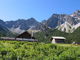
The Reither Spitze is a mountain in the Karwendel in the Austrian federal state of Tyrol that, thanks to its location at the southwestern end of the Erlspitze Group, is particularly well known for its great views of the surrounding area from its summit. Its name is derived the village of Reith bei Seefeld, which lies at its southwestern foot.

The Härmelekopf is a mountain northeast of Seefeld in Tirol in the Karwendel Alps in the Austrian state of Tyrol. It is 2,224 metres high.

The Kuhljochspitze is a mountain, 2,297 m (AA) high, in the Erlspitze Group in the Karwendel Alps in Austria.

The Kaltwasserkarspitze is a mountain in the Hinterautal-Vomper Chain and, at 2,733 m (AA) m, is the fourth highest peak in the Karwendel mountains in Austria after the Birkkarspitze, Middle and Eastern Ödkarspitze. The Kaltwasserkarspitze is the eastern neighbour of the Birkkarspitze, its rugged summit dropping in a steep rock face to the valley of Kleiner Ahornboden. A long arête heads south from the mountain, on which are the Sägezähne and the Großer Heißenkopf and which separates the Östliche Birkkar from the Raukarl.

The Ödkarspitzen are three peaks in the Karwendel mountains in the Austrian state of Tyrol in the Hinterautal-Vomper Chain between the ultra-prominent mountain of Birkkarspitze in the east and the Marxenkarspitze in the west. The highest of the summits is the Middle Ödkarspitze with a height of 2,745 m (AA). The Western Ödkarspitze is 2,712 m (AA) high and the Eastern Ödkarspitze is 2,738 m (AA) high.

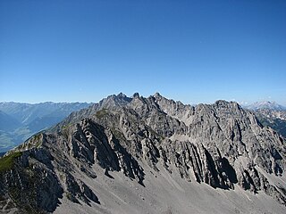
The Hinterautal-Vomper Chain, also called the main chain of the Karwendel (Karwendelhauptkette), is the longest mountain chain in the Karwendel Alps in Austria. It has numerous peaks that reach heights of 2,500 m, including the highest summit of the Karwendel, the Birkkarspitze, and its neighbour, the three Ödkarspitzen. While long ridges radiate south and north from the western part of the main chain, with typical Karwendel cirques nestling between them, the eastern part of the chain has an almost 1,000 m high, solid rock face on the northern side, which is most striking at the Laliderer Wand. The main chain is divided into the Hinterautal chain (Hinterautalkette) in the west and the Vomper Chain (Vomperkette) in the east and runs through the Karwendel Alps from Scharnitz in the west to the village of Vomp in the east.

The Großer Bettelwurf is a mountain, 2,726 m (AA), and thus the highest peak in the Gleirsch-Halltal Chain in the Karwendel mountains of Tyrol. It is also the fourth highest summit in the Karwendel. The neighbouring Kleiner Bettelwurf reaches a height of 2,650 m (AA).

The Gleirsch-Halltal Chain or Gleirsch-Halltal Range is a mountain chain in the Karwendel in the Northern Limestone Alps. It follows to the south of the Hinterautal-Vomper Chain, the longest mountain chain in the Karwendel, and is almost as big as it. South of the Stempeljochspitze on the other side of the Stempeljoch saddle it is joined to the Nordkette. The name of the range is derived from the two valleys: the Gleirschtal to the west and southwest and the Halltal to the southeast.

The Schaufelspitze is a mountain, 2,306 m (AA) in the Sonnjoch Group in the eastern Karwendel between Sonnjoch and the Bettlerkarspitze.

The Northern Karwendel Chain is the northernmost of the four great, largely parallel mountain chains in the Karwendel in the Alps. It is made from very pure Wetterstein limestone, which has its heart in the Karwendel and runs for a total length of c. 18 kilometres from Scharnitz in the northeast via Mittenwald to the Wörner, where it turns sharply east, until it finally ends west of the Johannestal valley. It has 25 main summits with an average height of 2,400 m. The highest peak is the Eastern Karwendelspitze. The boundary between Germany and Austria runs along the crest from the Brunnensteinspitze in the west to the Eastern Karwendelspitze in the east. The northwestern side is Bavarian, the southeastern flank is Tyrolean. The Northern Karwendel Chain should not be confused with the southernmost chain of the Karwendel, the Inn Valley Chain, which is known colloquially as the Nordkette or "North Chain" due to its location north of the city of Innsbruck.