Frelighsburg

Last updated

Frelighsburg
Frelighsburg-moulin de Frelich.jpg
The Freligh Mill on Pike River
Blason ville ca Frelighsburg (Quebec).svg
Frelighsburg Quebec location diagram.PNG
Location within Brome-Missisquoi RCM.
Canada Southern Quebec location map.png
Red pog.svg
Frelighsburg
Location in southern Quebec.
Coordinates: 45°03′N72°50′W / 45.050°N 72.833°W / 45.050; -72.833 [1]
Country Canada
Province Quebec
Region Estrie
RCM Brome-Missisquoi
ConstitutedSeptember 28, 1985
Government
[2]
  MayorLucie Dagenais
   Federal riding Brome—Missisquoi
   Prov. riding Brome-Missisquoi
Area
  Total
124.60 km2 (48.11 sq mi)
  Land123.31 km2 (47.61 sq mi)
Population
 (2021) [3]
  Total
1,123
  Density9.1/km2 (24/sq mi)
  Pop 2016-2021
Increase2.svg 1.1%
  Dwellings
622
Time zone UTC−5 (EST)
  Summer (DST) UTC−4 (EDT)
Postal code(s)
Area codes 450 and 579
HighwaysQc213.svg R-213
Qc237.svg R-237
Website https://frelighsburg.ca/

Frelighsburg is a municipality in the Estrie region of southern Quebec, Canada, on the border with Vermont. It is at the foot of Mount Pinnacle, part of the Appalachian Mountains.

Contents

Administratively, it is within the Brome-Missisquoi Regional County Municipality, in Estrie. Its population, as of the Canada 2021 Census, was 1,123.

History

Saint-Francois d'Assise Church Frelighsburg-Eglise St-Francois Assise.jpg
Saint-François d'Assise Church

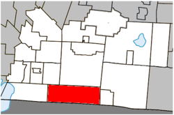
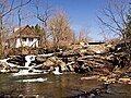
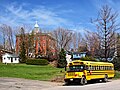
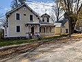
The land that is now Frelighsburg was originally inhabited by the Abenaki people. It was established as a colony in the late 1790s by American Loyalists, including pioneer Abram Freligh, a physician of German origin who lived in Clinton, New York. The sawmill built by his son in 1839, and several other buildings from the 19th century are considered historical monuments. Prior to being named Frelighsburgh, it was named Conroy's Mills, named after another mill owner, and Slab City because of the large quantities of sawdust and slabs (slang for bark) in the area. [1]

Geography

Frelighsburg is located less than 4 kilometres (2.5 mi) from the Canada–US border with Vermont, nestled in a valley of orchards, crossed by the Pike River and at the foot of Mount Pinnacle.

Demographics

Infrastructure

Frelighsburg is crossed by the Route 237. Route 213 starts in Frelighsburgh.

See also

References

  1. 1 2 http://www.toponymie.gouv.qc.ca/ct/ToposWeb/fiche.aspx?no_seq=148987 Frelighsburg - Commission de toponymie du Québec
  2. 1 2 "Répertoire des municipalités: Geographic code 46010". www.mamh.gouv.qc.ca (in French). Ministère des Affaires municipales et de l'Habitation.
  3. 1 2 2021 Statistics Canada Census Profile: Frelighsburg, Quebec
  4. Statistics Canada: 1996, 2001, 2006, 2011, 2016, 2021 census
  5. 2021 Statistics Canada Community Profile: Frelighsburg, Quebec