Related Research Articles

The Ross Sea is a deep bay of the Southern Ocean in Antarctica, between Victoria Land and Marie Byrd Land and within the Ross Embayment, and is the southernmost sea on Earth. It derives its name from the British explorer James Clark Ross who visited this area in 1841. To the west of the sea lies Ross Island and Victoria Land, to the east Roosevelt Island and Edward VII Peninsula in Marie Byrd Land, while the southernmost part is covered by the Ross Ice Shelf, and is about 200 miles (320 km) from the South Pole. Its boundaries and area have been defined by the New Zealand National Institute of Water and Atmospheric Research as having an area of 637,000 square kilometres (246,000 sq mi).
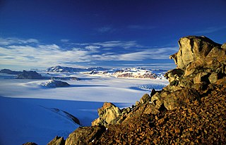
The Transantarctic Mountains comprise a mountain range of uplifted rock in Antarctica which extends, with some interruptions, across the continent from Cape Adare in northern Victoria Land to Coats Land. These mountains divide East Antarctica and West Antarctica. They include a number of separately named mountain groups, which are often again subdivided into smaller ranges.

The geology of Antarctica covers the geological development of the continent through the Archean, Proterozoic and Phanerozoic eons.

The Hanson Formation is a geologic formation on Mount Kirkpatrick and north Victoria Land, Antarctica. It is one of the two major dinosaur-bearing rock groups found on Antarctica to date; the other is the Snow Hill Island Formation and related formations from the Late Cretaceous of the Antarctic Peninsula. The formation has yielded some Mesozoic specimens, but most of it is as yet unexcavated. Part of the Victoria Group of the Transantarctic Mountains, it lies below the Prebble Formation and above the Falla Formation. The formation includes material from volcanic activity linked to the Karoo-Ferar eruptions of the Lower Jurassic. The climate of the zone was similar to that of modern southern Chile, humid, with a temperature interval of 17–18 degrees. The Hanson Formation is correlated with the Section Peak Formation of the Eisenhower Range and Deep Freeze Range, as well as volcanic deposits on the Convoy Range and Ricker Hills of southern Victoria Land. Recent work has successfully correlated the Upper Section Peak Formation, as well unnamed deposits in Convoy Range and Ricker Hills with the Lower Hanson, all likely of Sinemurian age and connected by layers of silicic ash, while the upper section has been found to be Pliensbachian, and correlated with a greater volcanic pulse, marked by massive ash inputs.
The Fremouw Formation is a Triassic-age rock formation in the Transantarctic Mountains of Antarctica. It contains the oldest known fossils of tetrapods from Antarctica, including synapsids, reptiles and amphibians. Fossilized trees have also been found. The formation's beds were deposited along the banks of rivers and on floodplains. During the Triassic, the area would have been a riparian forest at 70–75°S latitude.
Mount Achernar is a peak forming the northeast end of the MacAlpine Hills, on the south side of Law Glacier. Named by the New Zealand Geological Survey Antarctic Expedition (NZGSAE) (1961–62) after the star Achernar used in fixing the survey baseline.Antacrtica
The Beacon Supergroup is a geological formation exposed in Antarctica and deposited from the Devonian to the Triassic. The unit was originally described as either a formation or sandstone, and upgraded to group and supergroup as time passed. It contains a sandy member known as the Beacon Heights Orthoquartzite.
Carapace Nunatak is a prominent isolated nunatak, the most westerly near the head of Mackay Glacier in Victoria Land, standing 8 nautical miles (15 km) southwest of Mount Brooke where it is visible for a considerable distance from many directions. It was so named by the New Zealand party of the Commonwealth Trans-Antarctic Expedition (1956–1958) because of the fossil carapaces of small crustaceans found in the exposed rocks.
Coalsack Bluff is a small rock bluff standing at the northern limits of Walcott Neve, 6 nautical miles (11 km) west-southwest of Bauhs Nunatak. It was so named by the New Zealand Geological Survey Antarctic Expedition (1961–62) because of the coal seams found running through the bluff.
Mount Weller is a peak (2,420 m) rising above the west side of Beacon Valley, 4 nautical miles (7 km) southwest of Pyramid Mountain, in Quartermain Mountains, Victoria Land, Antarctica. It is also 90 miles (140 km) due west of McMurdo Station. The name appears to be first used on a 1961 New Zealand Lands and Survey Department map compiled from New Zealand field surveys, 1957–60, and U.S. Navy aerial photographs of that period. Presumably named after William J. Weller, Royal Navy, a seaman of the ship RSS Discovery. In November 1903, Weller and Thomas Kennar accompanied Hartley T. Ferrar in the first geological reconnaissance of Quartermain Mountains.
Turbidite Hill is a low nunatak that lies four nautical miles (7 km) east of Laird Plateau on the north side of Olson Neve in Antarctica. It was mapped by the Holyoake, Cobham and Queen Elizabeth Ranges party of the New Zealand Geological Survey Antarctic Expedition (NZGSAE) (1964–65). It was named after sedimentary features, called turbidites, which were reportedly found in sedimentary rocks of the Beacon Supergroup which forms the summit of this hill.
Epidote Peak is a prominent rock peak just north of the mouth of Held Glacier, lying along the west side of Shackleton Glacier in the Queen Maud Mountains of Antarctica. The Texas Tech Shackleton Glacier Expedition, 1964–65, named it for the abundance of the mineral epidote. Local concentrations of this mineral gives the peak a spotted appearance. The name was approved by US-ACAN in 1966.
Gordon Valley is a small valley, the western half of which is occupied by a lobe of ice from Walcott Neve, lying west of Mount Falla in the Queen Alexandra Range, Antarctica. It was named by the Advisory Committee on Antarctic Names after Mark A. Gordon, a United States Antarctic Research Program aurora scientist at Hallett Station, 1959.
Graphite Peak is a peak, 3,260 metres (10,700 ft) high, standing at the northeast end of a ridge running 3 nautical miles (6 km) northeast from Mount Clarke, just south of the head of Falkenhof Glacier in Antarctica. It was so named by the New Zealand Geological Survey Antarctic Expedition (1961–62) because of the graphite found on the peak.
Thrinaxodon Col is a rock col 2 nautical miles (3.7 km) southeast of Rougier Hill. The col is along the ridge that trends southward from Rougier Hill in the Cumulus Hills, Queen Maud Mountains. The name was proposed to Advisory Committee on Antarctic Names (US-ACAN) in 1971 by geologist David H. Elliot of the Ohio State University Institute of Polar Studies.

Peter John Barrett is a New Zealand geologist who came to prominence after discovering the first tetrapod fossils in Antarctica in 1967.
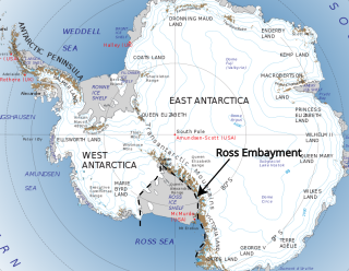
The Ross Embayment is a large region of Antarctica, comprising the Ross Ice Shelf and the Ross Sea, that lies between East and West Antarctica.

The Mawson Formation is a geological formation in Antarctica, dating to roughly between 182 and 177 million years ago and covering the Toarcian stages of the Jurassic Period in the Mesozoic Era. Vertebrate remains are known from the formation. The Mawson Formation is the South Victoria Land equivalent of the Karoo Large Igneous Province in South Africa, as well the Lonco Trapial Formation and the Cañadón Asfalto Formation of Argentina. The Volcanic material was likely sourced from the Antarctic Peninsula´s Ellsworth Land Volcanic Group.

The geology of the Ellsworth Mountains, Antarctica, is a rock record of continuous deposition that occurred from the Cambrian to the Permian periods, with basic igneous volcanism and uplift occurring during the Middle to Late Cambrian epochs, deformation occurring in the Late Permian period or early Mesozoic era, and glacier formation occurring in the Cretaceous period and Cenozoic era. The Ellsworth Mountains are located within West Antarctica at 79°S, 85°W. In general, it is made up of mostly rugged and angular peaks such as the Vinson Massif, the highest mountain in Antarctica.
References
- ↑ "Fremouw Peak". Geographic Names Information System . United States Geological Survey, United States Department of the Interior . Retrieved 2023-11-23.
- ↑ Stewart, J., 2011. Antarctica: An Encyclopedia, 2nd ed. Jefferson, North Carolina and London, McFarland & Company, Inc. 1771 pp. ISBN 978-0-7864-3590-6
- ↑ Barrett, P.J., 1969, Stratigraphy and petrology of the mainly fluviatile Permian and Triassic Beacon rocks, Beardmore Glacier area, Antarctica.Ohio State University Institute of Polar Studies Report 34, pp1-132 .
- ↑ Barrett, P.J., Elliot, D.H., Lindsay, J.F., 1986. The Beacon Supergroup (Devonian–Triassic) and Ferrar Group (Jurassic) in the Beardmore Glacier area, Antarctica. In: Turner, M.D., and Splettstoesser, J.F., eds, pp. 339-428, Geology of the central Transantarctic Mountains.American Geophysical Research Series, 36. Washington, DC, American Geophysical Union, 453 pp. ISBN 978-1118664797
- ↑ Taylor, E.L., and Taylor, T.N., 1990. Structurally Preserved Permian and Triassic Floras from Antarctica. In: Taylor, T.N., and Taylor, E.L., eds, pp. 149-164, Antarctic Paleobiology, its Role in the Reconstruction of Gondwana, New York, New York, Springer-Verlag, 216 pp. ISBN 978-1-4612-3238-4
- ↑ Bomfleur, B., Schneider, J.W., Schöner, R., Viereck-Götte, L. and Kerp, H., 2011. Fossil sites in the continental Victoria and Ferrar groups (Triassic-Jurassic) of north Victoria Land, Antarctica.Polarforschung, 80(2), pp.88-99.
| | This Shackleton Coast location article is a stub. You can help Wikipedia by expanding it. |