
Gloucestershire is a county in South West England. The county comprises part of the Cotswold Hills, part of the flat fertile valley of the River Severn and the entire Forest of Dean.

The River Severn, at 220 miles (354 km) long, is the longest river in Great Britain. It is also the river with the most voluminous flow of water by far in all of England and Wales, with an average flow rate of 107 m3/s (3,800 cu ft/s) at Apperley, Gloucestershire. It rises in the Cambrian Mountains in mid Wales, at an altitude of 2,001 feet (610 m), on the Plynlimon massif, which lies close to the Ceredigion/Powys border near Llanidloes. The river then flows through Shropshire, Worcestershire and Gloucestershire. The county towns of Shrewsbury and Gloucester and the City of Worcester lie on its course.

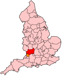
South Gloucestershire is a unitary authority area in the ceremonial county of Gloucestershire, South West England. Towns in the area include Yate, Chipping Sodbury, Thornbury, Filton, Patchway and Bradley Stoke, the latter three forming part of the northern Bristol suburbs. The unitary authority also covers many outlying villages and hamlets. The southern part of its area falls within the Greater Bristol urban area surrounding the city of Bristol.

Frampton on Severn is a village and civil parish in Gloucestershire, England. The population is 1,432.

Newnham or Newnham on Severn is a village in west Gloucestershire, England. It lies in the Royal Forest of Dean, on the west bank of the River Severn, approximately 10 miles south-west of Gloucester and three miles southeast of Cinderford. It is on the A48 road between Gloucester and Chepstow, Monmouthshire, Wales. The village has a parish council.

Quedgeley is a suburban town of Gloucester, located 3.5 miles (5.6 km) southwest of the city centre, in the county of Gloucestershire, England. A thin strip of land between the Severn and the Gloucester Ship Canal occupies the west, and the south-eastern part of the town is Kingsway Village, directly to the north of which is Tuffley.

Arlingham is a village and civil parish in the Stroud District of Gloucestershire, England. The 2001 Census recorded a parish population of 410, increasing to 459 at the 2011 census. The parish contains the hamlets of Milton End, Overton and Priding. The next parish to the east is Fretherne with Saul.

Westbury-on-Severn is a rural village in England that is the centre of the large, rural parish, also called Westbury-on-Severn.
Stroud and Thornbury was a county constituency represented in the House of Commons of the Parliament of the United Kingdom. It elected one Member of Parliament (MP) by the first past the post system of election.
Gloucestershire is one of the most geologically and scenically diverse counties in England, with rocks from the Precambrian through to the Jurassic represented. These varying rock-types are responsible for the three major areas of the county, each with its own distinctive scenery and land-use - the Forest of Dean in the west, bordering Wales, the Cotswolds in the east, and in between, the Severn Vale.
The Stroudwater Navigation is a canal in Gloucestershire, England which linked Stroud to the River Severn. It was authorised in 1776, although part had already been built, as the proprietors believed that an Act of Parliament obtained in 1730 gave them the necessary powers. Opened in 1779, it was a commercial success, its main cargo being coal. It was 8 miles (13 km) in length and had a rise of 102 ft 5 in (31.22 m) through 12 locks. Following the opening of the Thames and Severn Canal in 1789, it formed part of a through route from Bristol to London, although much of its trade vanished when the Kennet and Avon Canal provided a more direct route in 1810. Despite competition from the railways, the canal continued to pay dividends to shareholders until 1922, and was not finally abandoned until 1954.

Saul is a village and former civil parish, now in the parish of Fretherne with Saul, in the Stroud district, in the county of Gloucestershire, England. In 1881 the parish had a population of 597. On 24 March 1884 the parish was abolished to form Fretherne with Saul, part also went to Moreton Valance and Standish.

Fretherne is a small village and former civil parish, now in the parish of Fretherne with Saul, in the Stroud district, in Gloucestershire, England, situated between the larger villages of Frampton-on-Severn and Arlingham. In 1881 the parish had a population of 239. In the Domesday Book of 1086 it is recorded as held by Turstin FitzRolf. The village name probably originates from O.E. 'Frithorne,' meaning 'Freo's thorn.'

Framilode is a village on the banks of the River Severn in Gloucestershire, England, in the parish of Fretherne with Saul. It consists of two settlements: the larger, Framilode, is at the mouth of the River Frome. The smaller settlement, Framilode Passage, lies about 0.5 mile downstream.
Fretherne Court was a handsome residential sporting mansion with picturesque grounds and deer park estate of some 676 acres, situated in the Severn Vale between the Gloucester and Sharpness Canal and the River Severn, in Fretherne, Gloucestershire. It was owned by the Darell family who were Baronets of Richmond Hill.

Gloucestershire Victoria County History is an encyclopaedic history of the county of Gloucestershire in England. It forms part of the overall Victoria County History of England founded in 1899 in honour of Queen Victoria. With twelve volumes published in the series A History of the County of Gloucestershire, the Gloucestershire Victoria County History is about halfway through its history of all the parishes in the county. Ten volumes have been published to date, and a further four volumes are in preparation.

Whitstone was an ancient hundred of Gloucestershire, England. From the 13th century it comprised two adjacent divisions, which included the ancient parishes of:

Epney is a small village on the River Severn. It is 8 miles (13 km) South-West of Gloucester, Gloucestershire, England within the parish of Longney and Epney. It is between Longney and Upper Framilode. The village has a pub called The Anchor Inn. The population of the Longney and Epney parish is 285 (2011).

