Galbraith, Iowa | |
|---|---|
 Galbraith  Galbraith | |
| Coordinates: 42°58′50″N94°09′33″W / 42.98056°N 94.15917°W | |
| Country | United States |
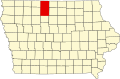
| State | Iowa |
| County | Kossuth |
| Township | Sherman |
| Elevation | 1,158 ft (353 m) |
| Time zone | UTC-6 (Central (CST)) |
| • Summer (DST) | UTC-5 (CDT) |
| Area code | 515 |
| GNIS feature ID | 464552 [1] |
Galbraith is an unincorporated community in Kossuth County, in the U.S. state of Iowa. [1]