St. Benedict, Iowa | |
|---|---|
 St. Benedict  St. Benedict | |
| Coordinates: 43°02′38″N94°03′39″W / 43.04389°N 94.06083°W [1] | |
| Country | USA |
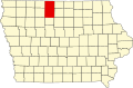
| State | Iowa |
| County | Kossuth |
| Township | Prairie |
| Area | |
• Total | 0.77 sq mi (1.99 km2) |
| • Land | 0.77 sq mi (1.99 km2) |
| • Water | 0.00 sq mi (0.00 km2) |
| Elevation | 1,266 ft (386 m) |
| Population (2020) | |
• Total | 31 |
| • Density | 40.42/sq mi (15.60/km2) |
| Time zone | UTC-6 (Central (CST)) |
| • Summer (DST) | UTC-5 (CDT) |
| Area code | 515 |
| FIPS code | 19-69825 |
| GNIS feature ID | 2585485 [1] |
St. Benedict or Saint Benedict [1] is an unincorporated community and census-designated place (CDP) in Prairie Township, Kossuth County, Iowa, United States. As of the 2020 census it had a population of 31.