The Rhinogydd are a range of mountains located east of Harlech in North Wales. The name Rhinogydd derives from the names of two of the more famous peaks, Rhinog Fawr and Rhinog Fach, although the greatest elevation in the range is reached by Y Llethr, 756 m.

Aran Fawddwy is a mountain in southern Snowdonia, Wales, United Kingdom. It is the only peak in Wales outside North Snowdonia above 900m, and higher than anywhere in Great Britain outside Northern Snowdonia, the Scottish Highlands and the Lake District. The nearest urban centres to the mountain are Dinas Mawddwy to the south, Llanymawddwy to the southeast, Llanuwchllyn on the shores of Bala Lake to the north, and Rhydymain to the west. The nearest settlements with around 2,000 people are Bala and Dolgellau. On the eastern slopes of Aran Fawddwy is the small lake named Creiglyn Dyfi, the source of the River Dyfi. Its sister peak is Aran Benllyn at 885 metres (2,904 ft). There is also a middle peak- Erw y Ddafad-ddu.

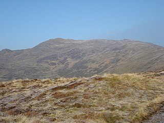
Arenig Fawr is a mountain in Snowdonia, North Wales, close to Llyn Celyn reservoir, alongside the A4212 between Trawsfynydd and Bala.

Cadair Bronwen is a mountain in North Wales and forms part of the Berwyn range. To the south are the higher Berwyn summits, including Cadair Berwyn. To the north lies Moel yr Henfaes and Moel Fferna, which top the north end of the Berwyn range. Cadair Bronwen used to be accompanied by a Nuttall top, Cadair Bronwen North-East Top, 700 m (2297 ft). This top was deleted in 2007 after re-surveying.
Moel yr Ewig is a top of Cadair Berwyn in north east Wales. It lies on ridge heading south from Cadair Berwyn's summit. The summits of Godor and Godor North Top are to be found further down the ridge.

Aran Benllyn is a subsidiary summit of Aran Fawddwy in southern Snowdonia, North Wales, Wales, United Kingdom. It is the second highest peak in the Aran mountain range.
Craig Cwm Amarch is not synonymous with Craig y Cau but names the headwall of Cwm Amarch on Cadair Idris in the Snowdonia National Park, in Gwynedd, north-west Wales.

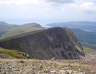
Mynydd Moel is the second highest summit of Cadair Idris in the Snowdonia National Park, in Gwynedd, northwest Wales. It lies to the east of Cadair Idris and is often climbed as a horseshoe along with Craig Cwm Amarch and Cadair Idris.
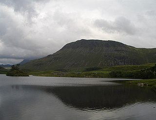
Tyrrau Mawr or Craig-las is a subsidiary summit of Cadair Idris in the Snowdonia National Park, in Gwynedd, northwest Wales. It lies to the west of Cyfrwy, and can be climbed by taking a west bearing from the Pony Path at Rhiw Gwredydd. Its north face is a crag, known as Craig-las. Below the crags lies Llyn Cregennen with its small island. The reflection of Craig-las from this lake is one of the famous images associated with Snowdonia.
Cyfrwy is a subsidiary summit of Cadair Idris in the Snowdonia National Park, in Gwynedd, northwest Wales. It lies to the west of Cadair Idris and is often climbed with Cadair Idris by taking the Pony Path.

Waun-oer is a mountain in Snowdonia, North Wales, situated approximately four miles to the south-west of Aran Fawddwy. It is one of the peaks in the Dyfi hills, a subgroup of the Cadair Idris group. It is a top of Maesglase and the summit consists of a trig point that crowns an uneven grassy plateau. It is connected to Cribin Fawr to the east. To the north lies Cadair Idris, while Tarren y Gesail lies to the west.
Cribin Fawr is a mountain in Snowdonia, North Wales, situated approximately four miles to the south-west of Aran Fawddwy. It is one of the peaks in the Dyfi hills, a subgroup of the Cadair Idris group. It is a top of Maesglase, connected to its parent peak by the Craig Portas ridge. The top of Cribin Fawr is a large open plateau of peat bog. To the west is Waun-oer, to the north Cadair Idris, to the south Maesglase and Glasgwm to the east.

Craig-y-llyn is a subsidiary summit of Cadair Idris in the Snowdonia National Park, in Gwynedd, northwest Wales. It lies at the western end of the long Cadair Idris ridge. Its north-facing cwm houses the small glacial lake, Llyn Cyri. The southern flanks have gentle slopes, while the northern are very steep and contain broken crags.
Cadair Fawr is a hill in the northern corner of the county borough of Rhondda Cynon Taf, Wales. It lies within the Brecon Beacons National Park and Fforest Fawr Geopark. The 485m high summit at OS grid ref SN 978123 is marked by a trig point. Cadair Fawr is the highest point of a broad ridge known as Cefn Cadlan which forms the northern edge of Cwm Cadlan, a valley which itself runs east-northeastwards from the village of Penderyn. The name Cadair Fawr signifies the 'big chair' whilst Cefn Cadlan signifies the 'ridge of the battlefield'.

Moel Emoel is a hill within the Snowdonia National Park in Gwynedd, North Wales.
Graig Goch is a 586m high hill in the Gwynedd area in Wales and lying within Snowdonia National Park. The hill falls within the communities of Llanfihangel-y-Pennant and Corris, the summit being located in the former. The hill takes the form of a NE-SW aligned ridge with a broad top which rise to subsidiary tops either side of the main summit. These are the 540m+ top of Mynydd Cedris and the 504m top of Mynydd Rugog. The hill’s most notable feature is the large cliff which stretches the length of its northwestern face overlooking Tal-y-llyn, in part a major rock-slope failure.

Pen Ty-Nant is a hill within the Snowdonia National Park in Gwynedd, North Wales.