Gaura, Jamo

Last updated

Gaura
Village
Jamo block map.png
Map showing Gaura (#052) in Jamo CD block
India Uttar Pradesh location map.svg
Red pog.svg
Gaura
Location in Uttar Pradesh, India
Coordinates: 26°24′03″N81°40′33″E / 26.400771°N 81.675882°E / 26.400771; 81.675882 [1]
CountryFlag of India.svg  India
State Uttar Pradesh
Division Faizabad division
District Amethi
Area
[2]
  Total4.887 km2 (1.887 sq mi)
Population
 (2011) [2]
  Total4,349
  Density890/km2 (2,300/sq mi)
Languages
  Official Hindi, Urdu
Time zone UTC+5:30 (IST)

Gaura is a village in Jamo block of Amethi district, Uttar Pradesh, India. [2] The namesake of the historical pargana of Gaura Jamun, Gaura consists of a main site called Gaura khas in the northeast surrounded by several smaller hamlets. [3] The village lands are fertile and contain many orchard groves. [3] In the east-central part there is a large jhil which provides a convenient source of irrigation but also sometimes overflows and floods the surrounding fields. [3] Gaura is located just north of Jamo on the Gauriganj-Jagdishpur road, and another road also leads off to Musafirkhana. [3]

As of 2011, Gaura has a population of 4,349 people, in 700 households. [2] It has 3 primary schools and a family welfare centre and it does not host a regular market or weekly haat. [2] It serves as the seat of a nyaya panchayat which also includes 6 other villages. [4]

History

At the turn of the 20th century, Gaura was described as a fairly large but otherwise rather insignificant village that belonged to the taluqdari estate of Katari. [3] It had a primary school, and an area of high nazul land indicated that there also used to be a fort here. [3] As of 1901, Gaura's population was 1,448 people, of which the majority were Ahirs and also including a Muslim minority of 131. [3]

The 1951 census recorded Gaura as comprising 17 hamlets, with a total population of 1,731 people (824 male and 907 female), in 368 households and 366 physical houses. [5] The area of the village was given as 1,282 acres. [5] 146 residents were literate, 126 male and 20 female. [5] The village was listed as belonging to the pargana of Gaura Jamo and the thana of Jagdishpur. [5] The village had a district board-run primary school with 177 students in attendance as of 1 January 1951. [5]

The 1961 census recorded Gaura as comprising 22 hamlets, with a total population of 1,770 people (889 male and 881 female), in 381 households and 356 physical houses. [6] The area of the village was given as 1,282 acres and it had a post office at that point. [6]

The 1981 census recorded Gaura as having a population of 2,557 people, in 465 households, and having an area of 518.83 hectares. [7] The main staple foods were listed as wheat and rice. [7]

The 1991 census recorded Gaura as having a total population of 2,795 people (1,435 male and 1,360 female), in 523 households and 515 physical houses. [4] The area of the village was listed as 490.00 hectares. [4] Members of the 0-6 age group numbered 556, or 20% of the total; this group was 53% male (294) and 47% female (262). [4] Members of scheduled castes numbered 430, or 15% of the village's total population, while no members of scheduled tribes were recorded. [4] The literacy rate of the village was 32% (579 men and 148 women, counting only people age 7 and up). [4] 837 people were classified as main workers (687 men and 150 women), while 145 people were classified as marginal workers (5 men and 140 women); the remaining 1,813 residents were non-workers. [4] The breakdown of main workers by employment category was as follows: 392 cultivators (i.e. people who owned or leased their own land); 256 agricultural labourers (i.e. people who worked someone else's land in return for payment); 12 workers in livestock, forestry, fishing, hunting, plantations, orchards, etc.; 0 in mining and quarrying; 45 household industry workers; 4 workers employed in other manufacturing, processing, service, and repair roles; 0 construction workers; 77 employed in trade and commerce; 8 employed in transport, storage, and communications; and 43 in other services. [4]

Related Research Articles

<span class="mw-page-title-main">Gairikpur</span> Village in Uttar Pradesh, India

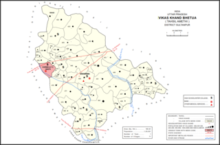
Gairikpur is a village in Bhetua block of Amethi district in Uttar Pradesh, India. As of 2011, its population is 1,754 people, in 275 households. It has one primary school and no healthcare facilities and does not host a permanent market or weekly haat. It serves as the headquarters of a nyaya panchayat that also includes 15 other villages.

<span class="mw-page-title-main">Jagdishpur, Dih, Raebareli</span> Village in Uttar Pradesh, India

Jagdishpur is a village in Dih block of Rae Bareli district, Uttar Pradesh, India. It is located 21 km from Raebareli, the district headquarters. As of 2011, it has a population of 4,538 people, in 840 households. It belongs to the nyaya panchayat of Dih.

<span class="mw-page-title-main">Garwa</span> Village in Uttar Pradesh, India

Garwa is a village in Dih block of Rae Bareli district, Uttar Pradesh, India. It is located 18 km from Raebareli, the district headquarters. As of 2011, it has a population of 1,485 people, in 294 households. It has one primary school and no healthcare facilities, and it does not host a permanent market or weekly haat. It belongs to the nyaya panchayat of Tekari Dandu.

<span class="mw-page-title-main">Nisgar</span> Village in Uttar Pradesh, India

Nisgar is a village in Sareni block of Rae Bareli district, Uttar Pradesh, India. It is located on the bank of the Ganges, 23 km from the tehsil headquarters at Lalganj. Nisgar is mentioned in the late 16th-century Ain-i-Akbari as the seat of a mahal in the sarkar of Lucknow. It was later merged into the pargana of Sareni under the Nawabs of Awadh in the 1700s.

<span class="mw-page-title-main">Singhaur Tara</span> Village in Uttar Pradesh, India

Singhaur Tara is a village in Sareni block of Rae Bareli district, Uttar Pradesh, India. It is located on the bank of the Ganges, 18 km from the tehsil headquarters at Lalganj. Singhaur Tara is probably identical with the mahal called "Tara Singhaur" Ain-i-Akbari in the late 16th century. This mahal was in the sarkar of Lucknow. It was later merged into the pargana of Sareni under the Nawabs of Awadh in the 1700s.

<span class="mw-page-title-main">Gaimau</span> Village in Uttar Pradesh, India

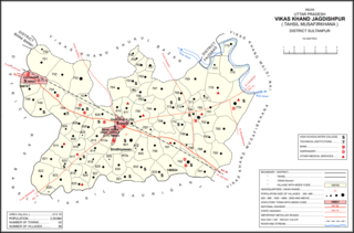
Gaimau is a village in Jagdishpur block of Sultanpur district, Uttar Pradesh, India. It is located 50 km from Sultanpur, the district headquarters. As of 2011, it has a population of 1,617 people, in 255 households. It has one primary school and no healthcare facilities and does not host a permanent market or weekly haat. It belongs to the nyaya panchayat of Harimau.

<span class="mw-page-title-main">Muradabad, Sultanpur</span> Village in Uttar Pradesh, India

Muradabad is a village in Akhand Nagar block of Kadipur tehsil in Sultanpur district, Uttar Pradesh, India. As of 2011, it has a population of 1,543 people, in 238 households. It has one primary school and no healthcare facilities and it hosts both a regular market and a weekly haat. It belongs to the nyaya panchayat of Sajampur.

<span class="mw-page-title-main">Karai, Sultanpur</span> Village in Uttar Pradesh, India

Karai is a village in Akhand Nagar block of Kadipur tehsil in Sultanpur district, Uttar Pradesh, India. As of 2011, it has a population of 1,399 people, in 196 households. It has one primary school and no healthcare facilities and it does not host a regular market or a weekly haat. It belongs to the nyaya panchayat of Sajampur.

<span class="mw-page-title-main">Raipur, Akhand Nagar</span> Village in Uttar Pradesh, India

Raipur is a village in Akhand Nagar block of Kadipur tehsil in Sultanpur district, Uttar Pradesh, India. As of 2011, it has a population of 1,738 people, in 307 households. It has one primary school and no healthcare facilities and it does not host a regular market or a weekly haat. It belongs to the nyaya panchayat of Sajampur.

<span class="mw-page-title-main">Daulatpur, Kadipur</span> Village in Uttar Pradesh, India

Daulatpur is a village in Kadipur block of Kadipur tehsil in Sultanpur district, Uttar Pradesh, India. As of 2011, it has a population of 1,261 people, in 172 households. It has one primary school and no healthcare facilities and it does not host a regular market or a weekly haat. It belongs to the nyaya panchayat of Kalikapur Kalan.

<span class="mw-page-title-main">Masirpur</span> Village in Uttar Pradesh, India

Masirpur is a village in Jaisinghpur block of Sultanpur district, Uttar Pradesh, India. As of 2011, it has a population of 967 people, in 163 households. It has no schools and no healthcare facilities. It belongs to the nyaya panchayat of Jaisinghpur.

<span class="mw-page-title-main">Shahgarh, Amethi</span> Village in Uttar Pradesh, India

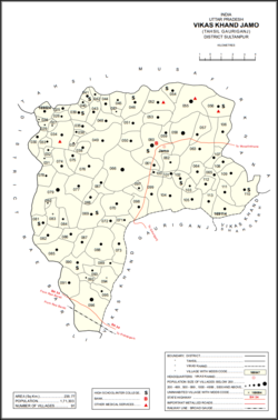
Shahgarh is a village and community development block headquarters in Gauriganj tehsil of Amethi district, Uttar Pradesh, India. As of 2011, it has a population of 3,201 people, in 525 households. It historically was the seat of a taluqdari estate held by a branch of the Bandhalgoti Rajputs. Today it serves as the seat of a nyaya panchayat which also includes 13 other villages.

<span class="mw-page-title-main">Jamo, Uttar Pradesh</span> Village in Uttar Pradesh, India

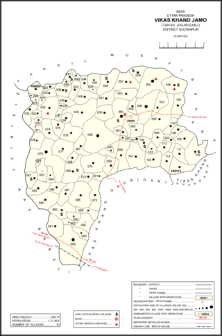
Jamo, also spelled Jamun or Jamon, is a village and community development block headquarters in Gauriganj tehsil of Amethi district, Uttar Pradesh, India. As of 2011, it has a population of 6,734 people, in 1,182 households. It was historically the capital of the pargana of Gaura Jamun. It is located at the intersection of four minor district roads, some of which are prone to flooding during the rainy season.

<span class="mw-page-title-main">Dakhinwara, Amethi</span> Village in Uttar Pradesh, India

Dakhinwara is a village in Jamo block of Amethi district, Uttar Pradesh, India. As of 2011, it has a population of 3,840 people, in 613 households. It has two primary schools and one maternity and child welfare centre and it hosts a weekly haat but not a periodic market. It belongs to the nyaya panchayat of Jamo.

<span class="mw-page-title-main">Katari, Amethi</span> Village in Uttar Pradesh, India

Katari is a village in Jamo block of Amethi district, Uttar Pradesh, India. It is located by a stream called the Naiya or Kandu nala, which flows east toward the Gomti river. The main highway from Lucknow to Jaunpur passes further north. Katari was historically the seat of a taluqdari estate held by a leading branch of the Kanhpuria Rajputs.

<span class="mw-page-title-main">Baraulia</span> Village in Uttar Pradesh, India

Baraulia is a village in Jamo block of Amethi district, Uttar Pradesh, India. As of 2011, it has a population of 3,878 people, in 691 households. It has one primary school and no healthcare facilities and it hosts both a regular market and a weekly haat. It belongs to the nyaya panchayat of Hardo.

<span class="mw-page-title-main">Bakhshgarh</span> Village in Uttar Pradesh, India

Bakhshgarh is a village in Jamo block of Amethi district, Uttar Pradesh, India. As of 2011, it has a population of 1,628 people, in 275 households. It has one primary school and no healthcare facilities and it does not host a weekly haat or a permanent market. It belongs to the nyaya panchayat of Mawai.

<span class="mw-page-title-main">Piparpur, Bhadar</span> Village in Uttar Pradesh, India

Piparpur is a village in Bhadar block of Amethi district, Uttar Pradesh, India. The historical capital of the pargana of Asal, Piparpur is located on the road from Amethi to Chanda, just west of the intersection with the main Allahabad-Faizabad road. Running through the village is a stream that originates in the Bhujwa jhil and flows into neighbouring Prataphgarh district where it joins with the Chamraura. The banks of this stream are well-wooded; they used to be more so, but a lot of it was cut down around the turn of the 20th century to provide materials for the railway. There is also some significant usar land, especially in the north of the village.

<span class="mw-page-title-main">Piparpur, Bhetua</span> Village in Uttar Pradesh, India

Piparpur is a village in Bhetua block of Amethi district, Uttar Pradesh, India. As of 2011, it has a population of 1,025 people, in 186 households. It has one primary school and no healthcare facilities and hosts a weekly haat but not a permanent market. It belongs to the nyaya panchayat of Amey Maphi.

<span class="mw-page-title-main">Naugirwa</span> Village in Uttar Pradesh, India

Naugirwa is a village in Bhetua block of Amethi district, Uttar Pradesh, India. As of 2011, it has a population of 1,168 people, in 220 households. It has one primary school and a veterinary hospital and hosts a weekly haat but not a permanent market. It belongs to the nyaya panchayat of Darai Mafi.

References

  1. "Geonames Search". Do a radial search using these coordinates here.
  2. 1 2 3 4 5 "Census of India 2011: Uttar Pradesh District Census Handbook - Sultanpur, Part A (Village and Town Directory)" (PDF). Census 2011 India. pp. 147–63. Retrieved 17 December 2021.
  3. 1 2 3 4 5 6 7 Nevill, H.R. (1903). Sultanpur: A Gazetteer, Being Volume XLVI Of The District Gazetteers Of The United Provinces Of Agra And Oudh. Allahabad: Government Press. pp. 176–7. Retrieved 17 December 2021.
  4. 1 2 3 4 5 6 7 8 Census 1991 Series-25 Uttar Pradesh Part-XII B Village & Townwise Primary Census Abstract District Census Handbook District Raebareli (PDF). 1992. pp. xxiv–xxviii, 84–5. Retrieved 17 December 2021.
  5. 1 2 3 4 5 Census of India, 1951: District Census Handbook Uttar Pradesh (49 - Rae Bareli District) (PDF). Allahabad. 1955. pp. 128–9, 199. Retrieved 17 December 2021.
  6. 1 2 Census 1961: District Census Handbook, Uttar Pradesh (44 - Sultanpur District) (PDF). Lucknow. 1965. pp. xvi–xvii. Retrieved 17 December 2021.
  7. 1 2 Census 1981 Uttar Pradesh: District Census Handbook Part XIII-A: Village & Town Directory, District Rae Bareli (PDF). 1982. pp. 42–3. Retrieved 17 December 2021.