
The Weissenstein is a mountain of the Jura, located north of Solothurn in the Swiss canton of Solothurn. The culminating point of the chain is distinguished by the name Röti. It is the easternmost summit above 1,300 metres in the Jura Mountains.
The Lägern is a wooded mountain of the Jura Mountains, stretching from Baden to Dielsdorf, about 15 km north-west of Zurich. The culminating point is located 1 km west of Hochwacht within the canton of Zurich, the border with the canton of Aargau running on a slightly lower summit named Burghorn.

The Chasseral is a mountain of the Jura Mountains, overlooking Lake Biel in the Swiss canton of Bern. With an elevation of 1,606 metres above sea level, the Chasseral is the highest summit in the canton of Bern outside the Alps. It is also both the northernmost and easternmost mountain reaching over 1,500 metres in the Jura Mountains. West of the summit is located the Chasseral Ouest, where runs the border with the canton of Neuchâtel. The Chasseral Pass is located further on the west.

Mont Tendre is a mountain of the Jura, located between the valley of Joux and the basin of Lake Geneva in the canton of Vaud. With an elevation of 1,679 metres above sea level, it is the highest summit of the Swiss portion of the Jura Mountains and, therefore, the highest summit of Switzerland outside the Alps. It is also the most isolated mountain of the canton. It is found in the community of Montricher.

The Hasenmatt is a mountain of the Jura range, located north of Grenchen and Solothurn in the Swiss canton of Solothurn. Reaching a height of 1,445 metres above sea level, it is the highest summit in the canton of Solothurn. The Hasenmatt is also the easternmost summit above 1,400 metres of the Jura Mountains.

Mont Raimeux is a mountain of the Jura range, located on the border between the Swiss cantons of Jura and Berne. Reaching a height of 1,302 metres above sea level, it is the highest summit in the canton of Jura.

A Mittelgebirge is a type of relatively low mountain range or highland area typical of the geography of central Europe, especially central and southern Germany; it refers to something between rolling low hill country or Hügelland and a proper mountain range like the High Alps.
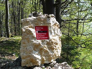
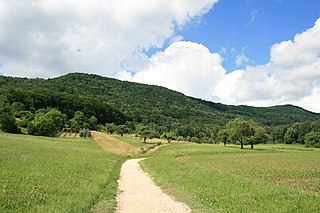
The Hinteri Egg is a mountain of the Jura, located south of Reigoldswil in the Swiss canton of Basel-Landschaft, close to the border with the canton of Solothurn.

The Hage is a mountain in the Randen range between the Jura and the Swabian Jura, located between Beggingen and Merishausen in the Swiss canton of Schaffhausen. Reaching a height of 912 metres above sea level, it is the highest point of the canton.
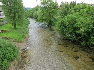
The Sissle is a 16-kilometre (10 mi) long river in the Swiss canton of Aargau in Switzerland. It is a tributary of the Rhine and drains the eastern part of the Fricktal. The largest town on the river is Frick.
The Geissflue is a hill of the eastern Jura Mountains, located between the Swiss cantons of Basel-Landschaft and Solothurn. The border with the canton of Aargau runs east of the summit on the Geissfluegrat.
The Wasserflue is a mountain of the Jura, located north of Erlinsbach in the canton of Aargau. It lies on the range east of the Salhöhe Pass.

The Chasseral Ouest is a prominence west of the Chasseral, in the Jura Mountains. It is located on the border between the Swiss cantons of Neuchâtel and Bern. The Chasseral Ouest reaches an elevation of 1,552 metres above sea level and is the highest point of the canton of Neuchâtel.

Mont Soleil is a mountain of the Jura Mountains, located north of Saint-Imier in the canton of Bern, Switzerland. The summit reaches to 1,291 metres (4,236 ft) and the area can be easily accessed by a funicular from Saint-Imier, reaching a height of 1,180 m (3,870 ft).
The Vogelberg is a mountain of the Jura, located north of Mümliswil in the Swiss canton of Solothurn. It lies east of the Passwang Pass. The border with the canton of Basel-Landschaft runs north of the mountain. The Vogelberg is the easternmost summit above 1,200 metres in the Jura Mountains.

The Stierenberg is a wooded mountain north of the Alps, located between the cantons of Aargau and Lucerne, with the summit being within the canton of Aargau. The Stierenberg is the highest summit between the valleys of the Suhre and Aabach.

The Wisenberg is a wooded mountain of the Jura Mountains, located between Häfelfingen and Wisen in northern Switzerland. The summit lies within the canton of Basel-Landschaft, near the border with the canton of Solothurn. The Wisenberg is both the northernmost and easternmost summit above 1,000 metres in the Jura Mountains.

Aargau Jura Park is located north of Aarau, between the rivers Aare and Rhine, in the Swiss canton of Aargau. It straddles the border between Jura and Basel. It spans 241 square kilometres (93 sq mi) and reaches up to 350 metres (1,150 ft) above the valley floor. The park is mainly located on the Jurassic Plateau, between Frick and Villigen, and also encompasses the Aargau Jura mountains and valleys. The northern area includes sparse pine forests, fruit orchards, rocky steppes, dry meadows and terraced vineyards, while the southern region fosters forests and wildlife. It was declared a regional nature park of national importance in 2012 by the Federal Office for the Environment.
The Ruchen is a mountain of the Jura, located on the border between the Swiss cantons of Basel-Landschaft and Solothurn. It lies between Langenbruck and Eptingen. The Ruchen is the easternmost summit above 1,100 metres in the Jura Mountains. East of the Ruchen is the Belchenflue.

