East Lansing is a city in the U.S. state of Michigan directly east of Lansing, the state capital. Most of the city is within Ingham County, with the rest in Clinton County. The population was 48,579 at the 2010 census, an increase from 46,420 in 2000. It is best known as the home of Michigan State University. It is part of the Lansing–East Lansing metropolitan area.

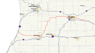
M-99 is a north–south state trunkline highway in the Lower Peninsula of the US state of Michigan. It runs from the Ohio state border, where it connects to State Route 15 (SR 15), north to Lansing, where it terminates at a junction with Interstate 496 (I-496) and the Capitol Loop. The highway mainly serves local communities along the route as it passes through farm lands in the southern part of the state. One segment is routed concurrently with US Highway 12 (US 12) in Jonesville while the northern end runs through urban areas on a street named for Martin Luther King, Jr. in Lansing.
Interstate 496 (I-496) is an auxiliary Interstate Highway that passes through downtown Lansing in the US state of Michigan. Also a component of the State Trunkline Highway System, the freeway connects I-96 to the downtown area. It has been named the R.E. Olds Freeway for Ransom E. Olds, the founder of Oldsmobile and the REO Motor Car Company. I-496 runs east–west from I-96/I-69 near the downtown area and north–south along a section that runs concurrently with US Highway 127 (US 127). The trunkline also passes a former assembly plant used by Oldsmobile and runs along or crosses parts of the Grand and Red Cedar rivers.

M-3 is a north–south state trunkline highway in the Detroit metropolitan area of the US state of Michigan. For most of its length, the trunkline is known as Gratiot Avenue. The trunkline starts in Downtown Detroit and runs through the city in a northeasterly direction along one of Detroit's five major avenues. The highway passes several historic landmarks and through a historic district. It also connects residential neighborhoods on the city's east side with suburbs in Macomb County and downtown.
M-85, also known as Fort Street or Fort Road for its entire length, is a state trunkline highway in the U.S. state of Michigan. The highway serves several Downriver suburbs of Detroit, as well as neighborhoods in the city itself. From its southern terminus at exit 28 on Interstate 75 (I-75) to its second interchange with exit 43 on I-75 in southwest Detroit, M-85 is part of the Lake Erie Circle Tour. In between, it serves mostly residential areas running parallel to a pair of rail lines; the highway carries between 5,000 and 43,000 vehicles per day on average. Once in the city of Detroit, Fort Street runs parallel to I-75 for several miles before they separate near the Ambassador Bridge. The northern end of M-85 is at the intersection with Griswold Street in downtown Detroit, one block away from Campus Martius Park.
Business M-28 is a state trunkline highway serving as a business route that runs for 4.841 miles (7.791 km) through the downtown districts of Ishpeming and Negaunee in the US state of Michigan. The trunkline provides a marked route for traffic diverting from U.S. Highway 41 (US 41) and M-28 through the two historic iron-mining communities. It is one of three business loops for M-numbered highways in the state of Michigan. There have previously been two other Bus. M-28 designations for highways in Newberry and Marquette.

M-156 is a state trunkline highway in the US state of Michigan. The highway is entirely within Lenawee County and begins in Morenci at the Ohio state line with State Route 108 (SR 108) and runs north to M-34 at Clayton. The highway runs through farm land along Lime Creek outside of the two communities, providing access to the Lake Hudson State Recreation Area. The trunkline dates back to the early 1930s, and has been unchanged since a realignment in 1980.
US Highway 12 (US 12) is an east–west US Highway that runs from Aberdeen, Washington, to Detroit, Michigan. In Michigan it runs for 210 miles (338 km) between New Buffalo and Detroit as a state trunkline highway and Pure Michigan Byway. On its western end, the highway is mostly a two-lane road that runs through the southern tier of counties roughly parallel to the Indiana state line. It forms part of the Niles Bypass, a four-lane expressway south of Niles in the southwestern part of the state, and it runs concurrently with the Interstate 94 (I-94) freeway around the south side of Ypsilanti in the southeastern. In between Coldwater and the Ann Arbor area, the highway angles northeasterly and passes the Michigan International Speedway. East of Ypsilanti, US 12 follows a divided highway routing on Michigan Avenue into Detroit, where it terminates at an intersection with Cass Avenue.
There are three business routes of US Highway 10 in the state of Michigan. They serve as connections from the main highway into Reed City, Clare and Midland. Additionally, there were another two business routes that connected US Highway 10 (US 10) to the downtowns of Flint and Pontiac. All of these business routes are, or were, former sections of US 10 that were marked Business US Highway 10 after the main highway was realigned to bypass the downtowns of the cities.
There are currently eight business routes of Interstate 94 (I-94) in the US state of Michigan. These business routes connect I-94 to the downtown business districts of neighboring cities. These eight routes are all business loops which bear the Business Loop I-94 designation. These loops are former routings of I-94's two predecessors in Michigan: US Highway 12 (US 12) or US 25. The westernmost BL I-94 runs through the twin cities of Benton Harbor and St. Joseph along the former routing of US 12 and US 31/US 33 that now includes a section of the Lake Michigan Circle Tour in the state. The loops in Kalamazoo, Battle Creek, Marshall, Albion, and Jackson were also formerly segments of US 12 which were later designated as separate version of Business US Highway 12 through their respective cities before becoming BL I-94s in 1960. The route of the business loop through Ann Arbor was previously US 12 and then later M-14 before receiving its current moniker. The BL I-94 through Port Huron was previously US 25 and then Business US Highway 25.
There are five business routes of US Highway 131 in the state of Michigan, and previously there was one bypass route and an additional business route. All of the business routes are former sections of US Highway 131 (US 131). These former sections of the mainline highway, along with the necessary connecting roads, allow traffic to access the downtowns business districts of cities bypassed by sections of US 131 built since the 1950s. The extant business loops connect to Constantine, Three Rivers, Kalamazoo, Big Rapids, Cadillac, and Manton. The former bypass route in Grand Rapids allowed traffic to bypass that city's downtown at a time when US 131 still ran through the heart of the city, and the later business route connected through downtown while US 131 ran on a freeway bypassing the central business district.
There are currently four business routes of Interstate 69 (I-69) in the US state of Michigan. Designated Business Loop Interstate 69, they are all former routings of I-69's predecessor highways, US Highway 27 (US 27), M-78 or M-21, in whole or in part. The BL I-69 in Coldwater and the one in Charlotte were both parts of US 27 before the freeway bypassed those two cities in 1967 and the early 1970s, respectively. The BL I-69 through Lansing and East Lansing was previously part of M-78 and Temporary I-69 until it was redesignated in 1987. Before 1984, the loop in Port Huron was originally part of M-21 and was initially a business spur numbered Business Spur Interstate 69. It was later redesignated when it was extended to run concurrently with that city's BL I-94 which was originally part of I-94's predecessor, US 25. Each business loop follows streets through each city's downtown areas and connects to I-69 on both ends, giving traffic a route through the downtown and back to the freeway.
There have been six business routes of Interstate 96 (I-96) in the US state of Michigan. There are two business loops designated Business Loop Interstate 96 : one through Lansing and one through Howell. Both follow the old route of US Highway 16 (US 16), with appropriate connections to I-96. There are three former business spurs that were designated Business Spur Interstate 96. One connected to the carferry docks in Muskegon, running concurrently with part of Business US 31 along former US 16, but it has been eliminated. The second spur ran into downtown Portland until it was decommissioned in 2007. Two routes in the Detroit area—a loop through Farmington and a spur into Detroit—both using Grand River Avenue, and meeting at the temporary end of I-96 near Purdue Avenue, were eliminated when I-96 was moved to the completed Jeffries Freeway in 1977. These Detroit-area business routes are still state-maintained as unsigned highways.
There have been nine business routes for Interstate 75 in the US state of Michigan. Numbered either Business Loop Interstate 75 or Business Spur Interstate 75 depending if they are a full business loop or a business spur, these highways are former routings of I-75's predecessor highways in the state. They were designated as I-75 was completed through the various areas of Michigan. The business loop in Pontiac runs through that city's downtown along a section of Woodward Avenue and a segment of roadway formerly used by M-24. The former Saginaw business loop was once a part of US Highway 23 (US 23), as was most of the original Bay City business loop. The roadways that make up the business loops in West Branch and Roscommon were previously part of M-76, I-75's predecessor through that part of the state. In Northern Michigan, the Grayling and Gaylord BL I-75s were part of US 27, and the two business routes in St. Ignace and Sault Ste. Marie in the Upper Peninsula of Michigan were part of US 2. A tenth business route, a loop through Indian River has been proposed. Each of the business loops connects to I-75 on both ends and runs through their respective cities' downtown areas. The two business spurs only connect to I-75 on one end and run into the appropriate downtown.

REO Town is a district in Lansing, Michigan, located south of downtown. The neighborhood is bordered by West Malcolm X Street to the north; South Cedar Street BL I-96 to the east; West Mount Hope Ave to the south; and Townsend Street, the Grand River, and S Martin Luther King JR Blvd to the west. Considered the birthplace of the commercial automobile in the United States, REO Town is named after Ransom Eli Olds, an automobile pioneer, for whom both the Oldsmobile and REO brands were named. In addition to a commercial corridor along South Washington Avenue, REO Town includes three neighborhoods: Fabulous Acres, Moores Park, and River Point.

Colonial Village is a neighborhood in Lansing, Michigan. It is located southwest of REO Town in the southside of the city.
There have been 10 business routes of US Highway 127 in the state of Michigan. The business routes are all sections of state trunkline highway that run through the central business districts of their respective towns connecting them to the mainline highway outside of those downtown areas. These various business routes were formerly part of the routing of US Highway 127 (US 127) or its predecessor in Central Michigan, US 27, before the construction of highway bypasses. The southern two, in Jackson and Mason were previously parts of US 127, while seven of the northern eight were originally part of US 27, a highway which was replaced on its northern end by US 127 in 2002. The business loop through Alma was once numbered US 27A.
There have been seven business routes of US Highway 31 in the state of Michigan. All of the business routes are former sections of US Highway 31 (US 31). They connect the freeway mainline of US 31 to the various downtowns of cities bypassed by US 31. Two of the current business routes, for Hart and Ludington, are business spurs, connecting to US 31 on only one end, while the remainder for Muskegon, Whitehall–Montague and Pentwater, are business loops. The two former routes, for Niles and Holland were a business spur and loop, respectively.

Downtown Lansing is the central business district of Lansing, Michigan, United States. Located in the west-central part of the city along the banks of the Grand River, downtown Lansing is primarily home to Michigan's state government and three colleges, and also contains sports facilities, museums, entertainment and retail, and a growing residential population.