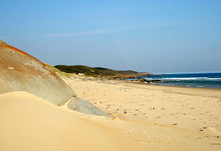
The Croajingolong National Park is a coastal national park located in the East Gippsland region of the Australian state of Victoria. The 88,355-hectare (218,330-acre) national park is situated approximately 450 kilometres (280 mi) east of Melbourne and 500 kilometres (310 mi) south of Sydney.

Gippsland is a rural region that makes up the southeastern part of Victoria, Australia, mostly comprising the coastal plains to the rainward (southern) side of the Victorian Alps. It covers an elongated area of 41,556 km2 (16,045 sq mi) located further east of the Shire of Cardinia between Dandenong Ranges and Mornington Peninsula, and is bounded to the north by the mountain ranges and plateaus/highlands of the High Country, to the southwest by the Western Port Bay, to the south and east by the Bass Strait and the Tasman Sea, and to the east and northeast by the Black–Allan Line.

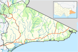
The Shire of East Gippsland is a local government area in Gippsland, Victoria, Australia, located in the eastern part of the state. It covers an area of 20,940 square kilometres (8,080 sq mi) and as of the 2021 census had a population of 48,715.

Mallacoota is a small town in the East Gippsland region in the state of Victoria, Australia. At the 2021 census, Mallacoota had a population of 1,183. At holiday times, particularly Easter and Christmas, the population increases by about 8,000. It is the last official township on Victoria's east coast before the border with New South Wales. Mallacoota has a regional airport YMCO (XMC) consisting of a gravel runway for light planes and an asphalt runway for commercial planes flying from Melbourne.

Orbost is a historic early settlers town in the Shire of East Gippsland, Victoria, 375 kilometres (233 mi) east of Melbourne and 235 kilometres (146 mi) south of Canberra where the Princes Highway crosses the Snowy River. It is about 16 kilometres (10 mi) from the surf and fishing seaside town of Marlo on the coast of Bass Strait and 217 km (135 mi) drive to Hotham Alpine Resort. Orbost is the service centre for the primary industries of beef, dairy cattle and sawmilling. More recently, tourism has become an important and thriving industry, being the major town close to several national parks that are between the east access to either the surf or the snow, including the famous Snowy River National Park, Alpine National Park, Errinundra National Park, Croajingolong National Park and Cape Conran Coastal Park.
East Gippsland is the eastern region of Gippsland, Victoria, Australia covering 31,740 km2 (12,250 sq mi) (14%) of Victoria. It has a population of 80,114.

Cann River is a town in the East Gippsland region of Victoria, Australia. The town is located on the Cann River at the junction of the Princes Highway and the Monaro Highway, in the Shire of East Gippsland. At the 2016 census, Cann River had a population of 194 people.

Bemm River is a township and locality in the East Gippsland region of Victoria, Australia. At the 2016 census, Bemm River and the surrounding area had a population of 60.
The Cann River is a perennial river located in the East Gippsland region of the Australian state of Victoria.

The Shire of Orbost was a local government area about 380 kilometres (236 mi) east of Melbourne, the state capital of Victoria, Australia. The shire covered an area of 9,347 square kilometres (3,608.9 sq mi), and existed from 1892 until 1994.
Genoa River is a perennial river located in the Monaro region of New South Wales and flows into the East Gippsland region of Victoria in Australia. It used to be known as Bondi Creek or Yard Creek. The river's name derives from the First People "jinoor" ("footpath").

The Wallagaraugh River is a perennial river of the Genoa River catchment, with its headwaters located in the South Coast region of New South Wales and its lower reaches located in the East Gippsland region of Victoria, Australia. In earlier times, an alternative name for the river was Timbillica River.
The Mueller River is a perennial river with no defined major catchment, located in the East Gippsland region of the Australian state of Victoria.

The Benedore River is a perennial river with no defined major catchment, located in the East Gippsland region of the Australian state of Victoria.

The Betka River is a perennial river with no defined major catchment, located in the East Gippsland region of the Australian state of Victoria.

The Thurra River is a perennial river with no defined major catchment, located in the East Gippsland region of the Australian state of Victoria.

The Wingan River is a perennial river with no defined major catchment, located in the East Gippsland region of the Australian state of Victoria.
The Teal Creek, formerly known as Little River, is a perennial stream of the Genoa River catchment, located in the East Gippsland region of the Australian state of Victoria.
Lake Barracoota is a naturally forming permanent freshwater lake located in the East Gippsland region in the Australian state of Victoria. The lake is located entirely within the Croajingolong National Park and when full, the surface area of the lake is 240 hectares.
Wingan River is a locality in the Shire of East Gippsland, Victoria, Australia. It is situated on the river of the same name. In the 2016 census, Wingan River had a population of zero.