Geography of Bratislava

Last updated
Location of Bratislava within the Bratislava Region and within Slovakia Map slovakia bratislava.png
Location of Bratislava within the Bratislava Region and within Slovakia
Bratislava's highest point, Devinska Kobyla, part of the Little Carpathians mountain range Devinska Kobyla 02.jpg
Bratislava's highest point, Devínska Kobyla, part of the Little Carpathians mountain range

Bratislava , the capital city of Slovakia, is situated in Central Europe and it is located in the extreme south-west within Slovakia. The city borders Austria in the west and Hungary in the south making it the only national capital in the world to border two foreign countries. The state border with the Czech Republic is only 62 km (39 mi) distant. [1] Bratislava lies on the foothills of the Little Carpathians mountains and the city straddles both banks of the Danube River. The city has a total area of 367.58 km2 (141.92 sq mi), making it the second largest city in Slovakia by area (after the township of Vysoké Tatry). Geomorphologically the city covers the southern tip of the Záhorie Lowland, the entire range of the Devín Carpathians, small westernmost part of the Pezinok Carpahians and the northern tip of the Danubian Lowland.

Contents

The Danube crosses the city from the west to the south-east. The Middle Danube basin begins at Devín Gate in western Bratislava. Other rivers nearby are the Morava River, which forms the north-western border of the city and flows into the Danube at Devín, the Little Danube, and the Vydrica, which flows into the Danube at the borough of Karlova Ves. Some parts of Bratislava, particularly Devín and Devínska Nová Ves, are vulnerable to floods. [2] New flood protection is being built on both banks. [3]

The Carpathian mountain range begins in city territory with the Little Carpathians (Malé Karpaty). The area includes Bratislava Forest Park, which is popular with many Bratislavans and is part of the Little Carpathians Protected Landscape Area. The city's lowest point is at the Danube's surface, at 126 m (413 ft) above mean sea level, and the highest point is Devínska Kobyla at 514 m (1,686 ft). The average altitude is 140 m (460 ft). [4] The Záhorie and Danubian Lowlands are partly situated in the city.

The nearest towns and villages are: to the north Stupava, Borinka and Svätý Jur; to the east Ivanka pri Dunaji and Most pri Bratislave; to the south-east Rovinka, Dunajská Lužná and Šamorín; to the south Rajka (HU); and to the west Kittsee (AT), Hainburg an der Donau (AT) and Marchegg (AT).

Distances from selected European cities

Bratislava is situated: 62 km from Vienna; 196 km from Budapest; 324 km from Prague; 532 km from Warsaw; 569 km from Belgrade; 769 km from Zürich; 1005 km from Kyiv; 1266 km from Paris; 1273 km from Amsterdam; 1314 km from Rome; 1473 km from Istanbul; 1602 km from London; 1735 km from Stockholm; 1886 km from Athens; 2104 km from Moscow and 2261 km from Madrid.

Climate

Bratislava lies in the north temperate zone and has a temperate climate, transitioning to humid continental climate with four distinct seasons. It is often windy with a marked variation between hot summers and cold, humid winters. Recently, the transitions from winter to summer and summer to winter have been rapid, with short autumn and spring periods and the weather is occasionally extreme, quickly changing its state. [5] Snow occurs less frequently now than previously. [5]

Climate data for Bratislava airport (normals and extremes 1991-2020)
MonthJanFebMarAprMayJunJulAugSepOctNovDecYear
Record high °C (°F)19.7
(67.5)
20.3
(68.5)
23.5
(74.3)
30.5
(86.9)
33.4
(92.1)
36.3
(97.3)
38.2
(100.8)
39.4
(102.9)
33.0
(91.4)
27.6
(81.7)
21.5
(70.7)
16.7
(62.1)
39.4
(102.9)
Mean daily maximum °C (°F)3.1
(37.6)
5.8
(42.4)
11.1
(52.0)
17.5
(63.5)
21.7
(71.1)
25.6
(78.1)
28.0
(82.4)
27.9
(82.2)
21.9
(71.4)
15.6
(60.1)
9.3
(48.7)
3.7
(38.7)
15.9
(60.7)
Daily mean °C (°F)0.3
(32.5)
1.9
(35.4)
6.1
(43.0)
11.7
(53.1)
16.2
(61.2)
20.2
(68.4)
22.0
(71.6)
21.5
(70.7)
16.2
(61.2)
10.7
(51.3)
5.7
(42.3)
1.1
(34.0)
11.1
(52.1)
Mean daily minimum °C (°F)−2.8
(27.0)
−1.7
(28.9)
1.7
(35.1)
5.7
(42.3)
10.6
(51.1)
14.2
(57.6)
16.2
(61.2)
15.9
(60.6)
11.2
(52.2)
6.3
(43.3)
2.6
(36.7)
−1.5
(29.3)
6.5
(43.8)
Record low °C (°F)−18.2
(−0.8)
−19.8
(−3.6)
−13.9
(7.0)
−4.5
(23.9)
0.2
(32.4)
4.8
(40.6)
8.4
(47.1)
7.3
(45.1)
0.8
(33.4)
−7.4
(18.7)
−12.5
(9.5)
−20.3
(−4.5)
−20.3
(−4.5)
Average precipitation mm (inches)37.4
(1.47)
32.9
(1.30)
36.8
(1.45)
35.9
(1.41)
58.6
(2.31)
59.2
(2.33)
61.8
(2.43)
60.5
(2.38)
58.6
(2.31)
43.6
(1.72)
46.2
(1.82)
42.7
(1.68)
574.2
(22.61)
Average precipitation days (≥ 1.0 mm)7.56.575.68.17.77.976.56.47.7885.9
Average snowy days11.28.75.81.3000000.24.18.639.9
Average relative humidity (%)80.974.767.56162.86260.562.369.276.881.983.270.2
Mean monthly sunshine hours 65.599.3153.7218.6258.1269.4286.5273.3194.5134.669.651.92,075
Source: NOAA NCEI [6]


Climate data for Koliba, Bratislava (normals 1991-2020)
MonthJanFebMarAprMayJunJulAugSepOctNovDecYear
Mean daily maximum °C (°F)2.5
(36.5)
5.5
(41.9)
10.6
(51.1)
17.0
(62.6)
21.2
(70.2)
25.0
(77.0)
27.2
(81.0)
27.2
(81.0)
21.2
(70.2)
14.8
(58.6)
8.1
(46.6)
2.9
(37.2)
15.3
(59.5)
Daily mean °C (°F)−0.3
(31.5)
1.5
(34.7)
5.8
(42.4)
11.3
(52.3)
15.6
(60.1)
19.4
(66.9)
21.2
(70.2)
21.1
(70.0)
15.8
(60.4)
10.5
(50.9)
5.1
(41.2)
0.4
(32.7)
10.6
(51.1)
Mean daily minimum °C (°F)−2.7
(27.1)
−1.5
(29.3)
2.0
(35.6)
6.7
(44.1)
10.9
(51.6)
14.4
(57.9)
16.3
(61.3)
16.3
(61.3)
11.9
(53.4)
7.2
(45.0)
2.8
(37.0)
−1.7
(28.9)
6.9
(44.4)
Average precipitation mm (inches)45.7
(1.80)
42.8
(1.69)
48.3
(1.90)
43.4
(1.71)
68.2
(2.69)
72.1
(2.84)
70.8
(2.79)
70.0
(2.76)
74.0
(2.91)
55.4
(2.18)
57.0
(2.24)
53.4
(2.10)
701.1
(27.61)
Average precipitation days (≥ 1.0 mm)8.47.48.16.58.98.18.977.57.78.79.296.4
Average snowy days12.8107.31.7000000.65.410.147.9
Average relative humidity (%)82.576.167.860.864.864.562.763.771.179.184.887.772.1
Mean monthly sunshine hours 64.298156.5220.4264.8272.3292.4278.9195.2136.26648.72,093.6
Source: NOAA NCEI [6]

Rivers and lakes in Bratislava

Twenty water streams originate in the area of Bratislava. Four rivers flow through the area of the city: Danube, Morava river, Little Danube and partially Malina.

In addition, 18 streams (Slovak : potok) and 9 canals (Slovak : kanál) or canalized streams flow through the city. The following is their list in alphabetical order:

Panorama of the city

Bratislava - 52119321317.jpg
Panorama of the Old Town from Bratislava Castle

See also

Related Research Articles

<span class="mw-page-title-main">Morava (river)</span> River in Central Europe

The Morava is a river in Central Europe, a left tributary of the Danube. It is the main river of Moravia, which derives its name from it. The river originates on the Králický Sněžník mountain in the north-eastern corner of Pardubice Region, near the border between the Czech Republic and Poland and has a vaguely southward trajectory. The lower part of the river's course forms the border between the Czech Republic and Slovakia and then between Austria and Slovakia.

<span class="mw-page-title-main">Trenčín Region</span> Region of Slovakia

The Trenčín Region is one of the eight Slovak administrative regions. It consists of nine districts (okresy). The region was established in 1996: previously it had been a part of the West Slovak Region and partly the Central Slovak Region. Industry is a major sector of the region's economy.

<span class="mw-page-title-main">Trnava Region</span> Region of Slovakia

The Trnava Region is one of the eight Slovak administrative regions. It was established in 1996, before which date, most of its districts were parts of Bratislava Region which was established on the founding of Czechoslovakia in 1923. It consists of 251 municipalities, from which 16 have a town status. It is the second most densely populated region in Slovakia.

<span class="mw-page-title-main">Bratislava Region</span> Region of Slovakia

The Bratislava Region is one of the administrative regions of Slovakia. Its capital is Bratislava. The region was first established in 1923 and its present borders exist from 1996. It is the smallest of the eight regions of Slovakia as well as the most urbanized, most developed and most productive by GDP per capita.

<span class="mw-page-title-main">Devín</span> Borough in Slovakia

Devín is a borough of Bratislava, the capital of Slovakia, located in the Bratislava IV district. Originally a separate village at the confluence of the Danube and Morava rivers, Devín maintained its rural character and today, it is one of the smallest boroughs of Bratislava by population. It is an important archaeological site, featuring the ruins of Devín Castle.

<span class="mw-page-title-main">Danubian Flat</span>

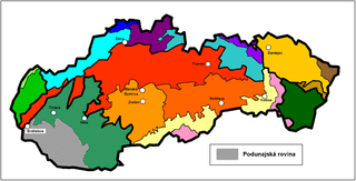
The Danubian Flat, also translated as Danubian Plain, is the south-western, flatter, part of the Danubian Lowland in Slovakia.

<span class="mw-page-title-main">Devínska Nová Ves</span> Borough of Bratislava, Slovakia

Devínska Nová Ves is a borough of Bratislava, the capital of Slovakia. Its western borders are formed by the Morava River, which also forms the national border between Slovakia and Austria.

<span class="mw-page-title-main">Záhorie</span> A region located in western Slovakia

Záhorie is a region in western Slovakia between the Little Carpathians to the east and the Morava River to the west. Although not an administrative region, it is one of the 21 official tourism regions in Slovakia. Záhorie lies in the area of three administrative regions: Bratislava Region, Trnava Region and Trenčín Region. The region also creates the borders between Slovakia, the Czech Republic and Austria.

<span class="mw-page-title-main">Devín Gate</span>

Devín Gate, Hainburger Gate or Hungarian Gates is a natural gate in the Danube valley at the border of Slovakia and Austria. It is one out of four geomorphological areas of the Devín Carpathians, part of the Little Carpathians mountain range. Passau, Devín Gate, and the Iron Gates divide the Danube river into four distinct sections.

<span class="mw-page-title-main">Little Carpathians</span> Mountain range in Slovakia and Austria

The Little Carpathians are a low mountain range, about 100 km long, and part of the Carpathian Mountains. The mountains are situated in Western Slovakia, covering the area from Bratislava to Nové Mesto nad Váhom, and northeastern Austria, where a very small part called Hundsheimer Berge is located south of the Devín Gate. The Little Carpathians are bordered by the Záhorie Lowland in the west and the Danubian Lowland in the east.

<span class="mw-page-title-main">Devínska Kobyla</span>

Devínska Kobyla is the highest peak in the Devín Carpathians, part of the Little Carpathians mountain range, and the highest point of Bratislava, the capital of Slovakia. It is located between the boroughs of Devínska Nová Ves, Devín and Dúbravka, close to the border with Austria. Its peak elevation is 514 m (1686.3 ft) AMSL and its treeless summit contains an abandoned military missile base that is officially inaccessible to the public.

<span class="mw-page-title-main">Bratislava fortifications</span> Medieval fortifications of Bratislava, Slovakia

Bratislava fortifications usually refers to the medieval city fortifications of Bratislava, the capital of Slovakia, of which one gate and two sections of walls remain today. The Bratislava Castle was also heavily fortified. Other fortification systems were built in the following centuries, including a World War I artillery fortification system and World War I shelters, system of bunkers and fortifications built by the First Czechoslovak Republic between the World Wars, World War II aircraft raid shelters, fortifications built by the Nazi Germany in the city during World War II and finally Cold War-era city defenses including a system of 8,602 air raid and nuclear shelters capable of holding over 760,000 citizens, far more than the number of inhabitants. The pinnacle of the communist era city defense was a military rocket base located on the Devínska Kobyla hill, the highest point in the city.

<span class="mw-page-title-main">Myjava (river)</span> River in Czech Republic, Slovakia

The Myjava River is a river in western Slovakia and for a small part in the Czech Republic and left tributary of the Morava. It is 80 km (50 mi) long.

<span class="mw-page-title-main">Bratislava</span> Capital of Slovakia

Bratislava, historically known as Preßburg (Pressburg), is the capital and largest city of Slovakia. Officially, the population of the city is about 475,000; however, it is estimated to be more than 660,000—approximately 140% of the official figures. Bratislava is in southwestern Slovakia at the foot of the Little Carpathians, occupying both banks of the River Danube and the left bank of the River Morava. Bordering Austria and Hungary, it is the only national capital to border two sovereign states.

<span class="mw-page-title-main">Hydrology of Hungary</span>

The hydrology of Hungary, is mostly determined by Hungary's lying in the middle of the Carpathian Basin, half surrounded by the Carpathian Mountains. All parts of the country have some outflow. All surface water gravitates towards its southern center, and from there, is united in the Danube, which flows into the Black Sea. The whole of Hungary lies within the Danube drainage basin.

<span class="mw-page-title-main">Vienna Basin</span> Sedimentary basin in Central Europe

The Vienna Basin is a geologically young tectonic burial basin and sedimentary basin in the seam area between the Alps, the Carpathians and the Pannonian Plain. Although it topographically separates the Alps from the Western Carpathians, it connects them geologically via corresponding rocks underground.

<span class="mw-page-title-main">Devín Carpathians</span>

Devín Carpathians is a subdivision of the Little Carpathians mountain range, located entirely within Bratislava, the capital of Slovakia. It is bordered by the city boroughs of Devín from the west, Devínska Nová Ves from the north, Dúbravka from the east and Karlova Ves from the south. Its highest mountain is Devínska Kobyla at 514 m AMSL, it is also the highest point in Bratislava. The hills are mostly forested with deciduous trees and most of the area is protected by numerous nature reserves, including two geologically important areas: Sandberg containing sands and sandstones from the Cenozoic Paratethys ocean and Jezuitské Lesy containing rare granitic pegmatite bearing niobium-tantalum oxide minerals.

<span class="mw-page-title-main">Sihoť</span>

Sihoť is the largest river island on the Danube in Bratislava, the capital of Slovakia, located in the district of Karlova Ves. The island lies between the main flow of the Danube to the north and the parallel channel Karloveské rameno to the south, between Devínska cesta in Bratislava and the Austrian border. It contains a culturally protected water source supplying tap water to a large portion of Bratislava citizens, as well as numerous nearby villages.

Lamač Gate is a tectonic erosion subsidence in Bratislava, the capital of Slovakia. It is one out of four geomorphological areas of the Devín Carpathians, part of the Little Carpathians mountain range, separating Devín Carpathians from the central massif of Little Carpathians. The city borough of Lamač and parts of Dúbravka lie geographically within the Lamač Gate.

<span class="mw-page-title-main">Stupava, Slovakia</span> Town in Slovakia

Stupava is a town in western Slovakia. It is situated in the Malacky District, Bratislava Region.

References

  1. Autoatlas - Slovenská republika (Map) (6th ed.). Vojenský kartografický ústav a.s. 2006. ISBN   80-8042-378-4. Archived from the original on 2006-01-18. Retrieved 2007-06-10.
  2. "Defences hold fast in Bratislava". Nick Thorpe, BBC. August 16, 2002. Retrieved April 27, 2007.
  3. "Začne sa budovať protipovodňový systém mesta (Construction starts for city's flood protection)" (in Slovak). Juraj Handzo, Bratislavské Noviny. January 24, 2007. Retrieved April 28, 2007.
  4. "Basic Information - Position". City of Bratislava. February 14, 2005. Archived from the original on July 31, 2007. Retrieved May 1, 2007.
  5. 1 2 "Bratislava Weather". City of Bratislava. February 14, 2005. Archived from the original on April 18, 2013. Retrieved April 25, 2007.
  6. 1 2 "Slovakia WMO normals 1991-2020". NOAA . Retrieved 20 January 2024.