Ethnicity
In year 2021 was 3913 people by ethnicity 3446 as Slovak, 318 as Not found out, 91 as Hungarian, 47 as Czech, 33 as Rusyn, 29 as Other, 23 as Ukrainian, 8 as Russian, 6 as German, 5 as Italian, 5 as Romani, 5 as Greek, 4 as Austrian, 4 as French, 3 as Chinese, 3 as Serbian, 3 as Polish, 3 as Moravian, 2 as Croatian, 2 as Bulgarian, 1 as Turkish, 1 as Romanian and 1 as Albanian.
| Note on population |
|---|
The difference between the population numbers above and in the census (here and below) is that the population numbers above are mostly made up of permanent residents, etc.; and the census should indicate the place where people actually mainly live.
For example, a student is a citizen of a village because he has permanent residence there (he lived there as a child and has parents), but most of the time he studies at a university in the city. |
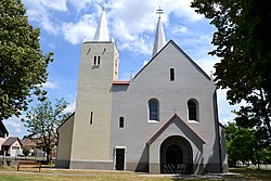
Religion
In year 2021 was 3913 people by religion 1710 from Roman Catholic Church, 1552 from None, 318 from Not found out, 125 from Evangelical Church, 76 from Greek Catholic Church, 32 from Eastern Orthodox Church, 20 from Ad hoc movements, 17 from Other and not ascertained christian church, 14 from Christian Congregations in Slovakia, 9 from Islam, 9 from Other, 5 from Seventh-day Adventist Church, 4 from Church of the Brethren, 4 from Buddhism, 3 from Jewish community, 3 from Jehovah's Witnesses, 3 from United Methodist Church, 2 from Calvinist Church, 2 from Church of Jesus Christ of Latter-day Saints, 2 from Apostolic Church, 1 from Paganism and natural spirituality, 1 from Hinduism and 1 from Czechoslovak Hussite Church.
According to the 2011 census, the municipality had 2,144 inhabitants. 1,883 of inhabitants were Slovaks, 41 Hungarians, 20 Czechs and 200 others and unspecified. [11]
According to the 2021 census, the population has increased to 3,913, 87% of whom were Slovaks and 2% Hungarians. [12]