Mississauga is a city in the Canadian province of Ontario. It is a suburb of Toronto. The city is situated in the Regional Municipality of Peel and covers 288.42 square kilometres (111.36 sq mi) of land, [1] fronting 13 kilometres (8.1 mi) of shoreline on Lake Ontario.
Mississauga is bounded by Oakville and Milton to the west/southwest, Brampton to the north, Toronto to the east, and Lake Ontario to the south/south-east. Halton Hills borders Mississauga's north-west corner. With the exception of the southeast border with Toronto (Etobicoke Creek), Mississauga shares a land border with all of the previous mentioned municipalities.
Two major river valleys feed into the lake. The Credit River is by far the longest with the heaviest flow. It divides the western side of Mississauga from the central/eastern portions and enters the lake at the Port Credit harbour 600 m (0.37 mi) west of Hurontario Street. The indented, mostly forested valley was inhabited by First Nation peoples long before European exploration of the area. The valley is protected and maintained by the Credit Valley Conservation Authority (CVCA).
Etobicoke Creek forms part of the eastern border of Mississauga with the City of Toronto as far north as Eglinton Avenue. North of there it passes through the western infield area of Toronto Pearson International Airport. There have been two aviation accidents, in 1978 and 2005, where aircraft overshot the runway and slid into the Etobicoke creek banks. In 1954, heavy flooding resulted in some homes along the riverbank being swept into the lake after heavy rains from Hurricane Hazel. Since that storm, houses are no longer constructed along this floodplain. This creek and its tributaries are administered by the Toronto and Region Conservation Authority (TRCA).
Most land in Mississauga drains to either of the two main river systems, with the exception of the smaller Mary Fix and Cooksville creeks which run roughly through the centre of Mississauga, entering the lake east of Hurontario St. Some small streams and reservoirs are part of the Sixteen Mile Creek system in the far northwest corner of the city, but these drain toward the lake in neighbouring Milton and Oakville.
The shoreline of former Glacial Lake Iroquois roughly follows the Dundas Street alignment. It is not noticeable in most places but is very prominent in the vicinity of the Dundas Street and Mavis Road intersection, where the ancient shoreline drops below, affording a clear view of downtown Toronto and Lake Ontario on clear days from the ridge. The land in Mississauga in general slopes gradually downward from almost 190 metres (623 ft) above sea level in some northern spots to Lake Ontario (76 m/249 ft ASL), a 110-metre (361 ft) difference over an averaged 15 kilometres (9 mi) distance.
Apart from the Credit River valley and Iroquois shoreline, the only noticeable hills in Mississauga are actually part of the former Britannia Landfill near Britannia Road and Terry Fox Way.
As defined by the Canadian census, the following areas are neighbourhoods in Mississauga. [2]
The climate of Mississauga is officially represented by Pearson International Airport but conditions can differ depending on location: fog tends to be more common along the lakeshore and in the Credit River Valley at certain times of year, particularly during the autumn. The southwestern side of the city (Clarkson) is usually significantly milder in winter and also on summer nights than northern areas which include the airport, while lakeshore areas particularly from Port Credit east through Lakeview are cooler on hot summer days and it can be noticeably cooler on sunny spring days when there is a lake breeze.
During snowfalls when temperatures hover close to freezing, northern parts of the city, such as around Derry Road away from warmer Lake Ontario, tend to get more snow than the southern parts because of colder temperatures. The reverse occurs when a strong storm approaches from the south kicking up lake effect snow, bringing higher snowfall totals to south Mississauga.
Summer thunderstorms are common, most are not severe but can occasionally bring violent winds. The last known tornado to cause significant damage touched down on July 7, 1985, when an F1 rated tornado struck an industrial park in the Meadowvale area, heavily damaging some buildings and some parked tractor trailers. A relatively strong tornado tore a path across Toronto Township (the precursor municipality to Mississauga) on June 24, 1923, cutting a swath from present-day Meadowvale to near Cooksville, killing four people and causing massive property damage in a time when most of the area was still rural farmland dotted with fruit orchards.[ citation needed ]
Climate data for Lester B. Pearson International Airport (Brampton and North Mississauga) WMO ID: 71624; coordinates 43°40′38″N79°37′50″W / 43.67722°N 79.63056°W , elevation: 173.4 m (569 ft), 1981–2010 normals | |||||||||||||
---|---|---|---|---|---|---|---|---|---|---|---|---|---|
Month | Jan | Feb | Mar | Apr | May | Jun | Jul | Aug | Sep | Oct | Nov | Dec | Year |
Record high humidex | 19.0 | 18.3 | 29.6 | 37.9 | 42.6 | 45.6 | 50.3 | 46.6 | 48.0 | 39.1 | 28.6 | 23.9 | 50.3 |
Record high °C (°F) | 17.6 (63.7) | 17.7 (63.9) | 26.0 (78.8) | 31.1 (88.0) | 34.4 (93.9) | 36.7 (98.1) | 37.9 (100.2) | 38.3 (100.9) | 36.7 (98.1) | 31.8 (89.2) | 25.1 (77.2) | 20.0 (68.0) | 38.3 (100.9) |
Average high °C (°F) | −1.5 (29.3) | −0.4 (31.3) | 4.6 (40.3) | 12.2 (54.0) | 18.8 (65.8) | 24.2 (75.6) | 27.1 (80.8) | 26.0 (78.8) | 21.6 (70.9) | 14.3 (57.7) | 7.6 (45.7) | 1.4 (34.5) | 13.0 (55.4) |
Daily mean °C (°F) | −5.5 (22.1) | −4.5 (23.9) | 0.1 (32.2) | 7.1 (44.8) | 13.1 (55.6) | 18.6 (65.5) | 21.5 (70.7) | 20.6 (69.1) | 16.2 (61.2) | 9.5 (49.1) | 3.7 (38.7) | −2.2 (28.0) | 8.2 (46.8) |
Average low °C (°F) | −9.4 (15.1) | −8.7 (16.3) | −4.5 (23.9) | 1.9 (35.4) | 7.4 (45.3) | 13.0 (55.4) | 15.8 (60.4) | 15.1 (59.2) | 10.8 (51.4) | 4.6 (40.3) | −0.2 (31.6) | −5.8 (21.6) | 3.3 (37.9) |
Record low °C (°F) | −31.3 (−24.3) | −31.1 (−24.0) | −28.9 (−20.0) | −17.2 (1.0) | −5.6 (21.9) | 0.6 (33.1) | 3.9 (39.0) | 1.1 (34.0) | −3.9 (25.0) | −8.3 (17.1) | −18.3 (−0.9) | −31.1 (−24.0) | −31.3 (−24.3) |
Record low wind chill | −44.7 | −38.9 | −36.2 | −25.4 | −9.5 | 0.0 | 0.0 | 0.0 | −8.0 | −13.5 | −25.4 | −38.5 | −44.7 |
Average precipitation mm (inches) | 51.8 (2.04) | 47.7 (1.88) | 49.8 (1.96) | 68.5 (2.70) | 74.3 (2.93) | 71.5 (2.81) | 75.7 (2.98) | 78.1 (3.07) | 74.5 (2.93) | 61.1 (2.41) | 75.1 (2.96) | 57.9 (2.28) | 785.9 (30.94) |
Average rainfall mm (inches) | 25.1 (0.99) | 24.3 (0.96) | 32.6 (1.28) | 63.0 (2.48) | 74.3 (2.93) | 71.5 (2.81) | 75.7 (2.98) | 78.1 (3.07) | 74.5 (2.93) | 60.6 (2.39) | 68.0 (2.68) | 34.0 (1.34) | 681.6 (26.83) |
Average snowfall cm (inches) | 29.5 (11.6) | 24.0 (9.4) | 17.7 (7.0) | 4.5 (1.8) | 0.02 (0.01) | 0.0 (0.0) | 0.0 (0.0) | 0.0 (0.0) | 0.0 (0.0) | 0.4 (0.2) | 7.5 (3.0) | 24.9 (9.8) | 108.5 (42.7) |
Average precipitation days (≥ 0.2 mm) | 15.1 | 11.6 | 12.4 | 12.5 | 12.5 | 10.8 | 10.4 | 10.2 | 10.5 | 12.1 | 13.2 | 14.8 | 145.9 |
Average rainy days (≥ 0.2 mm) | 5.4 | 4.6 | 7.4 | 11.3 | 12.5 | 10.8 | 10.4 | 10.2 | 10.5 | 12.0 | 11.0 | 7.1 | 113.2 |
Average snowy days (≥ 0.2 cm) | 12.1 | 9.4 | 6.8 | 2.4 | 0.03 | 0.0 | 0.0 | 0.0 | 0.0 | 0.3 | 3.4 | 10.0 | 44.4 |
Average relative humidity (%) (at 15:00) | 72.0 | 68.4 | 61.4 | 54.4 | 53.5 | 54.9 | 53.3 | 55.8 | 58.5 | 62.1 | 69.2 | 72.5 | 61.3 |
Mean monthly sunshine hours | 79.7 | 112.2 | 159.4 | 204.4 | 228.2 | 249.7 | 294.4 | 274.5 | 215.7 | 163.7 | 94.2 | 86.2 | 2,161.4 |
Percent possible sunshine | 27.6 | 38.0 | 43.2 | 50.8 | 50.1 | 54.1 | 63.0 | 63.4 | 57.4 | 47.8 | 32.0 | 30.9 | 46.5 |
Source: Environment and Climate Change Canada [3] [4] [5] [6] [7] [8] [9] [10] |
Climate data for Lester B. Pearson International Airport (1971–2000) | |||||||||||||
---|---|---|---|---|---|---|---|---|---|---|---|---|---|
Month | Jan | Feb | Mar | Apr | May | Jun | Jul | Aug | Sep | Oct | Nov | Dec | Year |
Average high °C (°F) | −2.1 (28.2) | −1.1 (30.0) | 4.1 (39.4) | 11.5 (52.7) | 18.8 (65.8) | 23.7 (74.7) | 26.8 (80.2) | 25.6 (78.1) | 21.0 (69.8) | 13.9 (57.0) | 7.0 (44.6) | 0.9 (33.6) | 12.5 (54.5) |
Daily mean °C (°F) | −6.3 (20.7) | −5.4 (22.3) | −0.4 (31.3) | 6.3 (43.3) | 12.9 (55.2) | 17.8 (64.0) | 20.8 (69.4) | 19.9 (67.8) | 15.3 (59.5) | 8.9 (48.0) | 3.2 (37.8) | −2.9 (26.8) | 7.5 (45.5) |
Average low °C (°F) | −10.5 (13.1) | −9.7 (14.5) | −5 (23) | 1.0 (33.8) | 6.9 (44.4) | 11.9 (53.4) | 14.8 (58.6) | 14.0 (57.2) | 9.6 (49.3) | 3.9 (39.0) | −0.7 (30.7) | −6.7 (19.9) | 2.5 (36.5) |
Average precipitation mm (inches) | 52.2 (2.06) | 42.6 (1.68) | 57.1 (2.25) | 68.4 (2.69) | 72.5 (2.85) | 74.2 (2.92) | 74.4 (2.93) | 79.6 (3.13) | 77.5 (3.05) | 64.1 (2.52) | 69.3 (2.73) | 60.9 (2.40) | 792.7 (31.21) |
Average rainfall mm (inches) | 24.9 (0.98) | 22.3 (0.88) | 36.7 (1.44) | 62.4 (2.46) | 72.4 (2.85) | 74.2 (2.92) | 74.4 (2.93) | 79.6 (3.13) | 77.5 (3.05) | 63.4 (2.50) | 62.0 (2.44) | 34.7 (1.37) | 684.6 (26.95) |
Average snowfall cm (inches) | 31.1 (12.2) | 22.1 (8.7) | 19.2 (7.6) | 5.7 (2.2) | 0.1 (0.0) | 0.0 (0.0) | 0.0 (0.0) | 0.0 (0.0) | 0.0 (0.0) | 0.5 (0.2) | 7.6 (3.0) | 29.2 (11.5) | 115.4 (45.4) |
Average precipitation days (≥ 0.2 mm) | 14.9 | 11.6 | 13.1 | 12.1 | 11.9 | 11.0 | 10.1 | 10.8 | 10.7 | 11.5 | 13.2 | 14.6 | 145.5 |
Average rainy days (≥ 0.2 mm) | 5.1 | 4.6 | 8.0 | 10.7 | 11.9 | 11.0 | 10.1 | 10.8 | 10.7 | 11.5 | 10.6 | 6.7 | 111.8 |
Average snowy days (≥ 0.2 cm) | 12.6 | 9.4 | 7.1 | 2.6 | 0.07 | 0.0 | 0.0 | 0.0 | 0.0 | 0.40 | 4.0 | 10.3 | 46.5 |
Average relative humidity (%) | 81.7 | 81.3 | 81.2 | 78.8 | 80.0 | 82.6 | 84.5 | 88.6 | 89.5 | 87.1 | 84.7 | 83.7 | 83.6 |
Mean monthly sunshine hours | 75 | 114 | 178 | 218 | 244 | 276 | 302 | 264 | 208 | 173 | 94 | 89 | 2,235 |
Source 1: Environment and Climate Change Canada [11] | |||||||||||||
Source 2: The Weather Network (sun only). [12] |
Climate data for Lester B. Pearson International Airport (1961–1990) | |||||||||||||
---|---|---|---|---|---|---|---|---|---|---|---|---|---|
Month | Jan | Feb | Mar | Apr | May | Jun | Jul | Aug | Sep | Oct | Nov | Dec | Year |
Average high °C (°F) | −2.5 (27.5) | −1.6 (29.1) | 3.7 (38.7) | 11.5 (52.7) | 18.4 (65.1) | 23.6 (74.5) | 26.8 (80.2) | 25.5 (77.9) | 20.9 (69.6) | 14.1 (57.4) | 7.2 (45.0) | 0.4 (32.7) | 12.3 (54.1) |
Daily mean °C (°F) | −6.7 (19.9) | −6.1 (21.0) | −0.8 (30.6) | 6.0 (42.8) | 12.3 (54.1) | 17.4 (63.3) | 20.5 (68.9) | 19.5 (67.1) | 15.2 (59.4) | 8.9 (48.0) | 3.2 (37.8) | −3.5 (25.7) | 7.2 (45.0) |
Average low °C (°F) | −11.1 (12.0) | −10.6 (12.9) | −5.3 (22.5) | 0.6 (33.1) | 6.1 (43.0) | 11.1 (52.0) | 14.2 (57.6) | 13.4 (56.1) | 9.4 (48.9) | 3.6 (38.5) | −0.8 (30.6) | −7.4 (18.7) | 1.9 (35.4) |
Average precipitation mm (inches) | 45.6 (1.80) | 45.5 (1.79) | 56.9 (2.24) | 64.0 (2.52) | 66.0 (2.60) | 68.9 (2.71) | 76.6 (3.02) | 84.2 (3.31) | 74.2 (2.92) | 63.0 (2.48) | 70.3 (2.77) | 65.5 (2.58) | 780.8 (30.74) |
Average rainfall mm (inches) | 18.5 (0.73) | 20.8 (0.82) | 35.1 (1.38) | 56.0 (2.20) | 65.8 (2.59) | 68.9 (2.71) | 76.6 (3.02) | 84.2 (3.31) | 74.2 (2.92) | 62.0 (2.44) | 64.3 (2.53) | 38.3 (1.51) | 664.7 (26.17) |
Average snowfall cm (inches) | 32.3 (12.7) | 25.9 (10.2) | 19.9 (7.8) | 7.3 (2.9) | 0.1 (0.0) | 0.0 (0.0) | 0.0 (0.0) | 0.0 (0.0) | 0.0 (0.0) | 1.1 (0.4) | 6.4 (2.5) | 31.1 (12.2) | 124.2 (48.9) |
Average precipitation days (≥ 0.2 mm) | 14 | 12 | 13 | 12 | 11 | 11 | 10 | 11 | 10 | 12 | 13 | 15 | 141 |
Average rainy days (≥ 0.2 mm) | 4 | 4 | 8 | 10 | 11 | 11 | 10 | 11 | 10 | 11 | 11 | 7 | 107 |
Average snowy days (≥ 0.2 cm) | 12 | 10 | 7 | 3 | 0 | 0 | 0 | 0 | 0 | 0 | 4 | 11 | 47 |
Average relative humidity (%) (at 6:00) | 82 | 82 | 83 | 81 | 81 | 84 | 86 | 90 | 90 | 88 | 86 | 85 | 85 |
Source: Environment and Climate Change Canada [13] |
Climate data for Lakeview, south Mississauga (1981–2010, extremes 1963–1994) | |||||||||||||
---|---|---|---|---|---|---|---|---|---|---|---|---|---|
Month | Jan | Feb | Mar | Apr | May | Jun | Jul | Aug | Sep | Oct | Nov | Dec | Year |
Record high °C (°F) | 14.4 (57.9) | 14.0 (57.2) | 24.0 (75.2) | 31.0 (87.8) | 33.3 (91.9) | 36.0 (96.8) | 37.0 (98.6) | 36.1 (97.0) | 34.0 (93.2) | 30.6 (87.1) | 22.8 (73.0) | 20.0 (68.0) | 37.0 (98.6) |
Average high °C (°F) | −0.1 (31.8) | 0.8 (33.4) | 4.5 (40.1) | 11.1 (52.0) | 17.3 (63.1) | 22.6 (72.7) | 25.7 (78.3) | 24.6 (76.3) | 20.4 (68.7) | 13.8 (56.8) | 8.3 (46.9) | 3.0 (37.4) | 12.7 (54.9) |
Daily mean °C (°F) | −4.1 (24.6) | −3.2 (26.2) | 0.5 (32.9) | 7.0 (44.6) | 12.5 (54.5) | 17.7 (63.9) | 21.1 (70.0) | 20.2 (68.4) | 16.1 (61.0) | 9.6 (49.3) | 4.7 (40.5) | −0.8 (30.6) | 8.4 (47.1) |
Average low °C (°F) | −8.2 (17.2) | −7.3 (18.9) | −3.5 (25.7) | 2.8 (37.0) | 7.7 (45.9) | 12.8 (55.0) | 16.4 (61.5) | 15.7 (60.3) | 11.7 (53.1) | 5.5 (41.9) | 1.1 (34.0) | −4.5 (23.9) | 4.2 (39.6) |
Record low °C (°F) | −31.7 (−25.1) | −31.0 (−23.8) | −25.0 (−13.0) | −12.8 (9.0) | −7.8 (18.0) | 1.0 (33.8) | 5.6 (42.1) | −0.6 (30.9) | −3.0 (26.6) | −8.3 (17.1) | −11.5 (11.3) | −25.0 (−13.0) | −31.7 (−25.1) |
Average precipitation mm (inches) | 42.5 (1.67) | 44.0 (1.73) | 47.2 (1.86) | 63.9 (2.52) | 77.1 (3.04) | 61.0 (2.40) | 74.2 (2.92) | 88.4 (3.48) | 87.0 (3.43) | 68.3 (2.69) | 82.9 (3.26) | 64.3 (2.53) | 800.6 (31.52) |
Average rainfall mm (inches) | 20.3 (0.80) | 22.5 (0.89) | 35.1 (1.38) | 62.5 (2.46) | 77.1 (3.04) | 61.0 (2.40) | 74.2 (2.92) | 88.4 (3.48) | 87.0 (3.43) | 68.3 (2.69) | 80.0 (3.15) | 46.8 (1.84) | 723.1 (28.47) |
Average snowfall cm (inches) | 22.4 (8.8) | 21.5 (8.5) | 12.1 (4.8) | 1.3 (0.5) | 0.0 (0.0) | 0.0 (0.0) | 0.0 (0.0) | 0.0 (0.0) | 0.0 (0.0) | 0.03 (0.01) | 2.8 (1.1) | 17.5 (6.9) | 77.5 (30.5) |
Average precipitation days (≥ 0.2 mm) | 9.2 | 7.6 | 9.2 | 11.1 | 11.9 | 9.8 | 10.4 | 11.0 | 10.5 | 12.1 | 12.8 | 10.5 | 126.2 |
Average rainy days (≥ 0.2 mm) | 4.1 | 3.6 | 7.0 | 10.6 | 11.9 | 9.8 | 10.4 | 11.0 | 10.5 | 12.0 | 12.2 | 7.5 | 110.7 |
Average snowy days (≥ 0.2 cm) | 5.3 | 4.2 | 2.7 | 0.64 | 0.0 | 0.0 | 0.0 | 0.0 | 0.0 | 0.07 | 0.93 | 3.6 | 17.4 |
Source: Environment and Climate Change Canada [14] |
Climate data for Lakeview, south Mississauga (1971–2000) | |||||||||||||
---|---|---|---|---|---|---|---|---|---|---|---|---|---|
Month | Jan | Feb | Mar | Apr | May | Jun | Jul | Aug | Sep | Oct | Nov | Dec | Year |
Average high °C (°F) | −0.6 (30.9) | 0.1 (32.2) | 4.3 (39.7) | 10.7 (51.3) | 17.0 (62.6) | 22.2 (72.0) | 25.5 (77.9) | 24.5 (76.1) | 20.4 (68.7) | 13.6 (56.5) | 8.1 (46.6) | 2.7 (36.9) | 12.4 (54.3) |
Daily mean °C (°F) | −4.6 (23.7) | −4.0 (24.8) | 0.3 (32.5) | 6.5 (43.7) | 12.2 (54.0) | 17.4 (63.3) | 20.7 (69.3) | 20.0 (68.0) | 16.0 (60.8) | 9.5 (49.1) | 4.7 (40.5) | −1.0 (30.2) | 8.2 (46.8) |
Average low °C (°F) | −8.5 (16.7) | −8.0 (17.6) | −3.6 (25.5) | 2.2 (36.0) | 7.5 (45.5) | 12.5 (54.5) | 15.9 (60.6) | 15.5 (59.9) | 11.6 (52.9) | 5.4 (41.7) | 1.2 (34.2) | −4.7 (23.5) | 3.9 (39.0) |
Average precipitation mm (inches) | 44.1 (1.74) | 41.0 (1.61) | 58.8 (2.31) | 66.1 (2.60) | 72.5 (2.85) | 68.9 (2.71) | 68.8 (2.71) | 76.0 (2.99) | 80.2 (3.16) | 65.1 (2.56) | 76.4 (3.01) | 66.3 (2.61) | 784.3 (30.88) |
Average rainfall mm (inches) | 23.1 (0.91) | 23.5 (0.93) | 46.3 (1.82) | 64.2 (2.53) | 72.5 (2.85) | 68.9 (2.71) | 68.8 (2.71) | 76.0 (2.99) | 80.2 (3.16) | 65.1 (2.56) | 73.4 (2.89) | 46.7 (1.84) | 708.7 (27.90) |
Average snowfall cm (inches) | 21.0 (8.3) | 17.5 (6.9) | 12.5 (4.9) | 2.0 (0.8) | 0.0 (0.0) | 0.0 (0.0) | 0.0 (0.0) | 0.0 (0.0) | 0.0 (0.0) | 0.0 (0.0) | 3.0 (1.2) | 19.6 (7.7) | 75.6 (29.8) |
Average precipitation days (≥ 0.2 mm) | 8.7 | 6.9 | 9.5 | 10.1 | 10.7 | 9.7 | 9.7 | 10.0 | 9.7 | 10.9 | 11.6 | 10.4 | 117.9 |
Average rainy days (≥ 0.2 mm) | 4.0 | 3.6 | 7.5 | 9.7 | 10.7 | 9.7 | 9.7 | 10.0 | 9.7 | 10.8 | 11.0 | 7.0 | 103.3 |
Average snowy days (≥ 0.2 cm) | 5.1 | 3.5 | 2.6 | 0.65 | 0.0 | 0.0 | 0.0 | 0.0 | 0.0 | 0.05 | 0.87 | 4.1 | 16.8 |
Source: Environment and Climate Change Canada [15] |
Climate data for Clarkson (southwest Mississauga) 1951–1980 | |||||||||||||
---|---|---|---|---|---|---|---|---|---|---|---|---|---|
Month | Jan | Feb | Mar | Apr | May | Jun | Jul | Aug | Sep | Oct | Nov | Dec | Year |
Record high °C (°F) | 15.6 (60.1) | 14.4 (57.9) | 22.8 (73.0) | 30.0 (86.0) | 35.0 (95.0) | 36.1 (97.0) | 36.7 (98.1) | 38.9 (102.0) | 37.8 (100.0) | 29.4 (84.9) | 26.1 (79.0) | 15.6 (60.1) | 38.9 (102.0) |
Average high °C (°F) | −1.2 (29.8) | −0.2 (31.6) | 4.2 (39.6) | 11.2 (52.2) | 17.9 (64.2) | 24.3 (75.7) | 27.6 (81.7) | 26.4 (79.5) | 21.9 (71.4) | 14.7 (58.5) | 7.8 (46.0) | 1.5 (34.7) | 13.0 (55.4) |
Daily mean °C (°F) | −4.8 (23.4) | −3.8 (25.2) | 0.7 (33.3) | 7.1 (44.8) | 12.9 (55.2) | 19.0 (66.2) | 22.2 (72.0) | 21.3 (70.3) | 17.2 (63.0) | 10.7 (51.3) | 4.7 (40.5) | −1.6 (29.1) | 8.8 (47.8) |
Average low °C (°F) | −8.2 (17.2) | −7.5 (18.5) | −2.8 (27.0) | 2.8 (37.0) | 7.9 (46.2) | 13.7 (56.7) | 16.7 (62.1) | 16.3 (61.3) | 12.3 (54.1) | 6.6 (43.9) | 1.6 (34.9) | −4.8 (23.4) | 4.6 (40.3) |
Record low °C (°F) | −23.3 (−9.9) | −23.3 (−9.9) | −21.1 (−6.0) | −10 (14) | −0.6 (30.9) | 3.9 (39.0) | 8.3 (46.9) | 5.0 (41.0) | 0.6 (33.1) | −6.7 (19.9) | −14.4 (6.1) | −21.7 (−7.1) | −23.3 (−9.9) |
Average precipitation mm (inches) | 60.0 (2.36) | 57.6 (2.27) | 68.6 (2.70) | 74.3 (2.93) | 61.8 (2.43) | 69.8 (2.75) | 65.6 (2.58) | 81.6 (3.21) | 66.5 (2.62) | 60.8 (2.39) | 67.3 (2.65) | 70.7 (2.78) | 804.6 (31.68) |
Average rainfall mm (inches) | 24.9 (0.98) | 29.1 (1.15) | 49.3 (1.94) | 70.1 (2.76) | 61.8 (2.43) | 69.8 (2.75) | 65.6 (2.58) | 81.6 (3.21) | 66.5 (2.62) | 60.7 (2.39) | 59.8 (2.35) | 41.8 (1.65) | 681.0 (26.81) |
Average snowfall cm (inches) | 36.7 (14.4) | 29.0 (11.4) | 18.6 (7.3) | 3.9 (1.5) | 0.0 (0.0) | 0.0 (0.0) | 0.0 (0.0) | 0.0 (0.0) | 0.0 (0.0) | 0.2 (0.1) | 7.6 (3.0) | 28.0 (11.0) | 124.0 (48.8) |
Average precipitation days (≥ 0.2 mm) | 10 | 8 | 8 | 8 | 8 | 8 | 7 | 7 | 8 | 7 | 8 | 10 | 97 |
Average rainy days (≥ 0.2 mm) | 3 | 3 | 5 | 8 | 8 | 8 | 7 | 7 | 8 | 7 | 7 | 5 | 76 |
Average snowy days (≥ 0.2 cm) | 6 | 4 | 3 | 0 | 0 | 0 | 0 | 0 | 0 | 0 | 1 | 4 | 18 |
Source: Environment and Climate Change Canada [16] [17] |
Brampton is a city in the Canadian province of Ontario. Brampton is a city in the Greater Toronto Area (GTA) and is a lower-tier municipality within Peel Region. The city has a population of 656,480 as of the 2021 Census, making it the ninth most populous municipality in Canada and the third most populous city in the Greater Golden Horseshoe urban area, behind Toronto and Mississauga.
Mississauga, historically known as Toronto Township, is a Canadian city in the province of Ontario, situated on the western shore of Lake Ontario in the Regional Municipality of Peel, adjoining the western border of Toronto. With a population of 717,961 as of 2021, Mississauga is the seventh-most populous municipality in Canada, third-most in Ontario, and second-most in the Greater Toronto Area (GTA) after Toronto itself. However, for the first time in its history, the city's population declined according to the 2021 census, from a 2016 population of 721,599 to 717,961, a 0.5 percent decrease.
Etobicoke is an administrative district and former city within Toronto, Ontario, Canada. Comprising the city's west-end, Etobicoke is bordered on the south by Lake Ontario, on the east by the Humber River, on the west by Etobicoke Creek, the cities of Brampton, and Mississauga, the Toronto Pearson International Airport, and on the north by the city of Vaughan at Steeles Avenue West.
The Greater Toronto Area, commonly referred to as the GTA, includes the City of Toronto and the regional municipalities of Durham, Halton, Peel, and York. In total, the region contains 25 urban, suburban, and rural municipalities. The Greater Toronto Area begins in Burlington in Halton Region, and extends along Lake Ontario past downtown Toronto eastward to Clarington in Durham Region.
The Regional Municipality of Peel is a regional municipality in the Greater Toronto Area, Southern Ontario, Canada. It consists of three municipalities to the west and northwest of the city of Toronto: the cities of Mississauga and Brampton, and the town of Caledon, each of which spans its full east–west width. The regional seat is in Brampton.
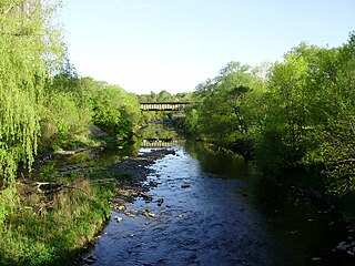
Etobicoke Creek is a river in the Greater Toronto Area of Ontario, Canada. It is a tributary of Lake Ontario and runs from Caledon to southern Etobicoke, part of the City of Toronto. The creek is within the jurisdiction of the Toronto and Region Conservation Authority.
The mayor of Mississauga is the head of Mississauga City Council and chief executive officer of the municipal government. The mayor is elected alongside city council every four years on the fourth Monday of October; there are no term limits. While in office, mayors are styled His/Her Worship.
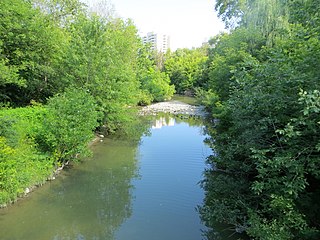
Mimico Creek is a stream that flows through Brampton, Mississauga and Toronto in the Greater Toronto Area of Ontario, Canada. It is 33 kilometres (21 mi) long, is in the Great Lakes Basin, and is a tributary of Lake Ontario.
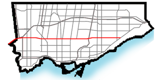
Eglinton Avenue is a major east–west arterial thoroughfare in Toronto and Mississauga in the Canadian province of Ontario. The street begins at Highway 407 at the western limits of Mississauga, as a continuation of Lower Baseline in Milton. It traverses the midsection of both cities and ends at Kingston Road. Eglinton Avenue is the only street to cross all six former boroughs of Metropolitan Toronto.
Meadowvale is a large suburban district located in the northwestern part of Mississauga, Ontario, Canada, just west of Toronto. In the 19th and early 20th centuries, Meadowvale Village in Toronto Township was established nearby and named for the meadows along the Credit River. By the 1970s the village would diminish with the current area to the west selected to be the site of a "new town" for the newly (1974) incorporated City of Mississauga and took the Meadowvale name, while "Village" was added to the historic community. This newer section comprises the bulk of the district today, and includes Lisgar, another former hamlet of which no trace remains today. Another extension of the district at Derry Road is referred to as Meadowvale West.
Hurontario Street is a roadway running in Ontario, Canada between Lake Ontario at Mississauga and Lake Huron's Georgian Bay at Collingwood. Within Peel Region, it is a major urban thoroughfare within the cities of Mississauga and Brampton, which serves as the divide from which cross-streets are split into East and West, except at its foot in the historic Mississauga neighbourhood of Port Credit. Farther north, with the exception of the section through Simcoe County, where it forms the 8th Concession, it is the meridian for the rural municipalities it passes through. In Dufferin County, for instance, parallel roads are labelled as EHS or WHS for East of Hurontario Street.
Cooksville is a neighbourhood in Mississauga in the Greater Toronto Area region of Ontario, Canada. It is centred around the intersection of Dundas Street and Hurontario Street near the eponymous Cooksville Creek.
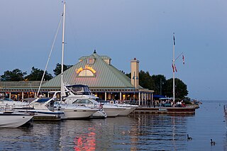
Lakeview is a neighbourhood in Mississauga in the Region of Peel, just east of Port Credit, which amalgamated into the Town of Mississauga in 1968. It is located in the extreme southeastern corner of the city, along the northern shores of Lake Ontario.
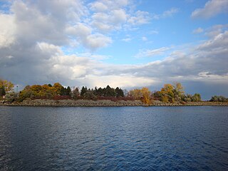
The geography of Toronto, Ontario, covers an area of 630 km2 (240 sq mi) and is bounded by Lake Ontario to the south; Etobicoke Creek, Eglinton Avenue, and Highway 427 to the west; Steeles Avenue to the north; and the Rouge River and the Scarborough–Pickering Townline to the east. In addition to Etobicoke Creek and the Rouge River, the city is trisected by two minor rivers and their tributaries, the Humber River in the west end and the Don River east of downtown. Both flow southward to Lake Ontario at Humber Bay and Toronto Harbour respectively, which are part of the longer Waterfront, as well as Etobicoke Creek and the Rouge River.
The Mississauga Transitway is a bus rapid transit (BRT) system in Mississauga, Ontario, Canada. It comprises a series of purpose-constructed bus-only roadways, as well as reserved lanes on existing city streets and portions of Highway 403, that together form a continuous 18 km (11 mi) route spanning most of the city from Winston Churchill Boulevard in the west to the junction of Highways 401 and 427 in the east on the border with Toronto. Service on the Transitway is provided by MiWay and GO Transit, with some stations providing connections to Brampton Transit and Toronto Transit Commission (TTC) bus services.
Cooksville Creek is a short stream in Mississauga, Regional Municipality of Peel in the Greater Toronto Area of Ontario, Canada. It begins near Bristol Road West and Hurontario Street and flows south to Lake Ontario at R.K McMilian Park near Lakeshore Road and Cawthra Road. The community of Cooksville is located on the west bank of the creek near Hurontario Street and Dundas Street East. The creek is surrounded mostly by residential homes and a few parks:
Dundas Street bus rapid transit is a proposed bus rapid transit (BRT) corridor proposed by Metrolinx for the western part of the Greater Toronto and Hamilton Area in Southern Ontario, Canada. It is part of the regional transportation plan The Big Move. Metrolinx currently refers to the project as Dundas bus rapid transit without the word "Street". The City of Mississauga used the brand Dundas Connects during the development phase.
The transport infrastructure and services in the Canadian city of Mississauga, Ontario include provincial highways and municipal roads, passenger and freight rail, regional and municipal bus service, and an international airport. It is interconnected with air, road, and rail transportation networks spanning the Greater Toronto Area and beyond.
Lakeshore Road is a historic roadway in the Canadian province of Ontario, running through the city of Burlington and the town of Oakville in Halton Region, as well as the city of Mississauga in Peel Region. As its name implies, the road closely follows the shoreline of Lake Ontario, although the lake itself is not visible from the road in most areas. Lakeshore Road was once a key section of the historic Highway 2, which traversed the province, but has since been downloaded to local municipalities. Despite this historical role as a major route, however, most of the road is a lower-capacity picturesque residential and historic commercial street with only two through lanes until it becomes a four-lane, higher-volume artery after it enters Mississauga and jogs to the north.