
The formation of Europe as a coherent landmass dates to after the breakup of Pangaea, taking place during the Oligocene and completed by the early Neogene period, some 20 million years ago.
The formation of Europe as a coherent landmass dates to after the breakup of Pangaea, taking place during the Oligocene and completed by the early Neogene period, some 20 million years ago.
During the Lower Paleozoic Era, Proto-Europe acquired a large piece of crust, known as East Avalonia, that would eventually become northwestern Scotland. [1] Avalonia itself would eventually separate into the eastern coastal region of North America, divided by the Atlantic Ocean, from southern Ireland, England, Wales, Belgium, and the Netherlands. [2]
Alpine orogeny started as early as the Mesozoic with the formation of the Alpide belt, some 200 Mya. [3] Even earlier orogenies relevant for the ultimate formation of Europe are the Caledonian orogeny, some 400 Mya and the Variscan orogeny, some 300 Mya.
Until the lower Oligocene period, about 32 Mya, the future lands of Europe were an island continent, separated from Asia by a shallow sea, but possessing intermittent land-bridge connections to North America via Greenland. Many animal species from the much larger North America colonized Europe during these times. As sea levels changed and sediments accumulated, the sea between Europe and Asia gradually dried out and Europe became a western appendage of the Earth's largest land mass.
The Pleistocene epoch lasted from 2.6 million years ago until 12,000 years ago. During this period there were a number of glacial and inter-glacial periods. During the glacial periods there were large drops in sea level, so the coast-line was greatly modified. The final major cold spell occurred from 25,000 to 18,000 years ago and is known as the Last Glacial Maximum when the Fenno-Scandinavian ice sheet covered much of northern Europe while the Alpine ice sheet occupied significant parts of central-southern Europe. However, there were several less cold periods after this. The epoch ends with the Younger Dryas when there were small ice sheets in Scotland and Scandinavia.
The Holocene has lasted from 12,000 years ago to the present. It can be subdivided into a number of climatic stages: Preboreal, Boreal, Atlantic, Subboreal, and Subatlantic. Its main features have been the rise in sea level and the isostatic recovery from the weight of the ice sheets in the north. This has led to flooding of the continental shelf around the British Isles and may have resulted in the Black Sea becoming saline.

The Oligocene is a geologic epoch of the Paleogene Period that extends from about 33.9 million to 23 million years before the present. As with other older geologic periods, the rock beds that define the epoch are well identified but the exact dates of the start and end of the epoch are slightly uncertain. The name Oligocene was coined in 1854 by the German paleontologist Heinrich Ernst Beyrich from his studies of marine beds in Belgium and Germany. The name comes from Ancient Greek ὀλίγος (olígos) 'few' and καινός (kainós) 'new', and refers to the sparsity of extant forms of molluscs. The Oligocene is preceded by the Eocene Epoch and is followed by the Miocene Epoch. The Oligocene is the third and final epoch of the Paleogene Period.

The Pleistocene is the geological epoch that lasted from c. 2.58 million to 11,700 years ago, spanning the Earth's most recent period of repeated glaciations. Before a change was finally confirmed in 2009 by the International Union of Geological Sciences, the cutoff of the Pleistocene and the preceding Pliocene was regarded as being 1.806 million years Before Present (BP). Publications from earlier years may use either definition of the period. The end of the Pleistocene corresponds with the end of the last glacial period and also with the end of the Paleolithic age used in archaeology. The name is a combination of Ancient Greek πλεῖστος (pleîstos) 'most' and καινός 'new'.

The Quaternary is the current and most recent of the three periods of the Cenozoic Era in the geologic time scale of the International Commission on Stratigraphy (ICS). It follows the Neogene Period and spans from 2.58 million years ago to the present. The Quaternary Period is divided into two epochs: the Pleistocene and the Holocene ; a proposed third epoch, the Anthropocene, was rejected in 2024 by IUGS, the governing body of the ICS.

Laurasia was the more northern of two large landmasses that formed part of the Pangaea supercontinent from around 335 to 175 million years ago (Mya), the other being Gondwana. It separated from Gondwana 215 to 175 Mya during the breakup of Pangaea, drifting farther north after the split and finally broke apart with the opening of the North Atlantic Ocean c. 56 Mya. The name is a portmanteau of Laurentia and Asia.

The Tethys Ocean, also called the Tethys Sea or the Neo-Tethys, was a prehistoric ocean during much of the Mesozoic Era and early-mid Cenozoic Era. It was the predecessor to the modern Indian Ocean, the Mediterranean Sea, and the Eurasian inland marine basins.

The Wisconsin glaciation, also called the Wisconsin glacial episode, was the most recent glacial period of the North American ice sheet complex, peaking more than 20,000 years ago. This advance included the Cordilleran Ice Sheet, which nucleated in the northern North American Cordillera; the Innuitian ice sheet, which extended across the Canadian Arctic Archipelago; the Greenland ice sheet; and the massive Laurentide Ice Sheet, which covered the high latitudes of central and eastern North America. This advance was synchronous with global glaciation during the last glacial period, including the North American alpine glacier advance, known as the Pinedale glaciation. The Wisconsin glaciation extended from about 75,000 to 11,000 years ago, between the Sangamonian Stage and the current interglacial, the Holocene. The maximum ice extent occurred about 25,000–21,000 years ago during the last glacial maximum, also known as the Late Wisconsin in North America.

The geology of Great Britain is renowned for its diversity. As a result of its eventful geological history, Great Britain shows a rich variety of landscapes across the constituent countries of England, Wales and Scotland. Rocks of almost all geological ages are represented at outcrop, from the Archaean onwards.

The Last Glacial Period (LGP), also known as the Last glacial cycle, occurred from the end of the Last Interglacial to the beginning of the Holocene, c. 115,000 – c. 11,700 years ago, and thus corresponds to most of the timespan of the Late Pleistocene.
The Quaternary glaciation, also known as the Pleistocene glaciation, is an alternating series of glacial and interglacial periods during the Quaternary period that began 2.58 Ma and is ongoing. Although geologists describe this entire period up to the present as an "ice age", in popular culture this term usually refers to the most recent glacial period, or to the Pleistocene epoch in general. Since Earth still has polar ice sheets, geologists consider the Quaternary glaciation to be ongoing, though currently in an interglacial period.

The geology of the Rocky Mountains is that of a discontinuous series of mountain ranges with distinct geological origins. Collectively these make up the Rocky Mountains, a mountain system that stretches from Northern British Columbia through central New Mexico and which is part of the great mountain system known as the North American Cordillera.

The geology of England is mainly sedimentary. The youngest rocks are in the south east around London, progressing in age in a north westerly direction. The Tees–Exe line marks the division between younger, softer and low-lying rocks in the south east and the generally older and harder rocks of the north and west which give rise to higher relief in those regions. The geology of England is recognisable in the landscape of its counties, the building materials of its towns and its regional extractive industries.

The geological history of the Earth follows the major geological events in Earth's past based on the geological time scale, a system of chronological measurement based on the study of the planet's rock layers (stratigraphy). Earth formed about 4.54 billion years ago by accretion from the solar nebula, a disk-shaped mass of dust and gas left over from the formation of the Sun, which also created the rest of the Solar System.

The Paratethys sea, Paratethys ocean, Paratethys realm or just Paratethys was a large shallow inland sea that stretched from the region north of the Alps over Central Europe to the Aral Sea in Central Asia.

West Virginia's geologic history stretches back into the Precambrian, and includes several periods of mountain building and erosion. At times, much of what is now West Virginia was covered by swamps, marshlands, and shallow seas, accounting for the wide variety of sedimentary rocks found in the state, as well as its wealth of coal and natural gas deposits. West Virginia has had no active volcanism for hundreds of millions of years, and does not experience large earthquakes, although smaller tremors are associated with the Rome Trough, which passes through the western part of the state.
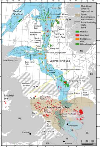
The geology of the North Sea describes the geological features such as channels, trenches, and ridges today and the geological history, plate tectonics, and geological events that created them.
The geology of Saskatchewan can be divided into two main geological regions, the Precambrian Canadian Shield and the Phanerozoic Western Canadian Sedimentary Basin. Within the Precambrian shield exists the Athabasca sedimentary basin. Meteorite impacts have altered the natural geological formation processes. The prairies were most recently affected by glacial events in the Quaternary period.
A paleocontinent or palaeocontinent is a distinct area of continental crust that existed as a major landmass in the geological past. There have been many different landmasses throughout Earth's time. They range in sizes; some are just a collection of small microcontinents while others are large conglomerates of crust. As time progresses and sea levels rise and fall more crust can be exposed making way for larger landmasses. The continents of the past shaped the evolution of organisms on Earth and contributed to the climate of the globe as well. As landmasses break apart, species are separated and those that were once the same now have evolved to their new climate. The constant movement of these landmasses greatly determines the distribution of organisms on Earth's surface. This is evident with how similar fossils are found on completely separate continents. Also, as continents move, mountain building events (orogenies) occur, causing a shift in the global climate as new rock is exposed and then there is more exposed rock at higher elevations. This causes glacial ice expansion and an overall cooler global climate. The movement of the continents greatly affects the overall dispersal of organisms throughout the world and the trend in climate throughout Earth's history. Examples include Laurentia, Baltica and Avalonia, which collided together during the Caledonian orogeny to form the Old Red Sandstone paleocontinent of Laurussia. Another example includes a collision that occurred during the late Pennsylvanian and early Permian time when there was a collision between the two continents of Tarimsky and Kirghiz-Kazakh. This collision was caused because of their askew convergence when the paleoceanic basin closed.

New England is a region in the North Eastern United States consisting of the states Rhode Island, Connecticut, Massachusetts, New Hampshire, Vermont, and Maine. Most of New England consists geologically of volcanic island arcs that accreted onto the eastern edge of the Laurentian Craton in prehistoric times. Much of the bedrock found in New England is heavily metamorphosed due to the numerous mountain building events that occurred in the region. These events culminated in the formation of Pangaea; the coastline as it exists today was created by rifting during the Jurassic and Cretaceous periods. The most recent rock layers are glacial conglomerates.

The geology of Massachusetts includes numerous units of volcanic, intrusive igneous, metamorphic and sedimentary rocks formed within the last 1.2 billion years. The oldest formations are gneiss rocks in the Berkshires, which were metamorphosed from older rocks during the Proterozoic Grenville orogeny as the proto-North American continent Laurentia collided against proto-South America. Throughout the Paleozoic, overlapping the rapid diversification of multi-cellular life, a series of six island arcs collided with the Laurentian continental margin. Also termed continental terranes, these sections of continental rock typically formed offshore or onshore of the proto-African continent Gondwana and in many cases had experienced volcanic events and faulting before joining the Laurentian continent. These sequential collisions metamorphosed new rocks from sediments, created uplands and faults and resulted in widespread volcanic activity. Simultaneously, the collisions raised the Appalachian Mountains to the height of the current day Himalayas.
The Late Cenozoic Ice Age, or Antarctic Glaciation, began 34 million years ago at the Eocene-Oligocene Boundary and is ongoing. It is Earth's current ice age or icehouse period. Its beginning is marked by the formation of the Antarctic ice sheets.