Georgia State Route 63

Last updated

Georgia 63.svg

State Route 63
Georgia state route 63 map.png
Route information
Maintained by Georgia Department of Transportation
Length 23.1 mi [1] (37.2 km)
Major junctions
South endGeorgia 59.svg SR 59 northeast of Commerce, Georgia
 I-85.svg I85 northeast of Commerce
North endUS 123.svgGeorgia 106.svgGeorgia 184.svgGeorgia 365.svg US 123 / SR 106 / SR 184 / SR 365 in Toccoa
Location
Counties Banks, Franklin, Stephens
Highway system
  • Georgia State Routes
Georgia 62.svg SR 62 SR 64 Georgia 64.svg

State Route 63 (SR 63) is a 23.1-mile-long (37.2 km) state highway in the northeastern part of the U.S. state of Georgia. It and SR 59 serve to connect Commerce and Toccoa.

Northeast Georgia

Northeast Georgia is a region of Georgia in the United States. The northern part is also in the north Georgia mountains, while the southern part is still hilly but much flatter in topography. Northeast Georgia is also served by the Asheville/Spartanburg/Greenville/Anderson market.

U.S. state constituent political entity of the United States

In the United States, a state is a constituent political entity, of which there are currently 50. Bound together in a political union, each state holds governmental jurisdiction over a separate and defined geographic territory and shares its sovereignty with the federal government. Due to this shared sovereignty, Americans are citizens both of the federal republic and of the state in which they reside. State citizenship and residency are flexible, and no government approval is required to move between states, except for persons restricted by certain types of court orders. Four states use the term commonwealth rather than state in their full official names.

Georgia (U.S. state) State of the United States of America

Georgia is a state in the Southeastern United States. It began as a British colony in 1733, the last and southernmost of the original Thirteen Colonies to be established. Named after King George II of Great Britain, the Province of Georgia covered the area from South Carolina south to Spanish Florida and west to French Louisiana at the Mississippi River. Georgia was the fourth state to ratify the United States Constitution, on January 2, 1788. In 1802–1804, western Georgia was split to the Mississippi Territory, which later split to form Alabama with part of former West Florida in 1819. Georgia declared its secession from the Union on January 19, 1861, and was one of the original seven Confederate states. It was the last state to be restored to the Union, on July 15, 1870. Georgia is the 24th largest and the 8th most populous of the 50 United States. From 2007 to 2008, 14 of Georgia's counties ranked among the nation's 100 fastest-growing, second only to Texas. Georgia is known as the Peach State and the Empire State of the South. Atlanta, the state's capital and most populous city, has been named a global city. Atlanta's metropolitan area contains about 55% of the population of the entire state.

Contents

Route description

SR 63 begins at an intersection with SR 59, northeast of Commerce. The route travels north-northeastward toward Toccoa. About 1,000 feet (300 m) after its southern terminus, SR 63 has an interchange with Interstate 85 (I-85) in rural Banks County. SR 63 continues to the north-northeast. It has intersections with SR 51, SR 198, and SR 184. The highway crosses the northwestern corner of Franklin County and enters Stephens County. SR 63 intersects SR 106 just north of the Franklin–Stephens county line. The two highways form a concurrency to the north-northeast. On the way to Toccoa, the route has an intersection with SR 17. Just before entering Toccoa, SR 63 has an intersection with SR 145 before traveling northwest and curve to the north until it meets its northern terminus, an intersection with US 123/SR 184/SR 365 in downtown Toccoa. This intersection also marks the northern terminus of SR 106. [1]

Intersection (road) A road junction where two or more roads either meet or cross at grade

An intersection is an at-grade junction where two or more roads meet or cross. Intersections may be classified by number of road segments, traffic controls, and/or lane design.

Georgia State Route 59 highway in Georgia

State Route 59 (SR 59) is a 32.3-mile-long (52.0 km) state highway that runs southwest-to-northeast through portions of Jackson, Banks, Franklin, and Hart counties in the northeastern part of the U.S. state of Georgia. The route connects Commerce with SR 77 near the shore of Lake Hartwell. The highway passes through Carnesville and Lavonia. It closely parallels Interstate 85 (I-85).

Commerce, Georgia City in Georgia, United States

Commerce is a city in Jackson County, Georgia, United States, 70 miles (110 km) northeast of Atlanta. As of the 2010 census, the city had a population of 6,544.

SR 63 is not part of the National Highway System, a system of roadways important to the nation's economy, defense, and mobility. [2]

National Highway System (United States) highway system in the United States

The National Highway System (NHS) is a network of strategic highways within the United States, including the Interstate Highway System and other roads serving major airports, ports, rail or truck terminals, railway stations, pipeline terminals and other strategic transport facilities. Altogether, it constitutes the largest highway system in the world.

Major intersections

CountyLocationmi [1] kmDestinationsNotes
Banks 0.00.0Georgia 59.svg SR 59  Commerce, Carnesville Southern terminus
0.20.32I-85.svg I85 (SR 403) Atlanta, Greenville I-85 exit 154
5.99.5Georgia 51.svg SR 51  Homer, Carnesville
7.712.4Georgia 198.svg SR 198  Carnesville
9.815.8 Middle Fork Broad River
10.416.7Georgia 184.svg SR 184 north Toccoa Southern terminus of SR 184
Franklin
No major junctions
Stephens Mize 14.924.0Georgia 106.svg SR 106 south Carnesville Southern end of SR 106 concurrency
18.129.1 North Fork Broad River
19.531.4Georgia 17.svg SR 17 (Toccoa Bypass) Clarkesville, Lavonia
21.334.3Georgia 145.svg SR 145 south Carnesville Northern terminus of SR 145
Toccoa 23.137.2US 123.svgGeorgia 365.svgGeorgia 184.svgGeorgia 106.svg US 123 / SR 365 (Currahee Street) / SR 184 (Broad Street) / SR 106 south Clarkesville, Westminster Northern terminus; northern end of SR 106 concurrency
1.000 mi = 1.609 km; 1.000 km = 0.621 mi

See also

Related Research Articles

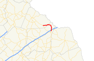
U.S. Route 123 is a spur of US 23 in the U.S. states of Georgia and South Carolina. The U.S. Highway runs 75.12 miles (120.89 km) from US 23, US 441, and SR 365 near Clarkesville, Georgia, north and east to Interstate 385 Business in Greenville, South Carolina. US 123 parallels I-85 to the north as it connects the Northeast Georgia cities of Clarkesville and Toccoa with the western Upstate South Carolina communities of Westminster, Seneca, Clemson, Easley, and Greenville.

Georgia State Route 54 highway in Georgia

State Route 54 (SR 54) is a 70.5-mile-long (113.5 km) state highway that runs southwest-to-northeast through portions of Troup, Meriwether, Coweta, Fayette, Clayton, and Fulton counties in the northwestern part of the U.S. state of Georgia. The route connects Hogansville with Atlanta, via Peachtree City, Fayetteville, Jonesboro, and Forest Park.

Georgia State Route 14 highway in Georgia

State Route 14 (SR 14) is a 87.4-mile-long (140.7 km) state highway that travels southwest-to-northeast through portions of Troup, Coweta, and Fulton counties in the west-central and north-central parts of the U.S. state of Georgia. The highway connects the Alabama state line in West Point to Downtown Atlanta, via LaGrange, Fairburn, College Park, and East Point. Except for the northernmost segment, it is entirely concurrent with U.S. Route 29 (US 29).

Georgia State Route 34 highway in Georgia

State Route 34 (SR 34) is a 43.6-mile-long (70.2 km) state highway that travels west-to-east through portions of Heard and Coweta counties in the west-central part of the U.S. state of Georgia. The highway connects the Alabama state line southwest of Franklin with the Peachtree City area, via Franklin and Newnan.

Georgia State Route 164 highway in Georgia

State Route 164 (SR 164) is a state highway in the northeastern part of the U.S. state of Georgia. It is entirely within Banks County.

Georgia State Route 365 highway in Georgia

State Route 365 (SR 365) is a 69.5-mile-long (111.8 km) state highway that travels within portions of Gwinnett, Hall, Habersham, and Stephens counties. It begins at exit 113 on Interstate 85 (I-85), at the southeastern edge of Suwanee. This is also the southern terminus of I-985. It continues from that point concurrent with I-985 for the entire length of that freeway. Eventually, U.S. Route 23 (US 23) also joins the concurrency. The highway heads northeast through Gainesville and Toccoa, before it terminates at the South Carolina state line, southwest of Westminster, South Carolina.

Georgia State Route 334 highway in Georgia

State Route 334 (SR 334) is a 12.4-mile-long (20.0 km) south-to-north state highway located entirely within Jackson County in the northeastern part of the U.S. state of Georgia. It travels from north of Athens to Commerce. It is effectively an alternate route of U.S. Route 441 (US 441).

Georgia State Route 328 highway in Georgia

State Route 328 (SR 328) is an arc-shaped 9.8-mile-long (15.8 km) state highway in the northeast part of the U.S. state of Georgia. The route connects Avalon and Lavonia and provides access to Lake Hartwell and Tugaloo State Park. It is known as Gumlog Road for its entire length. It has been called Gumlog Road long before G-dot gave it a dreary number.

Georgia State Route 327 highway in Georgia

State Route 327 (SR 327) is a 9.8-mile-long (15.8 km) north-south state highway that is located entirely in Franklin County in the northeast part of the U.S. state of Georgia.

Georgia State Route 326 highway in Georgia

State Route 326 (SR 326) is a 16.4-mile-long (26.4 km) southwest-to-northeast state highway located mostly in rural areas of the northeastern part of the U.S. state of Georgia. Its route travels within portions of Jackson, Banks, and Franklin counties.

Georgia State Route 320 highway in Georgia

State Route 320 (SR 320) is a 9.9-mile-long (15.9 km) north-south state highway in the northeastern part of the U.S. state of Georgia. It is located in rural areas, almost all of it in Franklin County, and a very small segment in Stephens County.

Georgia State Route 17 highway in Georgia

State Route 17 (SR 17) is a 294-mile-long (473 km) state highway that travels south-to-north through portions of Chatham, Effingham, Screven, Jenkins, Burke, Jefferson, Warren, McDuffie, Wilkes, Elbert, Hart, Franklin, Stephens, Habersham, White, and Towns counties in the east-central and northeastern parts of the U.S. state of Georgia. The highway connects Interstate 16 (I-16) in Bloomingdale to the North Carolina state line, northwest of Hiawassee, via Millen, Louisville, Wrens, Thomson, Washington, Elberton, Royston, Toccoa, Clarkesville, and Hiawassee.

Georgia State Route 77 highway in Georgia

State Route 77 is a 103-mile-long (166 km) state highway that runs nouth-to-sorth through portions of Hancock, Greene, Oglethorpe County, Elbert, and Hart Counties in the eastern part of the State of Georgia.

Georgia State Route 281 highway in Georgia

State Route 281 (SR 281) is a south-north state highway located in the northeastern part of the U.S. state of Georgia. Its route is in Madison and Franklin Counties, with a brief section straddling the Madison-Hart County line.

Georgia State Route 106 highway in Georgia

State Route 106 (SR 106) is a 45.2-mile-long (72.7 km) state highway that runs south-to-north through portions of Madison, Franklin, and Stephens counties in the northeastern part of the U.S. state of Georgia.

Georgia State Route 116 highway in Georgia

State Route 116 (SR 116) is a 30.7-mile-long (49.4 km) state highway that runs west-to-east through portions of Harris and Talbot counties in the west-central part of the U.S. state of Georgia.

Georgia State Route 105 highway in Georgia

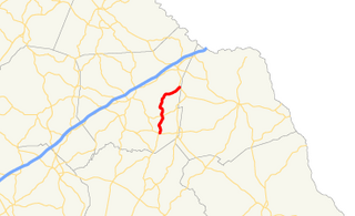
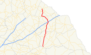
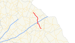
State Route 105 (SR 105) is a 23.1-mile-long (37.2 km) state highway in the northeastern part of the U.S. state of Georgia. The highway begins at the Banks–Franklin–Stephens county tripoint, east-southeast of Baldwin. It ends at Harvest, which is west-northwest of Clarkesville.

Georgia State Route 184 highway in Georgia

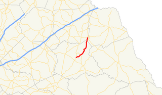
State Route 184 (SR 184) is a 19.4-mile (31.2 km) state highway that runs south-to-north through portions of Banks and Stephens counties in the northeastern part of the U.S. state of Georgia. The route's southern terminus is at SR 63 in northeastern Banks County. The northern terminus at the Tugaloo River and the South Carolina state line where the road continues as Cleveland Pike Road.

Georgia State Route 145 highway in Georgia

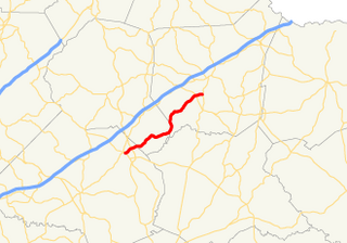
State Route 145 (SR 145) is a 24.3-mile-long (39.1 km) state highway that runs southeast-to-northwest through portions of Franklin and Stephens counties in the northeastern part of the U.S. state of Georgia. The route connects Franklin Springs with Toccoa.

References

  1. 1 2 3 Google (July 30, 2013). "Route of SR 63" (Map). Google Maps . Google. Retrieved July 30, 2013.
  2. "National Highway System: Georgia" (PDF). United States Department of Transportation. October 1, 2012. Retrieved July 30, 2013.

Route map: Google

KML file (edithelp)
KML is from Wikidata