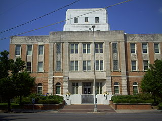
Coffee County is a county located in the southeastern part of the U.S. state of Alabama. As of the 2010 census, the population was 49,948. Its county seat is Elba. Its name is in honor of General John Coffee.

Dale County is a county located in the southeastern part of the U.S. state of Alabama. As of the 2010 census the population was 50,251. Its county seat and largest city is Ozark. Its name is in honor of General Samuel Dale.

Henry County is a county in the southeastern part of the U.S. state of Alabama. As of the 2010 census, its population was 17,302. Its county seat is Abbeville. The county was named for Patrick Henry (1736–1799), famous orator and Governor of Virginia.

Lauderdale County is a county located on the eastern border of the U.S. state of Mississippi. As of the 2010 census, the population was 80,261. The county seat is Meridian. The county is named for Colonel James Lauderdale, who was killed at the Battle of New Orleans in the War of 1812.

Greenville is a city in Butler County, Alabama, United States. At the 2010 census, the population was 8,135. The city is the county seat of Butler County and is known as the Camellia City. The movement to change the official Alabama state flower from the goldenrod to the camellia originated in Greenville with legislative sponsors LaMont Glass and H.B. Taylor.

Midland City is a town in Dale County, Alabama, United States. At the 2010 U.S. Census the population was 2,344. It incorporated in 1890. It is part of the Ozark Micropolitan Statistical Area.

Columbia is a town in Houston County, Alabama, United States. It is part of the Dothan, Alabama Metropolitan Statistical Area. At the 2010 census the population was 740, down from 804 in 2000.

The Wiregrass Region—or Wiregrass Country—is an area of the Southern United States encompassing parts of southern Georgia, southeastern Alabama, and the Florida Panhandle. The region is named for the native Aristida stricta, commonly known as wiregrass due to its texture.

The Manchester, Buxton, Matlock and Midland Junction Railway ran from a junction with the Midland Railway at Ambergate to Rowsley north of Matlock and thence to Buxton.
Oliver Cicero Wiley was a U.S. Representative from Alabama, brother of Ariosto Appling Wiley.

The Enterprise–Ozark Micropolitan Statistical Area, as defined by the United States Census Bureau, was an area consisting of two counties in southeastern Alabama, anchored by the cities of Enterprise and Ozark. As of the 2000 census, the μSA had a population of 92,744.

The following outline is provided as an overview of and topical guide to the U.S. state of Alabama:

On January 29, 2013, a hostage crisis, lasting almost seven days, began in the Wiregrass Region near U.S. Highway 231 in Midland City, Alabama. Jimmy Lee Dykes, a 65-year-old Vietnam War-era veteran, boarded a Dale County school bus, killed the driver, and took a five-year-old boy hostage. On the afternoon of February 4, law enforcement agents entered the bunker, killed Dykes, and rescued the child.

The 1976 United States presidential election in Alabama took place on November 2, 1976, as part of the 1976 presidential election. Voters chose nine representatives, or electors, to the Electoral College, who voted for president and vice president.

Barnes, also known as Barnes Cross Roads or Burns, is an unincorporated community in Dale County, Alabama, United States. Barnes is located on Alabama State Route 123, 4.6 miles (7.4 km) south-southeast of Ariton.

Echo, also known as Marshalls Cross Roads, is an unincorporated community in Dale County, Alabama, United States. Echo is located on Alabama State Route 27, 10.4 miles (16.7 km) east of Ozark.

Ewell is an unincorporated community in Dale County, Alabama, United States. Ewell is located on Alabama State Route 27, 3.0 miles (4.8 km) southeast of Ozark.
State Route 605 (SR 605) is a 23.420-mile-long (37.691 km) state highway in Houston and Dale counties in the southeastern part of the U.S. state of Alabama. The southern terminus of the highway is at an intersection with U.S. Route 231 (US 231) south of Madrid. The northern terminus of the route is at another intersection with US 231 in Midland City.
State Route 134 is an east-west state route located in Covington, Coffee, Dale, Henry, and Houston counties in Alabama. It loosely parallels U.S. Route 84 (US 84) between Opp and the Chattahoochee River.


