Related Research Articles

The history of Antarctica emerges from early Western theories of a vast continent, known as Terra Australis, believed to exist in the far south of the globe. The term Antarctic, referring to the opposite of the Arctic Circle, was coined by Marinus of Tyre in the 2nd century AD.

Victoria Land is a region in eastern Antarctica which fronts the western side of the Ross Sea and the Ross Ice Shelf, extending southward from about 70°30'S to 78°00'S, and westward from the Ross Sea to the edge of the Antarctic Plateau. It was discovered by Captain James Clark Ross in January 1841 and named after Queen Victoria. The rocky promontory of Minna Bluff is often regarded as the southernmost point of Victoria Land, and separates the Scott Coast to the north from the Hillary Coast of the Ross Dependency to the south.
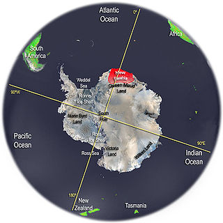
New Swabia was a disputed Antarctic claim by Nazi Germany within the Norwegian territorial claim of Queen Maud Land and is now a cartographic name sometimes given to an area of Antarctica between 20°E and 10°W in Queen Maud Land. New Swabia was explored by Germany in early 1939 and named after that expedition's ship, Schwabenland, itself named after the German region of Swabia.

Marie Byrd Land (MBL) is an unclaimed region of Antarctica. With an area of 1,610,000 km2 (620,000 sq mi), it is the largest unclaimed territory on Earth. It was named after the wife of American naval officer Richard E. Byrd, who explored the region in the early 20th century.

Terra Nova was a whaler and polar expedition ship. She is best known for carrying the 1910 British Antarctic Expedition, Robert Falcon Scott's last expedition.
BGR may refer to:
Oates Land is a region of Antarctica. It is variously defined as a portion of the East Antarctica near the coast stretching along and inland from the Oates Coast and as an officially delineated wedge-shaped segment of the Australian Antarctic Territory. The segment of the Australian claim extends between 153°45' E and 160° E, forming a wedge between Latitude 60° S and the South Pole. It is bounded in the east by the Ross Dependency and overlaps George V Land to the west.

Cape Adare is a prominent cape of black basalt forming the northern tip of the Adare Peninsula and the north-easternmost extremity of Victoria Land, East Antarctica.
Richard H. Weyl was a German geologist and noted author on the subject of Central American Geology.
The Transglobe Expedition (1979–1982) was the first expedition to make a longitudinal (north–south) circumnavigation of the Earth using only surface transport. British adventurer Sir Ranulph Fiennes led a team, including Oliver Shepard and Charles R. Burton, that attempted to follow the Greenwich meridian over both land and water. They began in Greenwich in the United Kingdom in September 1979 and travelled south, arriving at the South Pole on 15 December 1980. Over the next 14 months, they travelled north, reaching the North Pole on 11 April 1982. Travelling south once more, they arrived again in Greenwich on 29 August 1982. It required traversing both of the poles and the use of boats in some places. Oliver Shepard took part in the Antarctic leg of the expedition. Ginny Fiennes handled all communications between the land team and their support, and ran the polar bases.

Commander Harry Lewin Lee Pennell was a Royal Navy officer who served on the Terra Nova Expedition. He was responsible for the first sighting of Oates Coast on 22 February 1911, and named it after Captain Lawrence Oates. He only spent short periods in Antarctica, returning with the Terra Nova to wait out the winters of 1911 and 1912 in Lyttelton, New Zealand. Due to the absence of Robert Falcon Scott on land, Pennell assumed the role of command on the Terra Nova, which would bring fresh supplies back to Antarctica with each voyage.

Tourism in Antarctica started by the sea in the 1960s. Air overflights of Antarctica started in the 1970s with sightseeing flights by airliners from Australia and New Zealand, and were resumed in the 1990s. The (summer) tour season lasts from November to March. Most of the estimated 14,762 visitors to Antarctica from 1999–2000 were on sea cruises. During the 2009 to 2010 tourist season, over 37,000 people visited Antarctica.

The Afrin River (Arabic: نهر عفرين Nahr ʻIfrīn; is a tributary of the Orontes River in Turkey and Syria. It rises in the Kartal Mountains in Gaziantep Province, Turkey, flows south through the city of Afrin in Syria, then reenters Turkey. It joins the Karasu at the site of the former Lake Amik, and its waters flow to the Orontes by a canal.
Wunsiedel Marble is a group of metamorphic carbonate rocks, which were, and are, mainly extracted in the German town Wunsiedel at several quarries. This Upper Franconian calcite marble occurs both in this region and beyond, particularly in Bavaria. It is found in a northern band and southern band.
Mount Dockery is a mountain, 1,095 m (3,590 ft) high, standing 6 km (4 mi) west of Mount Matthias in the western part of the Everett Range in the Concord Mountains of northern Victoria Land, Antarctica. It stands on the Pennell Coast, between Cape Williams and Cape Adare.

Pennell Coast is that portion of the coast of Antarctica between Cape Williams and Cape Adare. To the west of Cape Williams lies Oates Coast, and to the east and south of Cape Adare lies Borchgrevink Coast. Named by New Zealand Antarctic Place-Names Committee (NZ-APC) in 1961 after Lieutenant Harry Pennell, Royal Navy, commander of the Terra Nova, the expedition ship of the British Antarctic Expedition, 1910–13. Pennell engaged in oceanographic work in the Ross Sea during this period. In February 1911 he sailed along this coast in exploration and an endeavor to land the Northern Party led by Lieutenant Victor Campbell.
The Federal Institute for Geosciences and Natural Resources is a German agency within the Federal Ministry of Economics and Technology. It acts as a central geoscience consulting institution for the German federal government. The headquarters of the agency is located in Hanover and there is a branch in Berlin. Early 2013, the BGR employed a total of 795 employees. The BGR, the State Authority for Mining, Energy and Geology and the Leibniz Institute for Applied Geophysics form the Geozentrum Hanover. All three institutions have a common management and infrastructure, and complement each other through their interdisciplinary expertise.

Laura Crispini is an Italian geologist and an Antarctic researcher. Her areas of expertise are for the Tectonics, Geodynamics and Geological Mapping including the Geology of Antarctica. She has been nominated among 150 International representative of female Antarctic researchers for the SCAR "Celebration of Women in Antarctic Research" wikibomb event. At present she is Professor at the University of Genoa at the Department for Earth Sciences, Envinronment and life (DISTAV).
References
- ↑ Kothe, Jürgen; et al. (1981). GANOVEX, German Antarctic North Victoria Land Expedition, 1979/1980. Hannover: Bundesanstalt für Geowissenschaften und Rohstoffe und den Geologischen Landesämtern in der Bundesrepublik Deutschland.
- 1 2 "Antarctic expedition GANOVEX VIII". BGR. Archived from the original on 2014-01-11. Retrieved 2014-01-11.
- ↑ "Antarkitsexpedition GANOVEX XI" (in German). BGR. Retrieved 2019-03-07.
| General | |
|---|---|
| National libraries | |
| | This Victoria Land location article is a stub. You can help Wikipedia by expanding it. |