Gersloot Gersleat | |
|---|---|
Village | |
 Bell tower | |
 Coat of arms | |
 Location in Heerenveen municipality | |
 Gersloot Location in the Netherlands  Gersloot Gersloot (Netherlands) | |
| Coordinates: 53°0′23″N5°57′51″E / 53.00639°N 5.96417°E | |
| Country | |
| Province | |
| Municipality | |
| Area | |
• Total | 1.48 km2 (0.57 sq mi) |
| Elevation | −0.8 m (−2.6 ft) |
| Population (2021) [1] | |
• Total | 105 |
| • Density | 70.9/km2 (184/sq mi) |
| Postal code | 8457 [1] |
| Dialing code | 0513 |
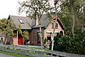
Gersloot (West Frisian : Gersleat) is a village in Heerenveen in the province of Friesland, the Netherlands.
Contents
The village was first mentioned in 1281 as Gerslach and means tapered ditch. [3] It used to have a church, but it was demolished in 1735, and only the bell tower remains. In 1840, it was home to 146 people. [4] Before 1934, Gersloot was part of the Aengwirden municipality. [4]