Oudeschoot

Last updated
Oudeschoot
Aldskoat
Village
Oudeschoot, kapel foto1 2011-05-21 17.01.JPG
Oudeschoot, chapel: Skoattertsjerke
Oudeschoot vlag.svg
Oudeschoot wapen.svg
Oudeschoot-OpenTopo.jpg
Map of Oudeschoot
2010-NL-P02-Fryslan-positiekaart-gemnamen.jpg
Red pog.svg
Oudeschoot
Location in the Netherlands
Netherlands location map.svg
Red pog.svg
Oudeschoot
Oudeschoot (Netherlands)
Coordinates: Coordinates: 52°56′5″N5°57′17″E / 52.93472°N 5.95472°E / 52.93472; 5.95472
Country Flag of the Netherlands.svg Netherlands
Province Frisian flag.svg Friesland
Municipality Heerenveen flag.svg Heerenveen
Area
[1]
  Total3.72 km2 (1.44 sq mi)
Elevation
[2]
2 m (7 ft)
Population
 (2021) [1]
  Total1,500
  Density400/km2 (1,000/sq mi)
Postal code
8451 [1]
Dialing code 0513

Oudeschoot (West Frisian : Aldskoat) is a village in Heerenveen in the province of Friesland, the Netherlands. It had a population of around 1,580 in January 2017. [3]

Contents

History

The village was first mentioned in 1299 as van Scoeten. The name means "corner of higher land". Oude (old) has been added to distinguish between Nieuweschoot. In 1299, a nunnery of the German order was founded in Oudeschoot, and has existed until 1580. [4] Oudeschoot used to be the capital of the grietenij (predecessor of a municipality) Schoterland  [ nl ] until 1934. In 1828, the main road from Leeuwarden to Zwolle was built through the village, and was later joined by a railway line. [5] Since 1600, the Skoattermerk, an annual market is held on the second day of Pentecost, and is the oldest extant market in the northern provinces. [6]

The Dutch Reformed church was built in 1752. [5] In 1840, it was home to 452 people. [6] Julia Jan Woutersstichting is a retirement home which was built in 1901 on the grounds of the 1763 manor house Veenwijk. The home is built in Renaissance Revival style and is surrounded by a large park. [5]

Before 1934, Oudeschoot was part of the Schoterland municipality. [6] In 1965, a large part of the village was annexed by Heerenveen. [6]

Related Research Articles

Akkrum Village in Friesland, Netherlands

Akkrum is a village in the Dutch province of Friesland. It is located in the municipality Heerenveen, about 17 km south of the city of Leeuwarden.
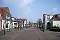
Britsum Village in Friesland, Netherlands

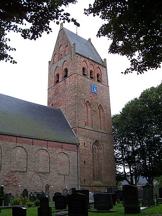
The village of Britsum is located in the municipality of Leeuwarden, in the Netherlands. Britsum was built on an artificial bank (terp) running along the eastern side of the former Middelzee. The church, built around 1300, is also located on this bank. It had a population of about 910 citizens in January 2017.

Aldeboarn Village in Friesland, Netherlands

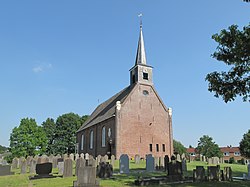
Aldeboarn is a village in Heerenveen in the province of Friesland, the Netherlands. It had a population of around 1545 in January 2017. Aldeboarn has an iconic church tower.

Delfstrahuizen Village in Friesland, Netherlands

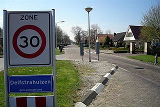
Delfstrahuizen is a small village in De Fryske Marren in the province of Friesland, the Netherlands. It had a population of around 380 including the surrounding area in 2017.

Jubbega Village in Friesland, Netherlands

Jubbega is a village in the municipality of Heerenveen in the province of Friesland, the Netherlands. It had a population of around 3275 in January 2017.

Nieuwehorne Village in Friesland, Netherlands

Nieuwehorne is a village in Heerenveen in the province of Friesland, the Netherlands. It had a population of around 1,450 in January 2017.

Oudehorne Village in Friesland, Netherlands

Oudehorne is a village in Heerenveen in the province of Friesland, the Netherlands. It had a population of around 835 in January 2017.

Hoornsterzwaag Village in Friesland, Netherlands

Hoornsterzwaag is a small village in Heerenveen in the province of Friesland, the Netherlands. It had a population of around 830 in January 2017.

Tjalleberd Village in Friesland, Netherlands

Tjalleberd is a village in Heerenveen in the province of Friesland, the Netherlands. It had a population of around 820 in January 2017.

Mildam Village in Friesland, Netherlands

Mildam is a village in Heerenveen in the province of Friesland, the Netherlands. It had a population of around 685 in January 2017.

Katlijk Village in Friesland, Netherlands

Katlijk is a village in Heerenveen in the province of Friesland, the Netherlands. It had a population of around 610 in 2017.

Luinjeberd Village in Friesland, Netherlands

Luinjeberd is a village in the Heerenveen municipality in the province of Friesland, the Netherlands. It had a population of around 430 in January 2017.

Nieuweschoot Village in Friesland, Netherlands

Nieuweschoot is a village in Heerenveen in the province of Friesland, the Netherlands. It had a population of around 185 in January 2017.

Terband Village in Friesland, Netherlands

Terband is a village in Heerenveen in the province of Friesland, the Netherlands. It had a population of around 270 in January 2017.

Hijum Village in Friesland, Netherlands

Hijum is a village in Leeuwarden municipality in the province of Friesland, the Netherlands. It had a population of around 385 in January 2017.

Nijehaske Neighbourhood and village in Friesland, Netherlands

Nijehaske is a village in De Fryske Marren municipality, west of Heerenveen in the province of Friesland, the Netherlands. It had a population of around 55 in 2017. In 1934, most of Nijehaske was transferred to Heerenveen and has become a neighbourhood.

Oudehaske Village in Friesland, Netherlands

Oudehaske is a village in De Fryske Marren in the province of Friesland, the Netherlands. It had a population of around 1980 in 2017.

Rotsterhaule Village in Friesland, Netherlands

Rotsterhaule is a village in De Fryske Marren municipality in the province of Friesland, the Netherlands. It had a population of around 565 in 2017.

Rohel Village in Friesland, Netherlands

Rohel is a village in De Fryske Marren municipality in the province of Friesland, the Netherlands. It had a population of around 270 in 2017.

Sintjohannesga Village in Friesland, Netherlands

Sintjohannesga is a village in De Fryske Marren municipality in the province of Friesland, the Netherlands. It had a population of around 1280 in 2017.

References

  1. 1 2 3 "Kerncijfers wijken en buurten 2021". Central Bureau of Statistics. Retrieved 30 March 2022.
  2. "Postcodetool for 8451BA". Actueel Hoogtebestand Nederland (in Dutch). Het Waterschapshuis. Retrieved 30 March 2022.
  3. Kerncijfers wijken en buurten 2017 - CBS Statline
  4. "Oudeschoot - (geografische naam)". Etymologiebank (in Dutch). Retrieved 30 March 2022.
  5. 1 2 3 Ronald Stenvert & Sabine Broekhoven (2000). "Oudeschoot" (in Dutch). Zwolle: Waanders. ISBN   90 400 9476 4 . Retrieved 30 March 2022.
  6. 1 2 3 4 "Oudeschoot". Plaatsengids (in Dutch). Retrieved 30 March 2022.

Commons-logo.svg Media related to Oudeschoot at Wikimedia Commons