Gharyan volcanic field

Last updated
Gharyan volcanic field
Libya relief location map.jpg
Red triangle with thick white border.svg
Highest point
Elevation 850 m (2,790 ft) [1]
Coordinates 32°00′N13°15′E / 32°N 13.25°E / 32; 13.25 Coordinates: 32°00′N13°15′E / 32°N 13.25°E / 32; 13.25 [1]

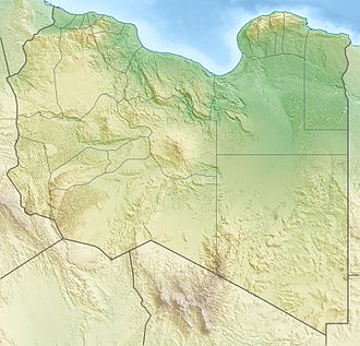
Gharyan volcanic field is a volcanic field in northwestern Libya, with the towns of Bani Walid, Gharyan, Mizdah and Tarhunah close by. [2]

Gharyan is one among several intraplate volcanic fields in Africa, which include Haruj, Hoggar, Jebel Marra and Tibesti. They are linked either with crustal domes or rifts and appear to be the consequence of lithosphere-mantle processes such as mantle plumes. [3] Haruj and Wau en Namus in Libya may be still active. [4]

The field has covered an area of about 3,000 square kilometres (1,200 sq mi) with lava domes, lava flows and volcanic cones [1] such as the shield volcanoes Ras el-Mohor and Ras Tebra. Exposed laccoliths are also common in some parts of the field, such as Kaf El Khalef, Kaf El Tekut, Kaf Mantrus, Kaf el-Tuam and Ras Tuint-Rabib. [5] The location of these vents appears to be controlled by a neighbouring graben and tectonic fractures. [4] The volcanic field developed on a basement formed by Mesozoic limestones. [2]

The field has erupted basanite and phonolite with a total volume of about 350 cubic kilometres (84 cu mi), [1] additional volcanic rocks are basaltic andesite, hawaiite and tephrite. [4] Basaltic rocks range from alkali basalt to tholeiite. [6]

Potassium-argon dating has yielded an age of about 12 to 1 million years ago for the field; [1] activity commenced in the Eocene with the basaltic plateau and continued in the late Eocene and later with lava domes and individual volcanoes. [6] Volcanic activity has been subdivided in several separate cycles. [7]
Related Research Articles

Payún Matrú Volcano in Argentina

Payún Matrú is a shield volcano in the Reserva Provincial La Payunia of the Malargüe Department, south of the Mendoza Province in Argentina. It lies in the back-arc region of the Andean Volcanic Belt, and was formed by the subduction of the Nazca Plate beneath the South American Plate. Payún Matrú, along with the Llancanelo, Nevado and Salado Basin volcanic fields, form the Payenia province. It has been proposed as a World Heritage Site since 2011.

Komatiite An ultramafic mantle-derived volcanic rock

Komatiite is a type of ultramafic mantle-derived volcanic rock defined as having crystallised from a lava of at least 18 wt% MgO. Komatiites have low silicon, potassium and aluminium, and high to extremely high magnesium content. Komatiite was named for its type locality along the Komati River in South Africa, and frequently displays spinifex texture composed of large dendritic plates of olivine and pyroxene.

Bazman

Bazman is a dormant stratovolcano in a remote desert region of Sistan and Baluchestan Province in south-eastern Iran. A 500-m-wide crater caps the summit of the dominantly andesitic-dacitic volcano, the flanks of which are covered by monogenetic centres especially to the northwest. Bazman is a geologically young volcano which formed mainly in the Quaternary, with the oldest dated rocks being 11.7 million years old and the youngest 0.6 million years. Although no historic eruptions have been reported from Bazman, it does contain fumaroles. Thus Bazman may be regarded as dormant, rather than extinct. Its satellite cones have been the source of basaltic lava flows.

Nevado de Longaví

Nevado de Longaví is a volcano in the Andes of central Chile. The 3,242 m (10,636 ft) high volcano lies in the Linares Province, which is part of the Maule Region. It features a summit crater and several parasitic vents. The volcano is constructed principally from lava flows. Two collapses of the edifice have carved collapse scars into the volcano, one on the eastern slope known as Lomas Limpias and another on the southwestern slope known as Los Bueye. The volcano features a glacier and the Achibueno and Blanco rivers originate on the mountain.

Ollagüe

Ollagüe or Ullawi is a massive andesite stratovolcano in the Andes on the border between Bolivia and Chile, within the Antofagasta Region of Chile and the Potosi Department of Bolivia. Part of the Central Volcanic Zone of the Andes, its highest summit is 5,868 metres (19,252 ft) above sea level and features a summit crater that opens to the south. The western rim of the summit crater is formed by a compound of lava domes, the youngest of which features a vigorous fumarole that is visible from afar.

Haruj Libyan mountain range

Haruj is a large volcanic field spread across 42,000–45,000 km2 (16,000–17,000 sq mi) in central Libya. It is one of several volcanic fields in Libya along with Tibesti, and its origin has been attributed to the effects of geologic lineaments in the crust.

Harrat al-Sham

The Ḥarrat al-Shām, also known as the Black Desert, is a region of rocky, basaltic desert straddling southern Syria and the northern Arabian Peninsula. It covers an area of some 40,000 km2 (15,000 sq mi) in the modern-day Syrian Arab Republic, Jordan, Israel and Saudi Arabia. Vegetation is characteristically open acacia shrubland with patches of juniper at higher altitudes

Kunlun Volcanic Group

Kunlun Volcanic Group, also known as Ashikule, is a volcanic field in northwestern Tibet. Eight other volcanic fields are also in the area. The field is within a basin that also contains three lakes.

Fueguino is a volcanic field in Chile. The southernmost volcano in the Andes, it lies on Tierra del Fuego's Cook Island and also extends over nearby Londonderry Island. The field is formed by lava domes, pyroclastic cones, and a crater lake.

Pali-Aike volcanic field

Pali-Aike volcanic field is a volcanic field in Argentina which straddles the border with Chile. It is part of a province of back-arc volcanoes in Patagonia, which formed from processes involving the collision of the Chile Rise with the Peru–Chile Trench. It lies farther east than the Austral Volcanic Zone, the volcanic arc which forms the Andean Volcanic Belt at this latitude.

Yanaurcu is a volcano in Ecuador. It consists of two Pleistocene lava domes reaching a maximum elevation of 4,535 metres (14,879 ft) and are of andesitic composition and older Pliocene volcanics.

Cerro de los Chenques

Cerro de los Chenques is a monogenetic volcano in the Chubut Province, Argentina, which is considered to be of Holocene age. The volcano developed on a basement formed by Mesoproterozoic and Neoproterozoic rocks and more recent volcanic and granitic formations.

Cima volcanic field Volcanic field in San Bernardino County, California

Cima volcanic field is a volcanic field in San Bernardino County, California, close to the border with Nevada. The volcanic field covers a surface area of 600 square kilometres (230 sq mi) within the Mojave National Preserve west of the Cima Dome and consists of about 40 volcanic cones with about 60 lava flows. The volcanic cones range from simple cones over multi-cratered mountains to eroded hills, and lava flows are up to 9.1 kilometres (5.7 mi) long. At least one lava tube exists in the field and can be visited.

Noronha hotspot

Noronha hotspot is a hypothesized hotspot in the Atlantic Ocean. It has been proposed as the candidate source for volcanism in the Fernando de Noronha archipelago of Brazil, as well as of other volcanoes also in Brazil and even the Bahamas and the Central Atlantic Magmatic Province.

Meidob volcanic field

Meidob volcanic field is a Holocene volcanic field in Darfur, Sudan. It is one of several volcanic fields in Africa whose origin is explained by the activity of mantle plumes and their interaction with crustal structures. Meidob lies at the southern margin of the Sahara.

Atakor volcanic field

Atakor volcanic field is a volcanic field in Algeria. It lies in the Hoggar mountains and consists of a variety of volcanic features such as lava flows and about 450 individual vents which create a spectacular scenery.

Bayuda volcanic field

Bayuda volcanic field is a volcanic field in Sudan, within the Bayuda Desert. It covers a surface of about 11 by 48 kilometres and consists of a number of cinder cones as well as some maars and explosion craters. These vents have erupted aa lava flows.

Honolulu Volcanics Volcanic field in Oʻahu, Hawaiʻi

The Honolulu Volcanics are a group of volcanoes which form a volcanic field on the island of Oʻahu, Hawaiʻi, more specifically in that island's southeastern sector and in the city of Honolulu from Pearl Harbor to the Mokapu Peninsula. It is part of the rejuvenated stage of Hawaiian volcanic activity, which occurred after the main stage of volcanic activity that on Oʻahu built the Koʻolau volcano. These volcanoes formed through dominantly explosive eruptions and gave rise to cinder cones, lava flows, tuff cones and volcanic islands. Among these are well known landmarks such as Diamond Head and Punchbowl Crater.

South Arch volcanic field Underwater volcanic field south of Hawaiʻi Island

South Arch volcanic field is an underwater volcanic field south of Hawaiʻi Island. It was active during the last 10,000 years, and covers an area of 35 by 50 kilometres at a depth of 4,950 metres (16,240 ft).

North Arch volcanic field

North Arch volcanic field is an underwater volcanic field north of Oahu, Hawaii. It covers an area of about 25,000 square kilometres (9,700 sq mi) and consists of large expanses of alkali basalt, basanite and nephelinite that form extensive lava flows and volcanic cones. Some lava flows are longer than 100 kilometres (62 mi).

References

  1. 1 2 3 4 5 "Gharyan Volcanic Field". Global Volcanism Program . Smithsonian Institution.
  2. 1 2 Al-Hafdh & Gafeer 2015, p. 71.
  3. Beccaluva et al. 2008, p. 253.
  4. 1 2 3 Lustrino et al. 2012, p. 218.
  5. Lustrino et al. 2012, p. 219.
  6. 1 2 Beccaluva et al. 2008, p. 254.
  7. Al-Hafdh & Gafeer 2015, p. 72.

Sources