
Odisha, formerly Orissa, is a state located in Eastern India. It is the eighth-largest state by area, and the eleventh-largest by population, with over 41 million inhabitants. The state also has the third-largest population of Scheduled Tribes in India. It neighbours the states of Jharkhand and West Bengal to the north, Chhattisgarh to the west, and Andhra Pradesh to the south. Odisha has a coastline of 485 kilometres (301 mi) along the Bay of Bengal in the Indian Ocean. The region is also known as Utkaḷa and is mentioned by this name in India's national anthem, Jana Gana Mana. The language of Odisha is Odia, which is one of the Classical languages of India.

Bargarh is one of the major towns of Western Odisha and a municipality in Bargarh district in the state of Odisha in India. It is the administrative headquarters of Bargarh District and an important town of Odisha because it is known as the "rice bowl of Odisha" due to its intense rice production, it is an agro-industrial hub and is also known as "city of handloom" because sambalpuri sari originated from here."Dhanu jatra" of Bargarh is world famous and is known as the "world's largest open air theatre". Bargarh was awarded with the "fastest moving city" award under the 50k-100k category in Swachh Sarbekhyan 2022 in the east zone.
Berhampur is a city on the eastern coastline of Odisha, India.
Sambalpur District is a district in the western part of state of Odisha, India. The historic city of Sambalpur is the district headquarters.

Burla is a town in Sambalpur city in the state of Odisha, India. It earlier had a Notified Area Council (NAC) until 2014 after which it was included in Sambalpur city under Sambalpur Municipal Corporation (SMC). It was earlier a small town on the banks of the Mahanadi. One can reach this place by road with National Highway 6 which is one of the busiest trunk routes in India as it connects Hazira to Kolkata. Hirakud Railway Station is at one end of the town and a walking distance from the Mahanadi Coal Limited (MCL).

Raigarh is a city in northern Chhattisgarh known as the 'Cultural capital of Chhattisgarh'; Raigarh is famous for its dance form “SUWA” and classical music; Raigarh is also known as Sanskritidhani.
Bargarh District is an administrative district of Odisha state in eastern India. The city of Bargarh is its district headquarters. The district was carved out of the erstwhile district of Sambalpur on 1 April 1993.

Balangir also known as Bolangir, is a town and a municipality, the headquarters of Balangir district in the state of Odisha, India. Balangir's cultural heritage makes it one of the finest places for tourists in Odisha. Balangir municipality is divided into twenty-one wards. It is spread over an area of 12,200 acres (4,900 ha).
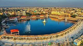
Sambalpur is the fifth largest city in the Indian State of Odisha. It is located on the banks of river Mahanadi, with a population of 335,761. Prehistoric settlements have been recorded there. It is the home of the Sambalpuri sari.

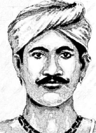
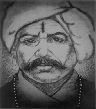
Bira Surendra Sai was a native Indian as well as a regional freedom fighter from what is now Odisha. He fought against the British rule in India after they dethroned the rulers of the Sambalpur State as he was the legal heir.

Sambalpuri is an Indo-Aryan language variety spoken in western Odisha, India. It is alternatively known as Western Odia, and as Kosali, a recently popularised but controversial term, which draws on an association with the historical region of Dakshina Kosala, whose territories also included the present-day Sambalpur region.
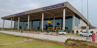
Veer Surendra Sai Airport, also known as Jharsuguda Airport, is a domestic airport serving Jharsuguda, Odisha, India. The airport is located 5 kilometres (3.1 mi) north-east from the city centre. The airport is located in Durlaga village, approximately 8.5 km (5.3 mi) from Jharsuguda Junction Railway Station. The airport is named after the revolutionary Veer Surendra Sai and it is the second commercial airport in the state of Odisha. The airport caters to areas like the districts of Jharsuguda, Sambalpur, Sundergarh, Bargarh, Debagarh, Bolangir, Subarnapur, Boudh of Orissa and Raigarh, Korba, Surguja, Jashpur districts of Chhattisgarh.
Sambalpur is a district of Odisha. Sambalpur city is the headquarter of Sambalpur district. It is named after the presiding Sambhal to Sambalpur. Sambalpur is an ancient settlement which at its earliest was a part of Dakshin Kosala. It was thus decided that it was established around 5000 BC around the time of Ramayana as Sambalpur was the dwelling place of the Sabara tribes and the Hirakud was the only source of diamond in ancient times. From its establishment to its dissolution into the British Empire, it was known as the Hirakhand Kingdom probably due to its diamond mines. Sambalpur is the cultural capital of Western Odisha.
Bhatli (Koshali) is a Vidhan Sabha constituency of Bargarh district, Odisha, India.

Sarangarh was a princely state in India during the British Raj ruled by a Raj Gond dynasty. The emblem of the state was a turtle.

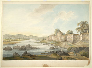
Sambalpur State, also known as Hirakhand Kingdom, was a kingdom founded in 1570. It ruled over Western Odisha and Eastern Chhattisgarh in central-eastern India prior to the Maratha occupation in 1800 AD. From 1849 AD, it was integrated with British Raj as a British District. Its capital was present-day Sambalpur city in Western Odisha.
Madhab Singh Bariha or Madho Singh was the Binjhal Zamindar (landlord) of Ghess locality of Bargarh district in Odisha and was a close associate of Veer Surendra Sai in the Sambalpur uprising against the British East India Company. He was hanged to death at the age of 72 on 31 December 1858 at Jail Chowk of Sambalpur, after being caught in the same year for his ferocious and heroic resistance to the British takeover of the region with their appalling policies. Three out of his four valiant sons were martyred while the eldest was sentenced to life imprisonment. His granddaughter Purnima committed suicide after the British hanged her rebellious husband from the Sonakhan Zamindari at Raipur.
Karunkar Singh Naik, commonly known as Karunakar Singh, was an Indian chieftain and rebel leader. He was the Gond Zamindar of Kolabira in what is today the Jharsuguda district of Odisha.
Kamal Singh Dao or only known as Kamal Singh was the son of Balabhadra Singh Dao, the Gond Zamindar (landlord) of Lakhanpur locality of Bargarh district of Odisha and was a major aide of Veer Surendra Sai during the Sambalpur uprising against the British. He along with his brothers Khageswar Singh and Neelambar Singh played an important role as one of the second in commands of Surendra Sai. Kamal's father Balabhadra Singh attained martyrdom in the earlier days of the rebellion. Kamal was treacherously killed in sleep while resting under a tree and when he was still in command of the rebels even though Surendra Sai himself had surrendered to the British. His brother Khageswar died under British imprisonment in Asirgarh jail.

Hirlipali is a village in Attabira Tehsil of Bargarh district of Odisha, India. The village is located on the banks of canal that flows reservoir water from Hirakud Dam. It is about 10 km from Attabira and about 20 km from Bargarh town. The total geographical area of Hirlipali Gram Panchayat is 25.19 square kilometers, and has a total population of 8,320 peoples. There are about 1,817 households in Hirlipali Gram Panchayat

