
Khordha district is an administrative division of the state of Odisha, India. It was formed on April 1, 1993, by the division of former Puri District into Puri, Khordha and Nayagarh districts. In the year 2000 the district name was changed to Khordha. The district headquarters is Khordha Town. The capital city of Bhubaneswar is located in this district. Khordha is the most urbanized of all the districts of Odisha.

Kendrapara District is an administrative district of Odisha state in eastern India. The town of Kendrapara is the district headquarters. Kendrapara District is situated in the eastern portion of the state, and is bounded on the north by Bhadrak district, on the east by the Bay of Bengal, on the south by Jagatsinghpur District, on the west by Cuttack District on the northwest by Jajpur District.

Gajapati district is a district of Odisha State in India. It was created from Ganjam District on 2 October, 1992. As of 2011 it is the third least populous district of Odisha, after Debagarh and Boudh. Gajapati district was named after Krushna Chandra Gajapati Narayan Deb, the King of the Paralakhemundi estate and the first Prime Minister of Orissa, who is remembered for his contribution in the formation of a separate state, and inclusion of his estate in Odisha. The district headquarters at Paralakhemundi, formerly a Zamindari, has been clustered within a radius of approximately 5 kilometers around the geometric centre of Paralakhemundi.

Jharsuguda is a district in Odisha, India with Jharsuguda town as its headquarters. This region is rich in coal and other mineral reserves. Of late, many small and medium scale iron and steel units have been set up in the vicinity of Jharsuguda town, giving impetus to the industrial growth of the district.

Sundargarh District is a district in the northwestern part of Odisha state in eastern India.

Subarnapur District, also called Sonepur District or Sonapur District, is an administrative district in Odisha state in eastern India. The town of Sonepur is the district headquarters. Sonepur is known as the Mandiramalini town of Odisha with more than hundred temples. The people of the Sonepur region are referred to as Sonepuria. From ancient times, Sonepur is considered as a holy city.

Puri district is a coastal district of the Odisha state of India. It has one sub-division, 11 tahasils and 11 blocks and comprises 1722 revenue villages. Puri is the only municipality of the district. Konark, Pipili, Satyabadi, Gop, Kakatpur and Nimapada are the NACs in this district while Brahmagiri being a semi-urban town.

Jajpur is a district of Odisha state in eastern India. The Odisha Government carried out a re-organisation of districts of Odisha in 1993. The erstwhile Cuttack district was split into multiple districts with Jajpur being one of them. The district came into being on 1 April 1993.
Balasore District, also known as Baleswar District, is an administrative district of Odisha state, in eastern India. Balasore is one of the coastal districts of Odisha and lies on the northernmost part of the state.

Angul is a town and a municipality and the headquarters of Angul district in the state of Odisha, India. Angul has an average elevation of 195 m (640 ft) above sea level. The total geographical area of the district is 6232 km2. From the point of view of area, it stands 11th among the 30 Districts of Odisha.
Chhatrapur (ଛତ୍ରପୁର) is a town and a Municipality in Ganjam district in the state of Odisha, India.
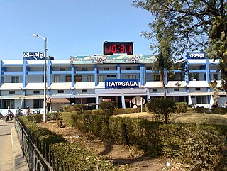
Rayagada is a municipality in Rayagada district in the Indian state of Odisha. It is the administrative headquarters of Rayagada district.
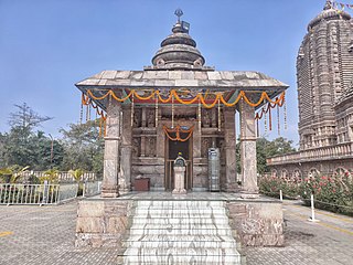
Khordha is a town and a municipality area in Khordha district in the Indian state of Odisha. Bhubaneswar, is the capital of Odisha located within the Khordha district and is only 25 km from Khordha town. Odisha State Highway 1 and National Highway 16 runs via this town.
Hinjilicut (Hinjilikatu) is a town and municipality of Ganjam district in the Indian state of Odisha.
Jaleswar is a town located in the Balasore district of Odisha, in India. It consists of 144 villages, with four major areas: Bada Bazar, Nua Bazar, Station Bazar, and Purana Bazar. Jaleswar is considered one of the new municipalities in the state, and Jaleswar forms a state assembly constituency along with Balipal Block.
Kabisuryanagar is a town and a NAC in Ganjam district in the Indian state of Odisha.

Khallikote is a town and a Notified Area Council in Ganjam district in the Indian state of Odisha.
Kodala is a town and a Notified Area Council in Ganjam District in the Indian State of Odisha.

Kendujhar District, is an administrative district of Odisha. The district is one of the fifth Scheduled Areas of Odisha. The town of Kendujhar is the district headquarters. The district has three sub-divisions, Anandapur, Champua, and Kendujhar.

