Gilberton, South Australia

Last updated

Gilberton
Adelaide,  South Australia
Population1,441 (2016 census) [1]
Established1840s [2]
Postcode(s) 5081
Location2 km (1 mi) from Adelaide GPO
LGA(s) Town of Walkerville
State electorate(s) Adelaide
Federal division(s) Adelaide
Suburbs around Gilberton:
Medindie Gardens Collinswood Walkerville
Medindie Gilberton St Peters
North Adelaide Hackney College Park

Gilberton (formerly Gilbert Town) is an inner northern suburb of Adelaide, South Australia on the northern bank of the River Torrens. It is a short distance from Adelaide's city centre. It is bounded by the river, Park Terrace, Stephen Terrace and Northcote Terrace. The suburb is largely residential with some large and ornate Victorian homes and approximately 2 kilometres (1 mi) of the Torrens Linear Park represent its southern boundary. The large homes in the suburb's northern section give it a historic character that is protected by government planning regulations. [3]

Contents

The area of Gilberton was first purchased in 1839 by a Richard Blundell as "Section 475" of the survey of Adelaide. Blundell, who lived in England, was declared bankrupt later that year. The section was subsequently sold by his creditors. Joseph Gilbert of Pewsey Vale winery fame, purchased the 134 acres (54.2 ha) section for £600/5s in 1846, naming it "Gilbert Town" and in 1852 dividing into 43 lots for sale or lease. Early activities in the area included a brickworks, farms and gardens and an abattoir. By 1847, the southern part of the town was planned, the plan completed by 1871 and extensive housing completed by the 1890s. [4]

The suburb is largely flat from the river north to Walkerville Terrace, then slopes upwards to its northern extent. Due to the elevation of views from the northern section, this land attracted wealthier purchasers. Some of their ornate Victorian homes, situated on large grounds, remain there today. At a large bend in the river, the location of today's St Peters River Park, gravel extraction, sand washing and landfill have all been commercial activities. Sand washing was replaced by a dump in 1961, leading to complaints from the neighbouring suburb of St Peters about fumes from the burning rubbish. After the land was purchased by St Peters, the bend was straightened and the dump reclaimed. [4]

Gilberton Bathing Reserve

Spectators on river bank, Australian championships February 1923 Gilberton Swimming Club 1923.jpg
Spectators on river bank, Australian championships February 1923

A section of the River Torrens, retained by weirs, was the home of the Gilberton Swimming Club, founded 1915, [5] and where many local children learned to swim. Arguably the most notable event to be held here was the Australian Swimming Championships, held between 17 and 24 February 1923, when many thousands of spectators lined the western bank. [6] The area was still in use for informal swimming in the 1950s then closed due to the presence of the bacteria E coli. Many relics of the Swimming Club era remain, including the fine Memorial Arch, which was erected in 1936 [7] to honour the contribution to the Club of Percy Frank Jervis (1870 – 13 January 1947). [8]

The nearby pedestrian suspension "swing" bridge linking Severn Street, Gilberton with Swing Bridge Lane, St Peters, was erected by Charles Francis Muller for Frank Woolley (1861-1941), a large landholder, in 1920. In 2017, it was rebuilt to modern safety standards as a joint project of the Town of Walkerville and the City of Norwood Payneham & St Peters, and opened in February 2018. It is in regular use by locals and is of interest to visitors. The original anchoring structures, which are of historic and architectural interest, have been preserved. The Torrens Linear Park runs nearby.

See also

Related Research Articles

Marion, South Australia Suburb of Adelaide, South Australia

Marion is a suburb in the City of Marion, around 10 kilometres (6.2 mi) south-west of the city centre of Adelaide, the capital of South Australia. Founded as a rural village in 1838 on the banks of the Sturt River, Marion was found to have rich soil and the population expanded rapidly. Colonel William Light laid out the plan for the village, as he had done with the City of Adelaide itself.

Norwood, South Australia Suburb of Adelaide, South Australia

Norwood is a suburb of Adelaide, about 4 km (2.5 mi) east of the Adelaide city centre. The suburb is in the City of Norwood Payneham & St Peters, whose predecessor was the oldest South Australian local government municipality.

South Road - and its southern section as Main South Road outside of Adelaide - is a major north–south conduit connecting Adelaide and the Fleurieu Peninsula, in South Australia. It is one of Adelaide's most important arterial and bypass roads. As South Road, it is designated part of route A2 within suburban Adelaide, and as Main South Road, it is designated part of routes A13 and B23.

Hackney, South Australia Suburb of Adelaide, South Australia

Hackney is an inner-eastern suburb of Adelaide, South Australia, in the City of Norwood Payneham St Peters. It is adjacent to the Adelaide Park Lands, the Adelaide city centre and North Adelaide. The O-Bahn Busway passes along Hackney Road, part of the City Ring Route, Adelaide, which forms its western boundary. Its other boundaries are the River Torrens (north), the continuation of North Terrace through Kent Town (south), and a series of small streets and lanes to the east.

Kent Town is an inner suburb of Adelaide, South Australia. It is located in the City of Norwood Payneham & St Peters.

Marden is a suburb of Adelaide, South Australia in the City of Norwood Payneham St Peters. The suburb is bordered by the River Torrens to the north, O.G. Rd to the east, Payneham Rd to the south and Battams Rd to the west.

Thebarton, South Australia Suburb of Adelaide, South Australia

Thebarton, formerly Theberton, on Kaurna land, is an inner-western suburb of Adelaide, South Australia in the City of West Torrens. The suburb is bounded by the River Torrens to the north, Port Road and Bonython Park to the east, Kintore Street to the south, and South Road to the west.

Town of Walkerville Local government area in South Australia

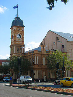
The Corporation of the Town of Walkerville is a small local government area in the central suburbs of Adelaide, South Australia.

Anzac Highway Highway in Adelaide

Anzac Highway is an 8.7-kilometre-long (5.4 mi) main arterial road heading southwest from the city of Adelaide, the capital of South Australia, to the beachside suburb of Glenelg.

Hope Valley, South Australia Suburb of Adelaide, South Australia

Hope Valley is a suburb of Adelaide in the City of Tea Tree Gully.

Walkerville, South Australia Suburb of Adelaide, South Australia

Walkerville is a suburb of Adelaide, South Australia. It lies just north east of the city centre, about 4 kilometres (2.5 mi) from the Adelaide GPO. Walkerville is one of South Australia's most affluent suburbs and in 2012 it was South Australia's second "top earning suburb."

Adelaide city centre Suburb of Adelaide, South Australia

Adelaide city centre is the inner city locality of Greater Adelaide, the capital city of South Australia. It is known by locals simply as "the City" or "Town" to distinguish it from Greater Adelaide and from the City of Adelaide local government area. The population was 15,115 in the 2016 census.

Kilkenny, South Australia Suburb of Adelaide, South Australia

Kilkenny is an inner north-western suburb of Adelaide, South Australia. It is located in the City of Charles Sturt. It is named after Kilkenny, Ireland.

Rachel Sanderson Australian politician

Rachel Sanderson is an Australian politician who represented the seat of Adelaide in the South Australian House of Assembly for the South Australian Division of the Liberal Party of Australia from the 2010 election to the 2022 election. Sanderson served as the minister for Child Protection in the Marshall Ministry.

Park 12

Park 12, is one of the 29 Parks that make up the Adelaide Park Lands. It consists of 55.5 hectares bounded by North Terrace, Frome Road, Sir Edwin Smith Avenue and King William Road

The District Council of Yatala was a local government area of South Australia established in 1853 and abolished in 1868.

Hindmarsh was an electoral district of the House of Assembly in the Australian state of South Australia from 1938 to 1970. It was in the northwestern suburbs of Adelaide.

The District Council of East Torrens was a local government council of South Australia from 1853 to 1997.

The Corporate Town of St Peters was a local government area in South Australia from 1883 to 1997.

References

  1. Australian Bureau of Statistics (27 June 2017). "Gilberton (State Suburb)". 2016 Census QuickStats. Retrieved 24 July 2019. OOjs UI icon edit-ltr-progressive.svg
  2. Lewis J (1988,p.33-34) shows a plan for the southern section of the suburb dated 1847 and a complete 1871 town plan but does not note an establishment date.
  3. "Development Act 1993, Walkerville (CT)" (PDF). 15 February 2007. p. 54. Archived from the original (PDF) on 30 August 2007. Retrieved 10 September 2007.
  4. 1 2 Lewis, John (1988). The Walkerville Story, 150 years. Walkerville, South Australia: The corporation of the town of Walkerville. pp. 32–35. ISBN   0-7316-3067-X.
  5. "Swimming". The Register (Adelaide) . Vol. LXXX, no. 21, 305. South Australia. 22 February 1915. p. 9. Retrieved 2 March 2018 via National Library of Australia.
  6. "Swimming". The Register (Adelaide) . Vol. LXXXVIII, no. 25, 636. South Australia. 26 February 1923. p. 5. Retrieved 2 March 2018 via National Library of Australia.
  7. "Carnival at Gilberton Today". The Advertiser (Adelaide) . South Australia. 7 March 1936. p. 20. Retrieved 2 March 2018 via National Library of Australia.
  8. "Death Of Mr. Percy Jervis". The Advertiser (Adelaide) . South Australia. 14 January 1947. p. 6. Retrieved 2 March 2018 via National Library of Australia.

Coordinates: 34°54′00″S138°36′43″E / 34.9°S 138.612°E / -34.9; 138.612