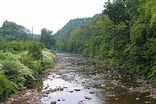
Muncy Creek is a tributary of the West Branch Susquehanna River in Sullivan County and Lycoming County, at Pennsylvania, in the United States. It is approximately 34.5 miles (55.5 km) long. The watershed of the creek has an area of 216 square miles (560 km2). The creek's discharge averages 49 cubic feet per second (1.4 m3/s) at Sonestown, but can be up to a thousand times higher at Muncy. The headwaters of the creek are on the Allegheny Plateau. Rock formations in the watershed include the Chemung Formation and the Catskill Formation.

Chillisquaque Creek is a tributary of the West Branch Susquehanna River in Montour County and Northumberland County, in Pennsylvania, in the United States. It is approximately 20.2 miles (32.5 km) long and flows through Derry Township, Washingtonville, and Liberty Township in Montour County and East Chillisquaque Township and West Chillisquaque Township in Northumberland County. The watershed of the creek has an area of 112 square miles (290 km2). Agricultural impacts have caused most of the streams in the watershed of the creek to be impaired. Causes of impairment include sedimentation/siltation and habitat alteration. The average annual discharge of the creek between 1980 and 2014 ranged from 48.2 to 146.0 cubic feet per second. Its watershed mainly consists of rolling agricultural land. The creek's channel flows through rock formations consisting of sandstone and shale. It is a warmwater stream.

Logan Run is a tributary of the Susquehanna River in Northumberland County, Pennsylvania, in the United States. It is approximately 5.7 miles (9.2 km) long and flows through Rush Township. The watershed of the stream has an area of 8.70 square miles (22.5 km2) and is in the Lower Susquehanna River drainage basin. The stream is crossed by five bridges and was home to a gristmill and sawmill at some point in the past. It is considered to be a coldwater fishery and a migratory fishery. Rock of the Catskill Formation, the Pocono Formation, and the Hamilton Formation are present in the watershed.

Hunlock Creek is a tributary of the Susquehanna River in Luzerne County, Pennsylvania, in the United States. It is approximately 7.8 miles (12.6 km) long and flows through Lehman Township and Hunlock Township. The watershed of the creek has an area of 32.5 square miles (84 km2) and is situated in northwestern Luzerne County. It has one named tributary, which is known as Roaring Brook, and a number of unnamed and unofficially named tributaries, such as "West Branch Hunlock Creek".
Fall Brook is a tributary of the Lackawanna River in Susquehanna County and Lackawanna County, Pennsylvania, in the United States. It is approximately 7.9 miles (12.7 km) long and flows through Clifford Township in Susquehanna County and Fell Township, Carbondale Township, and Carbondale in Lackawanna County. The watershed of the stream has an area of 12.4 square miles (32 km2), making it one of the largest tributaries of the Lackwanna River. It is not designated as impaired, but does experience flow loss. The stream begins on the Allegheny Plateau and passes through the Fall Brook Gap. It also flows over the Fall Brook Falls, which are 60 feet (18 m) high. Fall Brook is situated within the Coal Region.
McKee Run is a tributary of County Line Branch in Montour County, Pennsylvania, in the United States. It is approximately 4.1 miles (6.6 km) long and flows through Anthony Township. The watershed of the stream has an area of 2.68 square miles (6.9 km2). The stream is designated as impaired by siltation and removal of vegetation due to agriculture. Land uses in the watershed include forested land, croplands, and pastures. A number of bridges cross the stream.

Boile Run is a tributary of the Susquehanna River in Northumberland County, Pennsylvania, in the United States. It is approximately 4.7 miles (7.6 km) long and flows through Lower Augusta Township. The watershed of the stream has an area of 5.97 square miles (15.5 km2). The stream is not designated as an impaired waterbody and is a relatively small stream. There was a mill on Boile Run in the second half of the 1800s and several bridges have been built over the stream. Its watershed is designated as a Warmwater Fishery and a Migratory Fishery.

Dry Run is a tributary of the West Branch Susquehanna River in Northumberland County, Pennsylvania, in the United States. It is approximately 4.1 miles (6.6 km) long and flows through Delaware Township. The watershed of the stream has an area of 3.98 square miles (10.3 km2). The stream is impaired by sedimentation/siltation from agriculture and is a relatively small valley stream. Several bridges have been constructed across it. The stream is designated as a Warmwater Fishery and a Migratory Fishery.

Spring Creek is a tributary of White Deer Hole Creek in Lycoming County and Union County, in Pennsylvania, in the United States. It is approximately 8.2 miles (13.2 km) long and flows through Washington Township in Lycoming County and Gregg Township in Union County. The watershed of the creek has an area of 21.1 square miles (55 km2). The creek is not designated as an impaired waterbody. The area in its vicinity was settled by 1787 and a mill was constructed on it in 1842. A number of bridges have been constructed over the creek. Its drainage basin is designated as a Trout Stocked Fishery and a Migratory Fishery.
Black Run is a tributary of the West Branch Susquehanna River in Lycoming County and Union County, in Pennsylvania, in the United States. It is approximately 3.6 miles (5.8 km) long and flows through Brady Township in Lycoming County and Gregg Township in Union County. The watershed of the stream has an area of 5.87 square miles (15.2 km2). The stream is not designated as an impaired waterbody. It is a relatively small stream with its mouth located near Montgomery. The stream's watershed is designated as a Warmwater Fishery and a Migratory Fishery.

Turkey Run is a tributary of the West Branch Susquehanna River in Lycoming County, Pennsylvania, in the United States. It is approximately 2.2 miles (3.5 km) long and flows through Clinton Township. The watershed of the stream has an area of 2.18 square miles (5.6 km2). The stream is not designated as an impaired waterbody. It is a relatively small stream and is located near State Correctional Institution – Muncy. The stream's watershed is designated as a Warmwater Fishery and a Migratory Fishery.

Shepman Run is a tributary of Little Muncy Creek in Lycoming County, Pennsylvania, in the United States. It is approximately 2.6 miles (4.2 km) long and flows through Moreland Township. The watershed of the stream has an area of 1.59 square miles (4.1 km2). A covered bridge crosses the stream. Shepman Run is classified as a Coldwater Fishery and a Migratory Fishery.

Beaver Run is a tributary of Little Muncy Creek in Sullivan County and Lycoming County, in Pennsylvania, in the United States. It is approximately 7.9 miles (12.7 km) long and flows through Davidson Township in Sullivan County and Penn Township and Franklin Township in Lycoming County. The watershed of the stream has an area of 12.7 square miles (33 km2). The stream is dammed by the Beaver Lake Dam and a number of bridges have been constructed across it. Beaver Run has one named tributary, which is known as Marsh Run.

Big Run is a tributary of Little Muncy Creek in Lycoming County, Pennsylvania, in the United States. It is approximately 4.3 miles (6.9 km) long and flows through Penn Township and Franklin Township. The watershed of the stream has an area of 3.99 square miles (10.3 km2). The stream is impaired by a high total concentration of nitrogen. A number of bridges have been constructed across it.

German Run is a tributary of Little Muncy Creek in Lycoming County, Pennsylvania, in the United States. It is approximately 4.9 miles (7.9 km) long and flows through Franklin Township and Moreland Township. The watershed of the stream has an area of 6.87 square miles (17.8 km2). Part of the stream and one of its unnamed tributaries are designated as impaired waterbodies, with the source of the impairment being agriculture. German Run is classified as a Coldwater Fishery and a Migratory Fishery. Natural gas operations have occurred in the general vicinity of the stream.

Broad Run is a tributary of Little Muncy Creek in Lycoming County, Pennsylvania, in the United States. It is approximately 3.7 miles (6.0 km) long and flows through Moreland Township. The watershed of the stream has an area of 2.94 square miles (7.6 km2). At least one bridge has been constructed over the stream, carrying State Route 2067. Broad Run is classified as a Coldwater Fishery.

Fidlers Run is a tributary of the Susquehanna River in Northumberland County, Pennsylvania, in the United States. It is approximately 3.1 miles (5.0 km) long and flows through Jackson Township and Lower Mahanoy Township. The watershed of the stream has an area of 6.88 square miles (17.8 km2). The stream is not designated as an impaired waterbody, although a reaches of a few of its unnamed tributaries are. It is a small stream, with a width of 3 to 5 feet. Large areas of agricultural land occur along a substantial portion of its length.

Dalmatia Creek is a tributary of the Susquehanna River in Northumberland County, Pennsylvania, in the United States. It is approximately 2.8 miles (4.5 km) long and flows through Lower Mahanoy Township. The watershed of the creek has an area of 2.80 square miles (7.3 km2). The creek has no named tributaries, but several unnamed ones. Both it and its tributaries are designated as impaired waterbodies due to sedimentation/siltation from crop-related agriculture and vegetation removal. Streambank erosion also occurs in the watershed. The creek is in the Ridge and Valley physiographic province.
Dundaff Creek is a tributary of East Branch Tunkhannock Creek in Susquehanna County and Lackawanna County, in Pennsylvania, in the United States. It is approximately 6.7 miles (10.8 km) long and flows through Clifford Township in Susquehanna County and Greenfield Township in Lackawanna County. The watershed of the creek has an area of 10.3 square miles (27 km2). The creek has no named tributaries and is not designated as an impaired waterbody.
Laurel Run is a tributary of Little Muncy Creek in Columbia County and Lycoming County, in Pennsylvania, in the United States. It is approximately 6.8 miles (10.9 km) long and flows through Madison Township and Pine Township in Columbia County and Franklin Township and Moreland Township in Lycoming County. The watershed of the stream has an area of 12.2 square miles (32 km2). It is classified as a Coldwater Fishery and a Migratory Fishery. A number of bridges have been constructed over the stream.


