
Glottenham Castle was a castle in Mountfield, East Sussex, around 5 miles (8 km) north of Battle Abbey. [1] Built in the 13th century, it was abandoned in the late 16th or 17th century.
Glottenham Castle was a castle in Mountfield, East Sussex, around 5 miles (8 km) north of Battle Abbey. [1] Built in the 13th century, it was abandoned in the late 16th or 17th century.
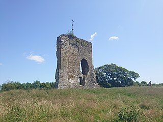
The Sussex manor of Glottenham has had boundary ditches since the 11th century, and the moat at Glottenham Castle is believed to date from around 1200. [2] Glottenham Castle was built in the late 13th century. The castle had stone walls, two square towers and a gatehouse. [3] [4] The castle was owned by the de Etchingham family, before being abandoned in the late 16th or 17th century. [2] In the 19th century, the land around Glottenham Castle was used for growing hops. [5] In 1920, the castle's estate was sold at auction, and was listed as 595 acres (241 ha). [6]
In 1990, the site was listed under the Ancient Monuments and Archaeological Areas Act 1979. [2] The site is now a popular camping and glamping site. [7] [8]

Battle Abbey is a partially ruined Benedictine abbey in Battle, East Sussex, England. The abbey was built on the site of the Battle of Hastings and dedicated to St Martin of Tours. It is a Scheduled Monument.

Neath Abbey was a Cistercian monastery, located near the present-day town of Neath in South Wales, UK. It was once the largest abbey in Wales. Substantial ruins can still be seen, and are in the care of Cadw. Tudor historian John Leland called Neath Abbey "the fairest abbey of all Wales."

A hillfort is a type of earthwork used as a fortified refuge or defended settlement, located to exploit a rise in elevation for defensive advantage. They are typically European and of the Bronze Age or Iron Age. Some were used in the post-Roman period. The fortification usually follows the contours of a hill and consists of one or more lines of earthworks, with stockades or defensive walls, and external ditches.

The River Rother flows for 35 miles (56 km) through the English counties of East Sussex and Kent. Its source is near Rotherfield in East Sussex, and its mouth is on Rye Bay, part of the English Channel. Prior to 1287, its mouth was further to the east at New Romney, but it changed its course after a great storm blocked its exit to the sea. It was known as the Limen until the sixteenth century. For the final 14 miles (23 km), the river bed is below the high tide level, and Scots Float sluice is used to control levels. It prevents salt water entering the river system at high tides, and retains water in the river during the summer months to ensure the health of the surrounding marsh habitat. Below the sluice, the river is tidal for 3.7 miles (6.0 km).

Glastonbury Abbey was a monastery in Glastonbury, Somerset, England. Its ruins, a grade I listed building and scheduled ancient monument, are open as a visitor attraction.

Lewes Castle is a medieval castle in the town of Lewes in East Sussex, England. Originally called Bray Castle, it occupies a commanding position guarding the gap in the South Downs cut by the River Ouse and occupied by the towns of Lewes and Cliffe. It stands on a man-made mount just to the north of the high street in Lewes, and is constructed from local limestone and flint blocks.

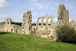
The Abbey of St Mary is a ruined Benedictine abbey in York, England and a scheduled monument.

Bodiam is a small village and civil parish in the Rother District of East Sussex, England. It lies in the valley of the River Rother, near to the villages of Sandhurst and Ewhurst Green.

Mountfield is a village and civil parish in the Rother district of East Sussex, England, and three miles (5 km) north-west of Battle. It is mentioned in the Domesday Book.
Buildings and structures in Sheffield have been constructed over a time-span ranging from the 13th century to the present day. The majority of Sheffield's older buildings were built during the Industrial Revolution, with many medieval buildings demolished in the 19th century; some older buildings were lost during the Sheffield Blitz. Sheffield can only lay claim to five Grade I listed buildings, two of which are in the city centre.
Cleeve Abbey is a medieval monastery located near the village of Washford, in Somerset, England. It is a Grade I listed building and has been scheduled as an ancient monument.
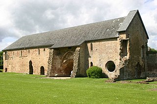
Bayham Old Abbey is an English Heritage property, located near Lamberhurst, Kent, England. Founded c. 1208 through a combination of the failing Premonstratensian monasteries of Otham and Brockley, Bayham functioned as an abbey until its dissolution in the 16th century. The ruins were partially modified in the late 18th century, to provide a better landscape feature during landscaping of the new Bayham Abbey mansion park, and were donated to the state in 1961.

Skipsea Castle was a Norman motte and bailey castle near the village of Skipsea, East Riding of Yorkshire, England. Built around 1086 by Drogo de la Beuvrière, apparently on the remains of an Iron Age mound, it was designed to secure the newly conquered region, defend against any potential Danish invasion and control the trade route across the region leading to the North Sea. The motte and the bailey were separated by Skipsea Mere, an artificial lake that was linked to the sea during the medieval period via a navigable channel. The village of Skipsea grew up beside the castle church, and the fortified town of Skipsea Brough was built alongside the castle around 1160 to capitalise on the potential trade.

Beverston Castle, also known as Beverstone Castle or Tetbury Castle, was constructed as a medieval stone fortress in the village of Beverston, Gloucestershire, England. The property is a mix of manor house, various small buildings, extensive gardens and the medieval ruins of the fortified building. The castle was founded in 1229 by Maurice de Gaunt.
The medieval Knepp Castle is to the west of the village of West Grinstead, West Sussex, England near the River Adur and the A24.
A shell keep is a style of medieval fortification, best described as a stone structure circling the top of a motte.

Iberg Castle is a ruined castle located on Iberg mountain in the municipality of Riniken in the canton of Aargau in Switzerland. Only a few remnants of the ruins are visible.
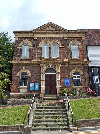
Robertsbridge United Reformed Church is a former United Reformed Church place of worship in Robertsbridge, a village in the district of Rother in the English county of East Sussex. Built for Congregational worshippers in 1881 following their secession from a long-established Wesleyan Methodist chapel, it was the third Nonconformist place of worship in the village, whose nearest parish church was in the neighbouring settlement of Salehurst. Like the former Strict Baptist and Methodist chapels in the village, which have both closed, it no longer serves Robertsbridge as a place of worship. Local architect Thomas Elworthy's distinctive design—a "rich" and highly decorated blend of several styles—has divided opinion amongst architectural historians. English Heritage has listed the church at Grade II for its architectural and historical importance.

There are over 670 scheduled monuments in the ceremonial county of Somerset in South West England. The county consists of a non-metropolitan county, administered by Somerset County Council, which is divided into five districts, and two unitary authorities. The districts of Somerset are West Somerset, South Somerset, Taunton Deane, Mendip and Sedgemoor. The two administratively independent unitary authorities, which were established on 1 April 1996 following the breakup of the county of Avon, are North Somerset and Bath and North East Somerset. These unitary authorities include areas that were once part of Somerset before the creation of Avon in 1974.
Sussex in the High Middle Ages includes the history of Sussex from the Norman Conquest in 1066 until the death of King John, considered by some to be the last of the Angevin kings of England, in 1216. It was during the Norman period that Sussex achieved its greatest importance in comparison with other English counties. Throughout the High Middle Ages, Sussex was on the main route between England and Normandy, and the lands of the Anglo-Norman nobility in what is now western France. The growth in Sussex's population, the importance of its ports and the increased colonisation of the Weald were all part of changes as significant to Sussex as those brought by the neolithic period, by the Romans and the Saxons. Sussex also experienced the most radical and thorough reorganisation of land in England, as the Normans divided the county into five tracts of lands called rapes. Although Sussex may have been divided into rapes earlier in its history, under the Normans they were clearly administrative and fiscal units. Before the Norman Conquest Sussex had the greatest concentration of lands belonging to the family of Earl Godwin. To protect against rebellion or invasion, the scattered Saxon estates in Sussex were consolidated into the rapes as part of William the Conqueror's 'Channel march'.