Related Research Articles
Thornfield is an unincorporated community in Ozark County, Missouri, United States. It is located 15 miles (24 km) northwest of Gainesville, on Route 95 at the Little North Fork of the White River on the edge of the Mark Twain National Forest between Wasola to the northeast and Longrun to the southwest. Hammond, the site of the historic Hammond Mill, lies on the Little North Fork 2.5 miles (4.0 km) southeast of Thornfield. Thornfield has a post office with ZIP code 65762.
Echo Lake Provincial Park is a provincial park in British Columbia, Canada, located south-east of Lumby in the Okanagan Highlands, to the south of BC Highway 6.
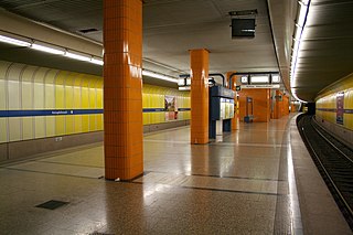
Holzapfelkreuth is an U-Bahn station in Munich on the U6.
Wattenburg or Wattenberg is an unincorporated community located in Weld County, Colorado, United States. The U.S. Post Office at Fort Lupton now serves Wattenburg postal addresses.
Calvertville is an unincorporated community in Highland Township, Greene County, Indiana, United States.
Bryant Township was a township in Logan County, North Dakota, United States. The former township was merged into the West Logan Unorganized Territory.

The Kettle River Range, often called the Kettle Range, is the southernmost range of the Monashee Mountains, located in far southeastern British Columbia, Canada and Ferry County, Washington, in the United States. Most of the northern half of the range is protected by the Colville National Forest and the southern half of the range is located on the Colville Indian Reservation. The highest peak is Copper Butte, which reaches 2,177 metres (7,142 ft). The range is crossed by Washington State Route 20 at Sherman Pass.
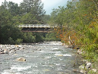
Slesse Creek is a tributary of the Chilliwack River in North America. It flows through Whatcom County in the U.S. state of Washington and through the Canadian province of British Columbia. The creek is known as Silesia Creek in the United States and as Slesse Creek in Canada.

Selma is an unincorporated community in Madison Township, Clark County, Ohio, USA.
Packerton is an unincorporated community in Clay Township, Kosciusko County, in the U.S. state of Indiana.
Cromanton is an unincorporated community in Bay County, in the U.S. state of Florida.
Covada is an unincorporated community in Ferry County, in the U.S. state of Washington.
Eureka is an unincorporated community in Walla Walla County, in the U.S. state of Washington.
Riparia is an extinct town in Whitman County, in the U.S. state of Washington. The GNIS classifies it as a populated place.
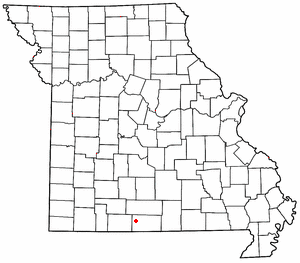
Arnica is an unincorporated community in Cedar County, in the U.S. state of Missouri.
Sampsel is an unincorporated community in Livingston County, in the U.S. state of Missouri.
Bacon is an unincorporated community in northeast Moniteau County, in the U.S. state of Missouri. The community is on Moniteau Creek approximately seven miles northeast of California.
Blue Ball is an unincorporated community in Scott and Yell counties, in the U.S. state of Arkansas.
References
- ↑ U.S. Geological Survey Geographic Names Information System: Godfrey (historical)
- ↑ "Post Offices". Jim Forte Postal History. Archived from the original on March 6, 2016. Retrieved August 1, 2016.
- ↑ Meany, Edmond S. (1923). Origin of Washington geographic names. Seattle: University of Washington Press. p. 98.
Municipalities and communities of Stevens County, Washington, United States | ||
|---|---|---|
| Cities |  | |
| Towns | ||
| CDPs | ||
| Other communities | ||
| Ghost towns | ||
48°42′31″N118°06′59″W / 48.70861°N 118.11639°W
| | This Stevens County, Washington state location article is a stub. You can help Wikipedia by expanding it. |