Hatchechubbee is an unincorporated community in Russell County, Alabama, United States. Hatchechubbee is located at the junction of Alabama State Route 26 and County Route 65, 6.5 miles (10.5 km) west-southwest of Seale. Hatchechubbee has a post office with ZIP code 36858, which opened on August 17, 1855. The community's name is derived from the Creek words hachi meaning "creek" and chaba meaning "halfway".
Goodspring is an unincorporated community in Giles County, Tennessee, United States. Its ZIP code is 38460.

Wing is an unincorporated community in Covington County, Alabama, United States.
Range is an unincorporated community in Conecuh County, Alabama, United States. Range is located along Alabama State Route 41, 6.7 miles (10.8 km) south of Repton. Range has a post office with ZIP code 36473.

Highland Home is an unincorporated community in Crenshaw County, Alabama, United States. Highland Home is located on U.S. Route 331, 16.6 miles (26.7 km) north of Luverne. Highland Home has a post office with ZIP code 36041, which opened on July 15, 1837. Located mostly on highway 331 that also runs to Luverne, Alabama.

Little River is an unincorporated community in Baldwin County, Alabama, United States. Its ZIP code is 36550.

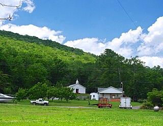
Estillfork is an unincorporated community in Jackson County, Alabama, United States. It is located in a rugged area at the head of the Paint Rock Valley in northern Jackson County. Just south of the community, the stream with which it shares its name, Estill Fork, joins Hurricane Creek to form the Paint Rock River. The Cumberland Plateau rises immediately to the east, and the Alabama-Tennessee state line passes a few miles to the north.

Hollytree is an unincorporated community in Jackson County, Alabama, United States. It is located on Alabama State Route 65, 9.7 miles (15.6 km) northeast of Gurley in the Paint Rock Valley. Hollytree has a post office with ZIP code 35751.
Princeton is an unincorporated community in Jackson County, Alabama, United States. Princeton is located on Alabama State Route 65 in the upper Paint Rock Valley. Skyline lies just over 7 miles (11 km) miles to the east atop the Cumberland Plateau, and the Alabama–Tennessee state line passes several miles to the north. Princeton has a post office with ZIP code 35766.
Trenton is an unincorporated community in Jackson County, Alabama, United States. It is located on Alabama State Route 65, 7.7 miles (12.4 km) east-northeast of Gurley in the Paint Rock Valley. Trenton had a post office until it closed on November 5, 2011; it still has its own ZIP code, 35774.
DeArmanville is an unincorporated community in Calhoun County, Alabama, United States, located on the southeast boundary of Anniston. DeArmanville has a post office with ZIP code 36257.
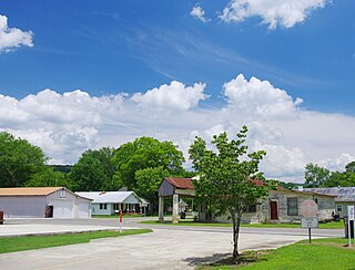
Duncanville is an unincorporated community in Tuscaloosa County, Alabama, United States. Duncanville is located along U.S. Route 82, 12.5 miles (20.1 km) southeast of Tuscaloosa. Duncanville has a post office with ZIP code 35456, which opened on August 22, 1898. Duncanville was named in honor of either William M. Duncan, a local property owner, or W. Butler Duncan, an official with the Gulf, Mobile, and Northern Railroad.
Echola is an unincorporated community in Tuscaloosa County, Alabama, United States. Echola is 15.8 miles (25.4 km) northwest of Tuscaloosa. Echola has a post office with ZIP code 35457. Echola was previously known as Elbert. Due to possible confusion with Elberta, Alabama, the postmaster, Golden Mayfield, created the name Echola by combining "echo" and "Alabama".
Fosters is an unincorporated community in Tuscaloosa County, Alabama, United States. Fosters is located along U.S. Route 11 and U.S. Route 43, 10.4 miles (16.7 km) southwest of Tuscaloosa. Fosters has a post office with ZIP code 35463. Fosters is named in honor of the family of James Foster, who settled in the area in 1818.
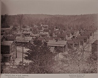
Kellerman is an unincorporated community in Tuscaloosa County, Alabama, United States, six miles (9.7 km) north of Brookwood. The community formed around a coal mining operation owned by the Central Iron & Coal Co. of New York. Kellerman was a company town, and the houses were owned by the company. When mining operations ceased in 1962, almost all of the nearly 5,000 residents eventually moved away leaving less than 10 houses remaining. The Kellerman post office with ZIP code 35468, which opened on August 6, 1902, is now located at the Alabama Mining Museum in Dora, Alabama Kellerman was most likely named for a civil engineer with the Kellerman Mine Company.
Samantha is an unincorporated community in Tuscaloosa County, Alabama, United States. Samantha is located along U.S. Route 43, 14.8 miles (23.8 km) north of Tuscaloosa. Samantha has a post office with ZIP code 35482. Samantha was named in honor of the wife of the first postmaster, Sylvester Monroe Cowden.
Alton is an unincorporated community in Jefferson County, Alabama, United States. Alton is located along Interstate 459, 10 miles (16 km) east-northeast of downtown Birmingham. Alton has a post office with ZIP code 35015. Part of the community has been annexed into the city of Birmingham, while the remainder remains an unincorporated area surrounded by the city.
Maylene is an unincorporated community in Shelby County, Alabama, United States. While the community was once unincorporated, it is now part of southern Alabaster. Maylene has a post office with ZIP code 35114. One site in Maylene, the Meredith-McLaughlin House, is listed on the Alabama Register of Landmarks and Heritage.
Palmerdale is an area in Jefferson County, Alabama, United States. Most of the community falls within the city limits of Pinson. Palmerdale is located on Alabama State Route 75, 4 miles (6.4 km) north-northeast of the downtown area of Pinson.
Sycamore is an unincorporated community in Talladega County, Alabama, United States, located near Alabama State Route 21, 6.1 miles (9.8 km) north-northeast of Sylacauga. Sycamore has a post office with ZIP code 35149. Sycamore was originally called Sycamore Grove, and was named for the sycamore trees which grew at the site. The post office was established in 1876.