Oakman, Alabama

Last updated

Oakman, Alabama
Entrance sign for Oakman - Alabama.jpg
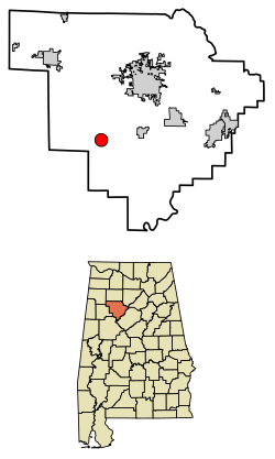
Walker County Alabama Incorporated and Unincorporated areas Oakman Highlighted 0155992.svg
Location of Oakman in Walker County, Alabama.
Coordinates: 33°42′49″N87°23′10″W / 33.71361°N 87.38611°W / 33.71361; -87.38611
Country United States
State Alabama
County Walker
Area
[1]
  Total3.09 sq mi (8.00 km2)
  Land3.08 sq mi (7.98 km2)
  Water0.01 sq mi (0.02 km2)
Elevation
341 ft (104 m)
Population
 (2020)
  Total771
  Density250.16/sq mi (96.60/km2)
Time zone UTC-6 (Central (CST))
  Summer (DST) UTC-5 (CDT)
ZIP code
35579
Area code(s) 205, 659
FIPS code 01-55992
GNIS feature ID0152754

Oakman is a town in Walker County, Alabama, United States. At the 2020 census the population was 771, down from 789 in 2010. Initially named Day (or Day's) Gap, it was renamed Oakman and incorporated in 1895. [2]

Contents

Geography

Oakman is located at 33°42′49″N87°23′10″W / 33.71361°N 87.38611°W / 33.71361; -87.38611 (33.713594, -87.386111). [3]

According to the U.S. Census Bureau, the town has a total area of 3.1 square miles (8.0 km2), all of it land. It is the only town in Alabama with perfectly round city limits.

Demographics

Historical population
CensusPop.Note
1890 421
1900 50319.5%
1910 1,065111.7%
1920 1,0831.7%
1930 927−14.4%
1940 897−3.2%
1950 1,02213.9%
1960 849−16.9%
1970 8530.5%
1980 770−9.7%
1990 8469.9%
2000 94411.6%
2010 789−16.4%
2020 771−2.3%
U.S. Decennial Census [4]
2013 Estimate [5]

Oakman first appeared on the 1890 census as the town of Day (or Day's) Gap. It changed its name in 1894 to Oakman and has remained since.

As of the census [6] of 2000, there were 944 people, 386 households, and 265 families residing in the town. The population density was 303.1 inhabitants per square mile (117.0/km2). There were 449 housing units at an average density of 144.1 per square mile (55.6/km2). The racial makeup of the town was 79.66% White, 19.60% Black or African American, and 0.74% from two or more races. 0.74% of the population were Hispanic or Latino of any race.

There were 386 households, out of which 34.2% had children under the age of 18 living with them, 46.9% were married couples living together, 16.1% had a female householder with no husband present, and 31.3% were non-families. 28.0% of all households were made up of individuals, and 15.3% had someone living alone who was 65 years of age or older. The average household size was 2.45 and the average family size was 3.02.

In the town, the population was spread out, with 28.9% under the age of 18, 6.9% from 18 to 24, 27.3% from 25 to 44, 23.6% from 45 to 64, and 13.2% who were 65 years of age or older. The median age was 36 years. For every 100 females, there were 93.0 males. For every 100 females age 18 and over, there were 87.4 males.

The median income for a household in the town was $22,014, and the median income for a family was $31,964. Males had a median income of $25,221 versus $17,321 for females. The per capita income for the town was $11,936. About 17.4% of families and 20.2% of the population were below the poverty line, including 22.6% of those under age 18 and 26.1% of those age 65 or over.

Education

Oakman High School serves 301 students in grades 9-12. Its mascot is the Wildcats, and the school colors are blue and white. It is a member of the Walker County Board of Education. In addition, approximately 500 students in grades Pre-K through 8 attend Oakman Elementary/Middle School.

Sports

In 2003 the Wildcats' varsity football team was the 2A Region 4 Champions, had an undefeated record in the regular season, and went to the 2nd round of State Playoffs. In 2005 they went to the 1st round of State Playoffs. In 2007 the Girls Softball Team won the 2A State Championship. In 1983 the Wildcats varsity football 1A team beat Oakgrove the 2A state champs that year.

Related Research Articles

<span class="mw-page-title-main">Walker County, Alabama</span> County in Alabama, United States

Walker County is a county located in the central portion of the U.S. state of Alabama. As of the 2020 census, the population was 65,342. Its county seat is Jasper. Its name is in honor of John Williams Walker, the first U.S. senator elected from Alabama.

<span class="mw-page-title-main">Nectar, Alabama</span> Town in Alabama, United States

Nectar is a town in Blount County, Alabama, United States. At the 2020 census, the population was 379.

<span class="mw-page-title-main">Berry, Alabama</span> Town in Alabama, United States

Berry is a town in Fayette County, Alabama, United States. At the 2010 census the population was 1,148, down from 1,238 at the 2000 census.

<span class="mw-page-title-main">Fayette, Alabama</span> City in and county seat of Fayette County, Alabama

Fayette is a city and the county seat of Fayette County, Alabama, United States. The population was 4,619 at the 2010 census, down from 4,922 at the 2000 census.

<span class="mw-page-title-main">Glen Allen, Alabama</span> Town in Alabama, United States

Glen Allen is a town located in Fayette and Marion counties in the U.S. state of Alabama. The town incorporated in May 1959. At the 2020 census, the population was 433, down from 510 at the 2010 census. Glen Allen is positioned along the BNSF railway and is near Interstate 22, providing access to multiple expanding industries.

<span class="mw-page-title-main">Sylvan Springs, Alabama</span> Town in Alabama, United States

Sylvan Springs is a town in Jefferson County, Alabama, United States, located northwest of the Birmingham suburb of Pleasant Grove. It incorporated on May 22, 1957. At the 2010 census the population was 1,542, up from 1,465 in 2000. This area was damaged by an F5 tornado on April 8, 1998, including the First United Methodist Church of Sylvan Springs.

<span class="mw-page-title-main">West Jefferson, Alabama</span> Town in Alabama, United States

West Jefferson is a town in Jefferson County, Alabama, United States. It incorporated in October 1964. At the 2010 census the population was 338, down from 344 in 2000.

<span class="mw-page-title-main">Kennedy, Alabama</span> Town in Alabama, United States

Kennedy is a town in Lamar County, Alabama, United States. It was incorporated by an act of the legislature on February 18, 1895. At the 2010 census the population was 447, down from 541 in 2000.

<span class="mw-page-title-main">Brookwood, Alabama</span> City in Alabama, United States

Brookwood is a city in Tuscaloosa County, Alabama, United States. It incorporated in September 1977. As of the 2020 census, the population of the town is 2,504.

<span class="mw-page-title-main">Coker, Alabama</span> Town in Alabama, United States

Coker is a town in Tuscaloosa County, Alabama, United States. It incorporated in 1999. At the 2020 census, the population was 904. It is part of the Tuscaloosa, Alabama Metropolitan Statistical Area.

<span class="mw-page-title-main">Lake View, Alabama</span> City in Alabama, United States

Lake View is a city in Alabama, United States, with the majority in Tuscaloosa County and with a small portion in Jefferson County. At the 2010 census the population was 1,943, up from 1,357 in 2000. It is part of the Tuscaloosa Metropolitan Statistical Area and the Birmingham metropolitan area. It is located approximately halfway between Tuscaloosa and Birmingham via Interstates 20 and 59.

<span class="mw-page-title-main">Kansas, Alabama</span> Town in Alabama, United States

Kansas is a town in Walker County, Alabama, United States. It incorporated in 1956. At the 2010 census the population was 226, down from 260 in 2000.

<span class="mw-page-title-main">Parrish, Alabama</span> Town in Alabama, United States

Parrish is a town in Walker County, Alabama, United States. It was incorporated in October 1922. At the 2010 census the population was 982, down from 1,268 in 2000.

<span class="mw-page-title-main">Sipsey, Alabama</span> Town in Alabama, United States

Sipsey is a town in Walker County, Alabama, United States. At the 2010 census the population was 437, down from 552.

<span class="mw-page-title-main">Oak Hill, Alabama</span> Town in Alabama, United States

Oak Hill is a town in Wilcox County, Alabama, United States. According to the 1940 U.S. Census, it incorporated in 1938. Per the 2020 census, the population was 14. It is the smallest incorporated town in Alabama as of 2020, succeeding McMullen. The smallest unincorporated census-designated place in the state is also located in Wilcox County, that of Catherine, which had 22 residents as of 2010. With a median household income of $9,286, Oak Hill is the poorest community in Alabama.

<span class="mw-page-title-main">Addison, Alabama</span> Town in Alabama, United States

Addison is a town in Winston County, Alabama, United States. It incorporated in December 1949. At the 2020 U.S. Census, it had a population of 659, down from 758 in 2010.

<span class="mw-page-title-main">Dunkirk, Maryland</span> Census-designated place in Maryland, United States

Dunkirk is a census-designated place (CDP) in Calvert County, Maryland, United States. The population was 2,521 at the 2010 census.

<span class="mw-page-title-main">East Douglas, Massachusetts</span> CDP in Massachusetts, United States

East Douglas is a census-designated place (CDP) in the town of Douglas in Worcester County, Massachusetts, United States. The population was 2,557 at the 2010 census.

<span class="mw-page-title-main">Monroe Charter Township, Michigan</span> Charter township in Michigan, United States

Monroe Charter Township is a charter township of Monroe County in the U.S. state of Michigan. As of the 2020 census, the township population was 14,391.

<span class="mw-page-title-main">Oak Grove, Dodge County, Wisconsin</span> Town in Wisconsin, United States

Oak Grove is a town in Dodge County, Wisconsin, United States. The population was 1,126 at the 2000 census. The unincorporated community of Minnesota Junction is located in the town. The unincorporated community of Rolling Prairie is also located partially in the town.

References

  1. "2020 U.S. Gazetteer Files". United States Census Bureau. Retrieved October 29, 2021.
  2. "Oakman". Encyclopedia of Alabama.
  3. "US Gazetteer files: 2010, 2000, and 1990". United States Census Bureau. February 12, 2011. Retrieved April 23, 2011.
  4. "U.S. Decennial Census". Census.gov. Retrieved June 6, 2013.
  5. "Annual Estimates of the Resident Population: April 1, 2010 to July 1, 2013" . Retrieved June 3, 2014.
  6. "U.S. Census website". United States Census Bureau . Retrieved January 31, 2008.

33°42′49″N87°23′10″W / 33.713594°N 87.386111°W / 33.713594; -87.386111