
Iowa's 1st congressional district is a congressional district in the U.S. state of Iowa that covers its northeastern part. The district includes the cities of Dubuque, Cedar Rapids and Waterloo. Democrat Abby Finkenauer is the current U.S. Representative.
Dubliany is a city in Zhovkva Raion, Lviv Oblast (region) of Ukraine. Population: 10,240 (2013 est.).

Baghramyan, Bagramyan or Bagramian, is a village in the Armavir Province of Armenia. It is named after the Soviet Armenian military commander and Marshal of the Soviet Union Hovhannes Baghramyan.
Drewniki is a village in the administrative district of Gmina Kraśniczyn, within Krasnystaw County, Lublin Voivodeship, in eastern Poland.

Nowe Masiewo is a village in the administrative district of Gmina Narewka, within Hajnówka County, Podlaskie Voivodeship, in north-eastern Poland, close to the border with Belarus. It lies approximately 10 kilometres (6 mi) east of Narewka, 25 km (16 mi) north-east of Hajnówka, and 59 km (37 mi) south-east of the regional capital Białystok.

Abbasbəyli is a village in the Qazakh Rayon of Azerbaijan.
Rudki is a village in the administrative district of Gmina Nowa Słupia, within Kielce County, Świętokrzyskie Voivodeship, in south-central Poland. It lies approximately 4 kilometres (2 mi) north of Nowa Słupia and 34 km (21 mi) east of the regional capital Kielce.
Sulborowice is a village in the administrative district of Gmina Fałków, within Końskie County, Świętokrzyskie Voivodeship, in south-central Poland. It lies approximately 8 kilometres (5 mi) north-west of Fałków, 27 km (17 mi) west of Końskie, and 54 km (34 mi) north-west of the regional capital Kielce.
Stróża is a village in the administrative district of Gmina Ożarów, within Opatów County, Świętokrzyskie Voivodeship, in south-central Poland. It lies approximately 2 kilometres (1 mi) west of Ożarów, 19 km (12 mi) north-east of Opatów, and 73 km (45 mi) east of the regional capital Kielce.
Rudki is a village in the administrative district of Gmina Szydłów, within Staszów County, Świętokrzyskie Voivodeship, in south-central Poland. It lies approximately 11 kilometres (7 mi) north-west of Szydłów, 22 km (14 mi) north-west of Staszów, and 33 km (21 mi) south-east of the regional capital Kielce.
Nienadówka is a village in the administrative district of Gmina Sokołów Małopolski, within Rzeszów County, Subcarpathian Voivodeship, in south-eastern Poland. It lies approximately 5 kilometres (3 mi) south of Sokołów Małopolski and 20 km (12 mi) north of the regional capital Rzeszów.
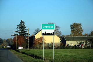
Grędzice is a village in the administrative district of Gmina Szulborze Wielkie, within Ostrów Mazowiecka County, Masovian Voivodeship, in east-central Poland. It lies approximately 3 kilometres (2 mi) west of Szulborze Wielkie, 21 km (13 mi) east of Ostrów Mazowiecka, and 101 km (63 mi) north-east of Warsaw.
Nowokrasne is a village in the administrative district of Gmina Krasne, within Przasnysz County, Masovian Voivodeship, in east-central Poland.
Kochany is a village in the administrative district of Gmina Wodynie, within Siedlce County, Masovian Voivodeship, in east-central Poland. It lies approximately 10 kilometres (6 mi) south-west of Wodynie, 33 km (21 mi) south-west of Siedlce, and 67 km (42 mi) south-east of Warsaw.
Jabłonowo is a village in the administrative district of Gmina Sieraków, within Międzychód County, Greater Poland Voivodeship, in west-central Poland. It lies approximately 7 kilometres (4 mi) east of Sieraków, 22 km (14 mi) east of Międzychód, and 57 km (35 mi) north-west of the regional capital Poznań.
Kalniszki is a village in the administrative district of Gmina Gołdap, within Gołdap County, Warmian-Masurian Voivodeship, in northern Poland, close to the border with the Kaliningrad Oblast of Russia. It lies approximately 18 kilometres (11 mi) south-west of Gołdap and 118 km (73 mi) north-east of the regional capital Olsztyn.
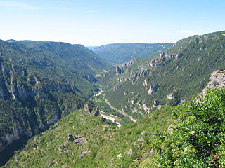
The Gorges du Tarn is a canyon formed by the Tarn between the Causse Méjean and the Causse de Sauveterre, in southern France. The canyon, mainly located in the Lozère département, and partially in the Aveyron département, is about 53 kilometres (33 mi)-long and 400 m to 600 m deep.
Gizajny is a village in the administrative district of Gmina Małdyty, within Ostróda County, Warmian-Masurian Voivodeship, in northern Poland. It lies approximately 12 kilometres (7 mi) west of Małdyty, 34 km (21 mi) north-west of Ostróda, and 62 km (39 mi) west of the regional capital Olsztyn.
Drahimek is a village in the administrative district of Gmina Czaplinek, within Drawsko County, West Pomeranian Voivodeship, in north-western Poland. It lies approximately 8 kilometres (5 mi) north of Czaplinek, 28 km (17 mi) east of Drawsko Pomorskie, and 109 km (68 mi) east of the regional capital Szczecin.

Danci is a village in the municipality of Kakanj, Bosnia and Herzegovina.


