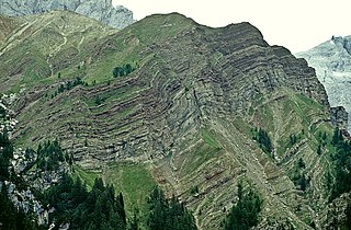
The Alps form part of a Cenozoic orogenic belt of mountain chains, called the Alpide belt, that stretches through southern Europe and Asia from the Atlantic all the way to the Himalayas. This belt of mountain chains was formed during the Alpine orogeny. A gap in these mountain chains in central Europe separates the Alps from the Carpathians to the east. Orogeny took place continuously and tectonic subsidence has produced the gaps in between.

The Helvetic zone, Helvetic system or the Helveticum is a geologic subdivision of the Alps. The Helvetic zone crops out mainly in Switzerland, hence the name. Rocks in the Helvetic zone are sedimentary and were originally deposited at the southern margin of the European plate. The Helvetic zone correlates with the French Dauphinois zone, French geologists often prefer the French name but normally this is considered the same thing.

The Penninic nappes or the Penninicum, commonly abbreviated as Penninic, are one of three nappe stacks and geological zones in which the Alps can be divided. In the western Alps the Penninic nappes are more obviously present than in the eastern Alps, where they crop out as a narrow band. The name Penninic is derived from the Pennine Alps, an area in which rocks from the Penninic nappes are abundant.

The Aarmassif or Aaremassif is a geologic massif in the Swiss Alps. It contains a number of large mountain chains and parts of mountain chains.

The Bündner schist or Bündner slate is a collective name for schistose rocks that form a number of geologic formations in the Penninic nappes of the Alps. Bündner schists were originally marine sediments that underwent metamorphism at large depths.

The geology of the Iberian Peninsula consists of the study of the rock formations on the Iberian Peninsula, which includes Spain, Portugal, Andorra, and Gibraltar. The peninsula contains rocks from every geological period from the Ediacaran to the Quaternary, and many types of rock are represented. World-class mineral deposits are also found there.

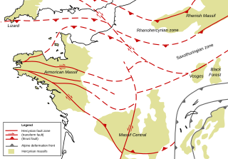
The Armorican Massif is a geologic massif that covers a large area in the northwest of France, including Brittany, the western part of Normandy and the Pays de la Loire. It is important because it is connected to Dover on the British side of the English Channel and there has been tilting back and forth that has controlled the geography on both sides.

The Saxothuringian Zone, Saxo-Thuringian zone or Saxothuringicum is in geology a structural or tectonic zone in the Hercynian or Variscan orogen of central and western Europe. Because rocks of Hercynian age are in most places covered by younger strata, the zone is not everywhere visible at the surface. Places where it crops out are the northern Bohemian Massif, the Spessart, the Odenwald, the northern parts of the Black Forest and Vosges and the southern part of the Taunus. West of the Vosges terranes on both sides of the English Channel are also seen as part of the zone, for example the Lizard complex in Cornwall or the Léon Zone of the Armorican Massif (Brittany).

The Mid-German Crystalline High is a structural high in the Paleozoic geology of Germany. The high forms a northeast-southwest oriented zone through Germany, but actual rock outcrops are sparse since Paleozoic basement rocks are in most of central Germany overlain by younger sedimentary rocks. The Mid-German Crystalline High crops out in the Odenwald, the Spessart, the northern Vosges and some small other massifs.

The Moldanubian Zone is in the regional geology of Europe a tectonic zone formed during the Variscan or Hercynian Orogeny. The Moldanubian Zone crops out in the Bohemian Massif and the southern part of the Black Forest and Vosges and contains the highest grade metamorphic rocks of Variscan age in Europe.

The Western Carpathians are an arc-shaped mountain range, the northern branch of the Alpine-Himalayan fold and thrust system called the Alpide belt, which evolved during the Alpine orogeny. In particular, their pre-Cenozoic evolution is very similar to that of the Eastern Alps, and they constitute a transition between the Eastern Alps and the Eastern Carpathians.
The Massif Central is one of the two large basement massifs in France, the other being the Armorican Massif. The Massif Central's geological evolution started in the late Neoproterozoic and continues to this day. It has been shaped mainly by the Caledonian orogeny and the Variscan orogeny. The Alpine orogeny has also left its imprints, probably causing the important Cenozoic volcanism. The Massif Central has a very long geological history, underlined by zircon ages dating back into the Archaean 3 billion years ago. Structurally it consists mainly of stacked metamorphic basement nappes.
The Thiviers-Payzac Unit is a metasedimentary succession of late Neoproterozoic and Cambrian age outcropping in the southern Limousin in France. The unit geologically forms part of the Variscan basement of the northwestern Massif Central.

The geology of Germany is heavily influenced by several phases of orogeny in the Paleozoic and the Cenozoic, by sedimentation in shelf seas and epicontinental seas and on plains in the Permian and Mesozoic as well as by the Quaternary glaciations.
The Tuhua orogeny was a regional orogeny between 370 and 330 million years ago, now preserved in the Fiordland region of New Zealand. Early Paleozoic rocks such as Ordovician greywacke, slate and paragneiss in the Buller terrane, weakly metamorphosed greenschist and sub-greenschist rocks, Cambrian mafic volcanics, Ordovician limestone and Silurian clastic rocks were all deformed and metamorphosed. In addition, between 380 and 250 million years ago, metasediments reached amphibolite grade in the sequence of metamorphic facies.

The geology of Bosnia & Herzegovina is the study of rocks, minerals, water, landforms and geologic history in the country. The oldest rocks exposed at or near the surface date to the Paleozoic and the Precambrian geologic history of the region remains poorly understood. Complex assemblages of flysch, ophiolite, mélange and igneous plutons together with thick sedimentary units are a defining characteristic of the Dinaric Alps, also known as the Dinaride Mountains, which dominate much of the country's landscape.

The geology of Sweden is the regional study of rocks, minerals, tectonics, natural resources and groundwater in the country. The oldest rocks in Sweden date to more than 2.5 billion years ago in the Precambrian. Complex orogeny mountain building events and other tectonic occurrences built up extensive metamorphic crystalline basement rock that often contains valuable metal deposits throughout much of the country. Metamorphism continued into the Paleozoic after the Snowball Earth glaciation as the continent Baltica collided with an island arc and then the continent Laurentia. Sedimentary rocks are most common in southern Sweden with thick sequences from the last 250 million years underlying Malmö and older marine sedimentary rocks forming the surface of Gotland.

The geology of North Macedonia includes the study of rocks dating to the Precambrian and a wide array of volcanic, sedimentary and metamorphic rocks formed in the last 539 million years.

The geology of Bulgaria consists of two major structural features. The Rhodope Massif in southern Bulgaria is made up of Archean, Proterozoic and Cambrian rocks and is a sub-province of the Thracian-Anatolian polymetallic province. It has dropped down, faulted basins filled with Cenozoic sediments and volcanic rocks. The Moesian Platform to the north extends into Romania and has Paleozoic rocks covered by rocks from the Mesozoic, typically buried by thick Danube River valley Quaternary sediments. In places, the Moesian Platform has small oil and gas fields. Bulgaria is a country in southeastern Europe. It is bordered by Romania to the north, Serbia and North Macedonia to the west, Greece and Turkey to the south, and the Black Sea to the east.

The geology of Italy includes mountain ranges such as the Alps and the Apennines formed from the uplift of igneous and primarily marine sedimentary rocks all formed since the Paleozoic. Some active volcanoes are located in Insular Italy.


