Grace Bank Barcadares | |
---|---|
Hamlet | |
Etymology: embarcadero | |
Coordinates: 17°39′04″N88°23′59″W / 17.651079886603995°N 88.39969159699486°W | |
Country | Belize |
District | Belize |
Settled | 1650s (as capital) |
Relocated | 1760 (to St. George's Caye) |
Resettled | 1763 (as hamlet) |
Renamed | 19th cent. (Grace Bank) |
Named for | an embarcadero(former) resident named Grace(current) |
Government | |
• Type | Town meeting (to 1760) Unincorporated hamlet (1763–present) |
• Body | Public meeting (to 1760) None (1763–present) |
Area | |
• Total | 1 sq mi (3 km2) |
• Land | 0.4 sq mi (1 km2) |
• Water | 0.6 sq mi (2 km2) |
Elevation | 15 ft (5 m) |
Population (2010) | |
• Total | 49 |
• Density | 49/sq mi (19/km2) |
Demonym | Baymen (formerly) |
Time zone | UTC−6 (GMT−6) |
Grace Bank, formerly Barcadares, is an unincorporated hamlet 33 miles up the Belize River. It was the second settlement founded by the first English settlers of present-day Belize. It was settled in the 1650s, relocated in 1760, and resettled in 1853.
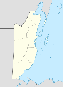
Grace Bank's immediate surroundings were likely first settled by nomadic Paleo-Indians prior to the 8th millennium BC, during the Lithic period in Mesoamerica. [1] [2] [3] [note 1] Mayan farmers founded permanent settlements in the area by the 2nd millennium BC, during the Archaic period in Mesoamerica. [4] [5] By the 16th century, the region formed part of Dzuluinicob, a Postclassic Mayan state. [6]
Sixteenth century residents of the area first became aware of Spaniards in 1502, with the 30 July landing of Christopher Columbus in Guanaja. [note 2] On 8 December 1526, Francisco de Montejo was named adelantado of the Yucatán Peninsula (including the territory of Dzuluinicob). [7] [8] The Spanish conquest reached the area in the third quarter of 1528, during Montejo's southern entrada. [9] [10] Said conquest lasted until the first or second quarter of 1544, upon Melchor and Alonso Pacheco's defeat of Chetumal and Dzuluinicob, and their subsequent founding of Bacalar. [11] [12] [13] Some or most of the area's surviving residents were (forcibly) relocated to reducción towns closer to Bacalar, and (forcibly) converted to Roman Catholicism. [note 3]
A secular parish was (belatedly) established at Bacalar in 1565 by Pedro de la Costa. [14] In the latter three quarters of 1568, an entrada and reducción by Juan de Garzón and the vecinos of Bacalar resulted in the further disintegration of Postclassic Mayan society in the area, thereby cementing Spanish dominion from Bacalar. [15] [16] [note 4]
Bacalar began to lose control over its district in c. 1615, as alcaldes ordinarios were forced to re-establish reducción towns near Tipu in 1615, to conduct a visita in 1620. [17] [note 5] In 1638, Tipu lead the area into general revolt against Bacalar, resulting in the collapse of Spanish power over the region by 1642, and the relocation of a majority of the area's residents to Tipu. [18] [19] [20] [21] [22] [23] [note 6]
Pirates are first thought to have arrived near Grace Bank in 1617, during a raid of Bacalar by English pirates or privateers. [24] [note 7] In the 1630s, pirates were further attracted to the region by the increasing willingness of Spanish residents to trade with non-Spaniards, and the possibility of abducting Mayan residents for impressment or sale at non-Spanish slave markets. [25] [26] [27] [28] [29] [30] [note 8] Belize City is thought to have been settled in 1638, by a crew of shipwrecked buccaneers. [31] [32] [33] [34] [note 9]
In the 1540s, Marcos de Ayala Trujeque, a vecino of Merida, is thought to have pioneered the use of logwood dyes in the Old World. [35] The early buccaneer settlers (now Baymen) turned to logging logwood in the 1650s, when they are thought to have settled Grace Bank (then Barcadares). [36] [note 10]
Barcadares's settlers opened conflict against Bacalar on 29 May 1652, when they are thought to have lead or been involved in that villa's sacking. [37] [38] [note 11] Spanish Yucatan retaliated during 16 November 1694 – 28 February 1695 with a paramilitary campaign against the Baymen's camps and settlements, thereby presaging over a century of Anglo-Spanish conflict that would eventually lead to the relocation of Barcadares. [39] [40] This campaign lead to the first (of many) evacuations of the Baymen's settlements. [39] [40] [note 12] Spanish Yucatan also tightened its control of the waters off the Belize River beginning on 2 November 1705 with the arrival of privateers or guardacostas Archibaldo Magdonel de Narión and Francisco Joseph Jiménez with 30 men aboard two goletas. [41]
The final campaign against Barcadares occurred on 25 December 1759, when 150 Spaniards aboard a 'great number' of periaguas landed in the port of Belize. This coup de grâce resulted in the imprisonment of a number of Baymen, the seizure of several loaded flats, the burning of Barcadares and nearby logging camps, and a nearly three-year evacuation of all settlements (in favour of the safer Mosquito Shore). [42] [43] [note 13]
Grace Bank is not known to have been settled by Mayans. [44] [note 14] The area is thought to have formed part of Dzuluinicob from the 10th or 12th century to c. 1544. [45] [46] [47] [note 15] It was a de jure part of the municipio or district of Bacalar, in Yucatan, a province of New Spain, until 15 September 1821. [note 16] It was a de facto part of the English settlement in the Bay of Honduras from the 1650s to 11 February 1862, and thereafter a de jure and de facto part of British Honduras. It is presently part of the Belize District of Belize.
Grace Bank lies on the northern bank of the Belize River, near its confluence with Francisco Creek, some eight or nine miles inland (as the crow flies) from the Caribbean Sea. It is 33 miles up the river, past Davis Bank, just before Lime Walk. It lies just south of Jones Lagoon, and west of Potts Creek Lagoon. [48]
Grace Bank has a tropical monsoon climate (Köppen climate classification Am), with a May – November wet and a December – April dry season.
This section needs expansion. You can help by adding to it. (April 2022) |
Grace Bank is currently part of the Belize Rural South constituency, and is represented in Parliament by Marconi Leal MP.
This section needs expansion. You can help by adding to it. (April 2022) |
Chetumal is a city on the east coast of the Yucatán Peninsula in Mexico. It is the capital of the state of Quintana Roo and the municipal seat of the Municipality of Othón P. Blanco. In 2020 it had a population of 169,028 people.
Bacalar is the municipal seat and largest city in Bacalar Municipality in the Mexican state of Quintana Roo, about 40 kilometres (25 mi) north of Chetumal. In the 2010 census the city had a population of 11,084. At that time it was still part of Othón P. Blanco, and was its second-largest city (locality), after Chetumal.
The Madrid Codex is one of three surviving pre-Columbian Maya books dating to the Postclassic period of Mesoamerican chronology. The Madrid Codex is held by the Museo de América in Madrid and is considered to be the most important piece in its collection. However, the original is not on display due to its fragility; an accurate reproduction is displayed in its stead. At one point in time the codex was split into two pieces, given the names "Codex Troano" and "Codex Cortesianus". In the 1880s, Leon de Rosny, an ethnologist, realised that the two pieces belonged together, and helped combine them into a single text. This text was subsequently brought to Madrid, and given the name "Madrid Codex", which remains its most common name today.
Yucatec Maya is a Mayan language spoken in the Yucatán Peninsula, including part of northern Belize. There is also a significant diasporic community of Yucatec Maya speakers in San Francisco, though most Maya Americans are speakers of other Mayan languages from Guatemala and Chiapas.
Belize, on the east coast of Central America, southeast of Mexico, was inhabited by the indigenous peoples who fought off the Spaniards in an attempt to preserve their heritage and to avoid the fate of their neighbors who were conquered and under Spanish rule. While this was going on, British pirates would rob Spanish merchant ships and navigate through the shallow waters and small islands even going up river later to hide their bounty. The indigenous people of Belize did not resist the British like they did the Spanish. In the 17th century, however, the British settlement became a formal British crown colony from 1862 through 1964, where they first achieved self government and later in 1981 became an independent country recognized globally with all its territory intact. The British brought along with them slaves taken from Congo and Angola during the eighteenth century.
The Province of Yucatán, or the Captaincy General, Governorate, Intendancy, or Kingdom of Yucatán, was a first order administrative subdivision of the Viceroyalty of New Spain in the Yucatán Peninsula.
Nohmul is a pre-Columbian Maya archaeological site located on the eastern Yucatán Peninsula, in what is today northern Belize. The name Nohmul may be translated as "great mound" in Yucatec Maya. It is the most important Maya site in northern Belize. The site included a large pyramid, about 17 meters (56 ft) tall, built around 250 BC. Most of the pyramid was destroyed in May 2013 by contractors tearing it apart for rocks and gravel to use to fill roads, leaving only the core of the pyramid behind.
The Spanish conquest of Petén was the last stage of the conquest of Guatemala, a prolonged conflict during the Spanish colonisation of the Americas. A wide lowland plain covered with dense rainforest, Petén contains a central drainage basin with a series of lakes and areas of savannah. It is crossed by several ranges of low karstic hills and rises to the south as it nears the Guatemalan Highlands. The conquest of Petén, a region now incorporated into the modern republic of Guatemala, climaxed in 1697 with the capture of Nojpetén, the island capital of the Itza kingdom, by Martín de Ursúa y Arizmendi. With the defeat of the Itza, the last independent and unconquered native kingdom in the Americas fell to European colonisers.
The history of Maya civilization is divided into three principal periods: the Preclassic, Classic and Postclassic periods; these were preceded by the Archaic Period, which saw the first settled villages and early developments in agriculture. Modern scholars regard these periods as arbitrary divisions of chronology of the Maya civilization, rather than indicative of cultural evolution or decadence. Definitions of the start and end dates of period spans can vary by as much as a century, depending on the author. The Preclassic lasted from approximately 3000 BC to approximately 250 AD; this was followed by the Classic, from 250 AD to roughly 950 AD, then by the Postclassic, from 950 AD to the middle of the 16th century. Each period is further subdivided:
Chetumal, or the Province of Chetumal, was a Postclassic Maya state of the Yucatan Peninsula, in the Maya Lowlands.
Peter Wallace is commonly held to have been an English or Scottish buccaneer who, in 1638 aboard the Swallow, founded the first English settlement in present-day Belize. Wallace's historicity is debated, first emerging in the 1829 Honduras Almanack; however, several scholars deem him a legendary protagonist of the country's founding myth, rather than an actual historical figure.
Dzuluinicob, or the Province of Dzuluinicob or Ts'ulwinikob, was a Postclassic Maya state in the Yucatán Peninsula of the Maya Lowlands.
Pirates, privateers, corsairs, and buccaneers were active in the Bay of Honduras from the 1540s to the 1860s. This is an annotated, chronological list of such events, with sortable tables provided.
The Anglo-Saxon, English, or Baymen's settlement of Belize is traditionally thought to have been effected upon Peter Wallace's 1638 landing at the mouth of Haulover Creek. As this account lacks clear primary sources, however, scholarly discourse has tended to qualify, amend, or completely eschew said theory, giving rise to a myriad competing narratives of the English settling of Belize. Though none of the aforementioned have garnered widespread consensus, historical literature has tended to favour a circumspect account of a landing near Haulover sometime during the 1630s and 1660s, effected by logwood-seeking, haven-seeking, or shipwrecked buccaneers.
The 1638 Tipu rebellion was a widespread revolt of Maya residents in the municipio or district of Bacalar in the second half of 1638. Led by Tipu, a pre-Columbian town and the most significant reducción or encomienda settlement in the district, it resulted in the removal of Bacalar and subsequent collapse of Spanish power in the region, leading to a 57-year revival of the Postclassic state of Dzuluinicob, of which Tipu had been capital.
The 1543–1544 Pachecos entrada was the final military campaign in the Spanish conquest of Yucatán, which brought three Postclassic Maya states and several Amerindian settlements in the southeastern quarter of the Yucatán Peninsula under the jurisdiction of Salamanca de Bacalar, a villa of colonial Yucatán, in New Spain. It is commonly deemed one of bloodiest and cruelest entradas in the peninsula's conquest, resulting in the deaths of hundreds or thousands, and the displacement of tens of thousands, of Maya residents.
The Preceramic Period of Belizean and Mesoamerican history began with the arrival of the first Palaeoindians during 20000 BC – 11000 BC, and ended with the Maya development of ceramics during 2000 BC – 900 BC.
The Preclassic or Formative Period of Belizean, Maya, and Mesoamerican history began with the Maya development of ceramics during 2000 BC – 900 BC, and ended with the advent of Mayan monumental inscriptions in 250 AD.
The periodisation of the history of Belize is the division of Belizean, Maya, and Mesoamerican history into named blocks of time, spanning the arrival of Palaeoindians to the present time. The pre-Columbian era is most often periodised by Mayanists, who often employ four or five periods to discuss history prior to the arrival of Spaniards. The Columbian era is most often periodised by historians, and less often by Mayanists, who often employ at least four periods to discuss history up to the present time.
The Maya Lowlands are the largest cultural and geographic, first order subdivision of the Maya Region, located in eastern Mesoamerica.
{{cite map}}
: CS1 maint: year (link)