Grade II listed buildings in Southampton: T–Z

Last updated

In total there are 317 [1] listed buildings in the city of Southampton, of which 13 are Grade I, 20 are Grade II* and the remainder Grade II.

Contents

In England, a building or structure is defined as "listed" when it is placed on a statutory register of buildings of "special architectural or historic interest" by the Secretary of State for Culture, Media and Sport, a Government department, in accordance with the Planning (Listed Buildings and Conservation Areas) Act 1990. [2] English Heritage, a non-departmental public body, acts as an agency of this department to administer the process and advise the department on relevant issues. [3] There are three grades of listing status. The Grade II designation is the lowest, and is used for "nationally important buildings of special interest". [4] Grade II* is used for "particularly important buildings of more than special interest", while Grade I (defined as being of "exceptional interest" and greater than national importance), is the highest of the three grades. [4]

This list summarises 32 Grade II-listed buildings and structures whose names begin with T to Z. Numbered buildings with no individual name are listed by the name of the street on which they stand.

Map all coordinates using: OpenStreetMap  
Download coordinates as: KML

Listed buildings

NamePhotographDateLocation [A] Description [B] Link to English Heritage database [C] Link to Images of England database [D] Link to British Listed Buildings database [E]
Terminus Station Goods Shedmid 19th century SU4270511126
50°53′53″N1°23′39″W / 50.8980°N 1.3941°W / 50.8980; -1.3941 (Terminus Station Goods Shed)
63 Test Laneearly 18th century SU3705113720
50°55′18″N1°28′27″W / 50.9218°N 1.4742°W / 50.9218; -1.4742 (63 Test Lane)
65 Test Laneearly 18th century SU3705313715
50°55′18″N1°28′27″W / 50.9217°N 1.4742°W / 50.9217; -1.4742 (65 Test Lane)
Thorner's Homes1932 SU3959313638
50°55′15″N1°26′17″W / 50.9208°N 1.4381°W / 50.9208; -1.4381 (Thorner's Homes)
Not listedNot listed
Titanic Engineers' Memorial Titanic Engineers' Memorial, Southampton.jpg 1912 SU4195812471
50°54′37″N1°24′17″W / 50.9102°N 1.4046°W / 50.9102; -1.4046 (Titanic Engineers' Memorial)
Tower House God's House on Town Quay Road - geograph.org.uk - 1721989.jpg 18th to 19th century SU4207610926
50°53′47″N1°24′11″W / 50.8963°N 1.4031°W / 50.8963; -1.4031 (Tower House)
Town Quay - Pair of K6 telephone kiosks Southampton City Walls - geograph.org.uk - 1744178.jpg 1935 SU4196510975
50°53′48″N1°24′17″W / 50.8967°N 1.4046°W / 50.8967; -1.4046 (Town Quay telephone kiosks)
A pair of standard K6 style telephone booths designed by Giles Gilbert Scott. They are glazed on all four sides, built of red-painted cast iron and topped with a shallow dome-style roof.
Town Walls: Eastern section Friary Gate - Southampton City Wall - geograph.org.uk - 23031.jpg 14th century SU4210311060
50°53′51″N1°24′10″W / 50.8975°N 1.4027°W / 50.8975; -1.4027 (Southampton Town Walls: Eastern section)
Section of wall running along Back of the Walls to Briton Street. Remains of mediaeval city walls. Rubble walls from 5 to 8 feet in height.
Town Walls: Fragment near East Street14th century SU4214911503
50°54′05″N1°24′07″W / 50.9015°N 1.4020°W / 50.9015; -1.4020 (Southampton Town Walls: Fragment)
Remains of mediaeval city walls. Built of stone rubble. About 8 feet in height.
Townhill Park House Thegreggschool-southampton-UK.jpg 1795 SU4518015064
50°56′00″N1°21′30″W / 50.9333°N 1.3584°W / 50.9333; -1.3584 (Townhill Park House)
Townhill Park House - former Stable Blockca. 1830s SU4518315005
50°55′58″N1°21′30″W / 50.9327°N 1.3584°W / 50.9327; -1.3584 (Townhill Park House - former Stable Block)
Trafalgar Dry Dock1905 SU4222610658
50°53′38″N1°24′04″W / 50.8939°N 1.4010°W / 50.8939; -1.4010 (Trafalgar Dry Dock)
Tudor House Museum – Archway from St. Denys Priory14th century SU4182811277
50°53′58″N1°24′24″W / 50.8995°N 1.4066°W / 50.8995; -1.4066 (Archway from St. Denys Priory)
Tudor House Museum – Two carved stone pedestals1743 SU4184111275
50°53′58″N1°24′23″W / 50.8994°N 1.4064°W / 50.8994; -1.4064 (Tudor House Museum - Two carved stone pedestals)
Union Castle House Union-Castle House - geograph.org.uk - 1722354.jpg 1847 SU4246910983
50°53′48″N1°23′51″W / 50.8968°N 1.3975°W / 50.8968; -1.3975 (Union Castle House)
1 Vespasian Roadmid 19th century SU4369013576
50°55′12″N1°22′47″W / 50.9200°N 1.3798°W / 50.9200; -1.3798 (1 Vespasian Road)
Water Gate Tower Southampton Town Walls, tower standing by the former Water Gate.jpg 14th and 15th century SU4197210976
50°53′48″N1°24′16″W / 50.8967°N 1.4045°W / 50.8967; -1.4045 (Water Gate Tower)
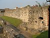
The remains of the Watergate, the south gate of the town comprising a drum tower of three storeys and part of fourth storey with three arched windows. Scheduled as an ancient monument.
Watts Monument Sir Isaac Watts, Watts Park, Southampton - geograph.org.uk - 1727766.jpg 1861 SU4184212402
50°54′35″N1°24′22″W / 50.9096°N 1.4062°W / 50.9096; -1.4062 (Watts Monument)
Weigh House Vaultlate 14th century SU4193311117
50°53′53″N1°24′18″W / 50.8980°N 1.4051°W / 50.8980; -1.4051 (Weigh House Vault)
Westfield Houseearly 19th century SU4416515985
50°56′30″N1°22′22″W / 50.9416°N 1.3728°W / 50.9416; -1.3728 (Westfield House)
8 Westgate Street 18th century SU4181011225
50°53′56″N1°24′24″W / 50.8990°N 1.4068°W / 50.8990; -1.4068 (8 Westgate Street)
9 & 10 Westgate Street Tudor Merchant's Hall - geograph.org.uk - 1428497.jpg early 19th century SU4181611222
50°53′56″N1°24′24″W / 50.8990°N 1.4067°W / 50.8990; -1.4067 (9 & 10 Westgate Street)
Wight House 'Chambers' on Canute Road - geograph.org.uk - 1722496.jpg 1896 SU4265210996
50°53′49″N1°23′42″W / 50.8969°N 1.3949°W / 50.8969; -1.3949 (Wight House)
1 to 4 Winkle Street mid 19th century SU4206310948
50°53′47″N1°24′12″W / 50.8965°N 1.4033°W / 50.8965; -1.4033 (1 to 4 Winkle Street)
5 to 8 Winkle Streetmid 19th century SU4205110973
50°53′48″N1°24′12″W / 50.8967°N 1.4034°W / 50.8967; -1.4034 (5 to 8 Winkle Street)
Woodmill bridge Woodmill Bridge, Southampton - geograph.org.uk - 26911.jpg early 18th century SU4392215223
50°56′05″N1°22′35″W / 50.9348°N 1.3763°W / 50.9348; -1.3763 (Woodmill bridge)
Woodmill fish houselate 18th or early 19th century SU4389615292
50°56′07″N1°22′36″W / 50.9354°N 1.3767°W / 50.9354; -1.3767 (Woodmill fish house)
Woodmill Lane drinking fountain1897 SU4424115046
50°56′00″N1°22′18″W / 50.9332°N 1.3718°W / 50.9332; -1.3718 (Woodmill Lane drinking fountain)
Woolston railway station WlstnRS200.jpg ca. 1860 SU4390911234
50°53′56″N1°22′37″W / 50.8989°N 1.3770°W / 50.8989; -1.3770 (Woolston railway station)
Woolwich House Southampton High Street - geograph.org.uk - 621107.jpg 1850–1860 SU4204311328
50°54′00″N1°24′13″W / 50.8999°N 1.4035°W / 50.8999; -1.4035 (Woolwich House)
[ permanent dead link ]
The Stables, Wrights Hillmid 19th century SU4505610727
50°53′39″N1°21′39″W / 50.8943°N 1.3607°W / 50.8943; -1.3607 (The Stables, Wrights Hill)
Wyndham Court Wyndham Court, Southampton - geograph.org.uk - 408226.jpg 1966–1969 SU4149912264
50°54′30″N1°24′40″W / 50.9084°N 1.4111°W / 50.9084; -1.4111 (Wyndham Court)

Notes

Related Research Articles

Listed building Protected historic structure in the United Kingdom

A listed building, or listed structure, is one that has been placed on one of the four statutory lists maintained by Historic England in England, Historic Environment Scotland in Scotland, Cadw in Wales, and the Northern Ireland Environment Agency in Northern Ireland.

The Register of Historic Parks and Gardens of Special Historic Interest in England provides a listing and classification system for historic parks and gardens similar to that used for listed buildings. The register is managed by Historic England under the provisions of the National Heritage Act 1983. Over 1,600 sites are listed, ranging from the grounds of large stately homes to small domestic gardens, as well other designed landscapes such as town squares, public parks and cemeteries.

Grade I listed buildings in City of Bradford

This is a list of the grade I listed buildings in the City of Bradford. In the United Kingdom, the term listed building refers to a building or other structure officially designated as being of special architectural, historical or cultural significance; Grade I structures are those on account of their special architectural or historic interest. In England, the authority for listing under the Planning Act 1990 rests with English Heritage, a non-departmental public body sponsored by the Department for Culture, Media and Sport.

Grade I listed buildings in the East Riding of Yorkshire

There are over 9,300 Grade I listed buildings in England. This page is a list of the 111 of these buildings in the ceremonial county of the East Riding of Yorkshire. In the United Kingdom, the term listed building refers to a building or other structure officially designated as being of special architectural, historical or cultural significance; Grade I structures are those considered to be "buildings of exceptional interest". In England, the authority for listing under the Planning Act 1990 rests with Historic England, a non-departmental public body sponsored by the Department for Culture, Media and Sport.

There are over 9,300 Grade I listed buildings in England. This page is a list of these buildings in the county of Isle of Wight.

Grade I listed buildings in Tyne and Wear

There are 75 Grade I listed buildings in Tyne and Wear, England.

Grade I listed buildings in Ipswich

There are 11 Grade I listed buildings in Ipswich, a non-metropolitan district and the county town of Suffolk, England.

Grade I listed buildings in Forest Heath

There are 12 Grade I listed buildings in Forest Heath, a non-metropolitan district of Suffolk, England.

In total there are 317 listed buildings in the city of Southampton, of which 15 are Grade I, 20 are Grade II* and the remainder Grade II.

In total there are 317 listed buildings in the city of Southampton, of which 14 are Grade I, 20 are Grade II* and the remainder Grade II.

In total there are 317 listed buildings in the city of Southampton, of which 14 are Grade I, 20 are Grade II* and the remainder Grade II.

In total there are 317 listed buildings in the city of Southampton, of which 14 are Grade I, 20 are Grade II* and the remainder Grade II.

In total there are 317 listed buildings in the city of Southampton, of which 14 are Grade I, 20 are Grade II* and the remainder Grade II.

In total there are 317 listed buildings in the city of Southampton, of which 14 are Grade I, 20 are Grade II* and the remainder Grade II.

In total there are 317 listed buildings in the city of Southampton, of which 14 are Grade I, 20 are Grade II* and the remainder Grade II.

Grade II* listed buildings in Folkestone and Hythe

There are a number of Grade II* listed buildings in the district of Folkestone and Hythe in Kent.

Grade I listed buildings in Folkestone and Hythe

There are a number of Grade I listed buildings in the district of Shepway in Kent.

The county of West Sussex in South East England has 176 Grade I listed buildings. Such buildings are described by English Heritage, the authority responsible for their designation, as "of exceptional interest [and] sometimes considered to be internationally important". Grade I is the highest of the three grades of listed status in England: about 2.5% of the country's 374,000 listed buildings have this designation.

Grade II* listed buildings in Stoke-on-Trent

Stoke-on-Trent is a city located in Staffordshire, England. The city is a linear conurbation of six constituent towns. Stoke-on-Trent is considered to be the home of the pottery industry in England and is commonly known as the Potteries. Formerly a primarily industrial conurbation, it is now a centre for service industries and distribution centres.

References

  1. Calculated from a count of the entries on Southampton City Council's "Listed Buildings in Southampton" Archived 2008-10-01 at the Wayback Machine dated 9 January 2012, with duplicate entries eliminated.
  2. "Planning (Listed Buildings and Conservation Areas) Act 1990 (c. 9)". The UK Statute Law Database. Ministry of Justice. 14 January 2010. Archived from the original on 18 April 2010. Retrieved 17 March 2012.
  3. "How we are run". English Heritage. 2012. Retrieved 17 March 2012.
  4. 1 2 "Listed Buildings". English Heritage. 2010. Archived from the original on 26 January 2013. Retrieved 17 March 2012.
  5. "Guide to National Grid". Ordnance Survey. 2012. Archived from the original on 27 October 2007. Retrieved 5 February 2012.

Sources