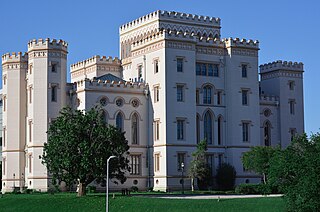
Baton Rouge is the capital city of the U.S. state of Louisiana. Located on the eastern bank of the Mississippi River, it had a population of 227,470 as of 2020; it is the seat of Louisiana's most populous parish (county-equivalent), East Baton Rouge Parish, and the center of Louisiana's second-largest metropolitan area, Greater Baton Rouge.

Natchitoches Parish is a parish located in the U.S. state of Louisiana. As of the 2020 census, the population was 37,515. The parish seat is Natchitoches. The parish was formed in 1805.

East Feliciana Parish is a parish located in the U.S. state of Louisiana. At the 2020 census, the population was 19,531. The parish seat is Clinton.

Calcasieu Parish is a parish located on the southwestern border of the U.S. state of Louisiana. As of the 2020 census, the population was 216,785. The parish seat is Lake Charles.
Moss Bluff is a census-designated place (CDP) in Calcasieu Parish, Louisiana, United States. The population was 12,522 at the 2020 census. Located just north of the city of Lake Charles, it is considered a suburb of that city. Moss Bluff is a burgeoning community, and is one of the communities in Calcasieu Parish besides Lake Charles and Sulphur experiencing growth. Several efforts have been made to incorporate Moss Bluff, but at the present time the community is unincorporated.

Vinton is a town in Calcasieu Parish, Louisiana, United States. The population was 3,400 in 2020. It is part of the Lake Charles metropolitan statistical area.

USS Choctaw was a large (1,004-ton) steamer built for the merchant service, but acquired by the Union Navy during the second year of the American Civil War.

U.S. Route 79 is a United States highway in the Southern United States. The route is officially considered and labeled as a north–south highway, but its path is actually more of a diagonal northeast–southwest highway. The highway's northern/eastern terminus is in Russellville, Kentucky, at an intersection with U.S. Route 68 and KY 80. Its southern/western terminus is in Round Rock, Texas, at an interchange with Interstate 35, ten miles (16 km) north of Austin. US 79, US 68, and Interstate 24/US 62 are the primary east–west access points for the Land Between the Lakes recreation area straddling the Kentucky/Tennessee border.

U.S. Route 65 is a north–south United States highway in the southern and midwestern United States. The southern terminus of the route is at U.S. Route 425 in Clayton, Louisiana. The northern terminus is at Interstate 35 just south of Interstate 90 in Albert Lea, Minnesota. Parts of its modern route in Iowa and historic route in Minnesota follow the old Jefferson Highway.

U.S. Route 63 (US 63) is a 1,286-mile (2,070 km), north–south United States Highway primarily in the Midwestern and Southern United States. The southern terminus of the route is at Interstate 20 (I-20) in Ruston, Louisiana; the northern terminus is at US 2 eight miles (13 km) west of Ashland, Wisconsin.

Southern University and A&M College is a public historically black land-grant university in Baton Rouge, Louisiana. It is the largest historically black college or university (HBCU) in Louisiana, a member-school of the Thurgood Marshall College Fund, and the flagship institution of the Southern University System. Its campus encompasses 512 acres, with an agricultural experimental station on an additional 372-acre site, five miles north of the main campus on Scott's Bluff overlooking the Mississippi River in the northern section of Baton Rouge.

Fort Atkinson was the first United States Army post to be established west of the Missouri River in the unorganized region of the Louisiana Purchase of the United States. Located just east of present-day Fort Calhoun, Nebraska, the fort was erected in 1819 and abandoned in 1827. The site is now known as Fort Atkinson State Historical Park and is a National Historic Landmark. A replica fort was constructed by the state at the site during the 1980s–1990s.

The Arkansas, Louisiana and Mississippi Railroad is a 52.9-mile (85.1 km) short-line railroad in northern Louisiana and southern Arkansas. Opened in 1908, it has undergone several corporate reorganizations, but has remained independent of larger carriers. In 2004, paper producer Georgia-Pacific sold the company to shortline operator Genesee & Wyoming Inc. Traffic generally consists of lumber, paper, forest products, and chemicals.
Gillis is an unincorporated community and census-designated place (CDP) in northern Calcasieu Parish, Louisiana, United States. As of the 2010 census it had a population of 657.
Ascension Parish School Board is a school district headquartered in Donaldsonville, Louisiana, United States.

The following outline is provided as an overview of and topical guide to the U.S. state of Arkansas:

KZWA is a radio station broadcasting an Urban Adult Contemporary format serving Lake Charles, Louisiana and licensed to Moss Bluff, Louisiana, United States. The station is currently owned by and licensed to B&C Broadcasting Ltd. The station's studios are located at the intersection of Enterprise Boulevard and I-10 just east of downtown Lake Charles, and its transmitter is southeast of Ragley, Louisiana.

The Supreme Court of the United States, under Chief Justice Roger B. Taney (1836–1864), issued several important decisions on the status of aboriginal title in the United States, building on the opinions of aboriginal title in the Marshall Court.
Bluff Creek is an unincorporated community in East Feliciana Parish, Louisiana, United States.
Horse Bluff Landing is an unincorporated community in Livingston Parish, Louisiana, United States. The community is located less than 3 miles west of Killian and 5 miles northeast of Maurepas on the bank of Tickfaw River. The Tickfaw State Park is located 1 mile to the northwest across the Tickfaw River.


