Ashland, Natchitoches Parish, Louisiana

Last updated

Ashland, Louisiana
Village of Ashland
Revised photo, Ashland, LA, Town Hall IMG 0736.JPG
Ashland Village Hall is located next to the United States Post Office building
Natchitoches Parish Louisiana Incorporated and Unincorporated areas Ashland Highlighted.svg
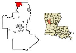
Location of Ashland in Natchitoches Parish, Louisiana.
Coordinates: 32°06′59″N93°06′53″W / 32.11639°N 93.11472°W / 32.11639; -93.11472
CountryUnited States
State Louisiana
Parish Natchitoches
Incorporated1963
Government
  MayorTerry Chesser (R)

Aldermen:
Nathan Cherry (D) Ann Anderson (R)

Josh Adams (R)
Area
[1]
  Total27.15 sq mi (70.31 km2)
  Land26.99 sq mi (69.90 km2)
  Water0.16 sq mi (0.42 km2)
Elevation
226 ft (69 m)
Population
 (2020)
  Total194
  Rank NC: 7th
  Density7.19/sq mi (2.78/km2)
Time zone UTC−6 (CST)
  Summer (DST) UTC−5 (CDT)
Area code 318
FIPS code 22-03145
GNIS feature ID2407410

Ashland is a village in the northernmost portion of Natchitoches Parish, Louisiana, United States. A few residences and a convenience store to the north spill over into neighboring Bienville Parish. The population was 291 at the 2000 census but declined nine percent to 269 in 2010. The median age was 45.7 years. [2] Ashland is part of the Natchitoches Micropolitan Statistical Area.

Contents

Geography

According to the United States Census Bureau, the village has a total area of 27.1 square miles (70 km2), of which 27.1 square miles (70 km2) is land and 0.04 square miles (0.10 km2) (0.07%) is water.

Climate

Climate is characterized by relatively high temperatures and evenly distributed precipitation throughout the year. According to the Köppen Climate Classification system, Ashland has a humid subtropical climate, abbreviated "Cfa" on climate maps. [3]

Climate data for Ashland, Louisiana (1991–2020 normals, extremes 1954–2014)
MonthJanFebMarAprMayJunJulAugSepOctNovDecYear
Record high °F (°C)82
(28)
87
(31)
89
(32)
92
(33)
97
(36)
103
(39)
107
(42)
108
(42)
110
(43)
97
(36)
90
(32)
84
(29)
110
(43)
Mean daily maximum °F (°C)57.7
(14.3)
61.9
(16.6)
69.2
(20.7)
76.1
(24.5)
82.6
(28.1)
89.2
(31.8)
92.0
(33.3)
93.0
(33.9)
88.0
(31.1)
78.3
(25.7)
68.3
(20.2)
59.4
(15.2)
76.3
(24.6)
Daily mean °F (°C)45.9
(7.7)
49.7
(9.8)
57.0
(13.9)
63.7
(17.6)
71.6
(22.0)
78.3
(25.7)
81.3
(27.4)
81.2
(27.3)
75.7
(24.3)
65.0
(18.3)
55.2
(12.9)
47.8
(8.8)
64.4
(18.0)
Mean daily minimum °F (°C)34.2
(1.2)
37.5
(3.1)
44.7
(7.1)
51.3
(10.7)
60.7
(15.9)
67.4
(19.7)
70.5
(21.4)
69.5
(20.8)
63.4
(17.4)
51.7
(10.9)
42.1
(5.6)
36.1
(2.3)
52.4
(11.3)
Record low °F (°C)−5
(−21)
10
(−12)
11
(−12)
24
(−4)
32
(0)
45
(7)
53
(12)
48
(9)
34
(1)
24
(−4)
14
(−10)
2
(−17)
−5
(−21)
Average precipitation inches (mm)5.38
(137)
5.24
(133)
5.56
(141)
5.25
(133)
4.63
(118)
4.00
(102)
3.81
(97)
3.18
(81)
3.92
(100)
4.56
(116)
4.99
(127)
6.18
(157)
56.70
(1,440)
Average snowfall inches (cm)0.1
(0.25)
0.3
(0.76)
0.0
(0.0)
0.0
(0.0)
0.0
(0.0)
0.0
(0.0)
0.0
(0.0)
0.0
(0.0)
0.0
(0.0)
0.0
(0.0)
0.0
(0.0)
0.1
(0.25)
0.5
(1.3)
Average precipitation days (≥ 0.01 in)8.88.28.46.76.77.27.76.26.26.67.38.388.3
Average snowy days (≥ 0.1 in)0.10.10.00.00.00.00.00.00.00.00.00.20.4
Source: NOAA [4] [5]

Demographics

Historical population
CensusPop.Note
1970 211
1980 28937.0%
1990 2890.0%
2000 2910.7%
2010 269−7.6%
2020 194−27.9%
U.S. Decennial Census [6]

2020 census

Ashland racial composition [7]
RaceNumberPercentage
White (non-Hispanic)16182.99%
Black or African American (non-Hispanic)2211.34%
Native American 21.03%
Other/Mixed 31.55%
Hispanic or Latino 63.09%

As of the 2020 United States census, there were 194 people, 77 households, and 57 families residing in the village.

2000 census

As of the census [8] of 2000, there were 291 people, 121 households, and 87 families residing in the village. The population density was 10.7 inhabitants per square mile (4.1/km2). There were 149 housing units at an average density of 5.5 per square mile (2.1/km2). The racial makeup of the village was 86.60% White, 10.31% African American, 2.41% Native American and 0.69% Asian. Hispanic or Latino of any race were 1.72% of the population.

There were 121 households, out of which 27.3% had children under the age of 18 living with them, 57.0% were married couples living together, 14.9% had a female householder with no husband present, and 27.3% were non-families. 25.6% of all households were made up of individuals, and 15.7% had someone living alone who was 65 years of age or older. The average household size was 2.40 and the average family size was 2.88.

In the village, the population was spread out, with 21.3% under the age of 18, 8.2% from 18 to 24, 26.5% from 25 to 44, 24.7% from 45 to 64, and 19.2% who were 65 years of age or older. The median age was 40 years. For every 100 females, there were 98.0 males. For every 100 females age 18 and over, there were 86.2 males.

The median income for a household in the village was $23,438, and the median income for a family was $31,875. Males had a median income of $27,083 versus $23,750 for females. The per capita income for the village was $12,652. About 33.7% of families and 32.0% of the population were below the poverty line, including 38.1% of those under the age of eighteen and 30.4% of those 65 or over.

Government

The Ashland mayor is Donna Holland Horn. The village council consists of two No Party members, Juanita Calhoun and Dorie Harp, and a Republican, Terry Chesser. [9] All of the Ashland town officials were unopposed for new terms in the primary election held on October 2, 2010.

See also

Related Research Articles

<span class="mw-page-title-main">Natchitoches Parish, Louisiana</span> Parish in Louisiana, United States

Natchitoches Parish is a parish located in the U.S. state of Louisiana. As of the 2020 census, the population was 37,515. The parish seat is Natchitoches. The parish was formed in 1805.

<span class="mw-page-title-main">Ashland, Alabama</span> City in and county seat of Clay County, Alabama

Ashland is a city in Clay County, Alabama, United States. The population was 2,037 at the 2010 census. The city is the county seat of Clay County.

<span class="mw-page-title-main">Ashland, Kansas</span> City in Clark County, Kansas

Ashland is a city in and the county seat of Clark County, Kansas, United States. As of the 2020 census, the population of the city was 783.

<span class="mw-page-title-main">Bienville, Louisiana</span> Village in Louisiana, United States

Bienville is a village in Bienville Parish, Louisiana, United States. The population was 218 at the 2010 census.

<span class="mw-page-title-main">Baskin, Louisiana</span> Village in Louisiana, United States

Baskin is a village in Franklin Parish, Louisiana, United States. The population was 254 at the 2010 census, up from 188 in 2000. Baskin is located north of the parish seat of Winnsboro.

<span class="mw-page-title-main">Gilbert, Louisiana</span> Village in Louisiana, United States

Gilbert is a village in Franklin Parish, Louisiana, United States. The population was 521 at the 2010 census.

<span class="mw-page-title-main">Delta, Louisiana</span> Village in Louisiana, United States

Delta is a village in Madison Parish, Louisiana, United States. The population was 232 at the 2020 census. It is part of the Tallulah Micropolitan Statistical Area.

<span class="mw-page-title-main">Campti, Louisiana</span> Town in Louisiana, United States

Campti is a town in the northern part of Natchitoches Parish, Louisiana, United States. The population was 1,056 at the 2010 census. It is part of the Natchitoches Micropolitan Statistical Area. Campti is a flat area of mostly farmland. It is located on the eastern bank of the Red River. Considerable herds of cattle are also raised in the general area.

<span class="mw-page-title-main">Clarence, Louisiana</span> Village in Louisiana, United States

Clarence is a village in Natchitoches Parish, Louisiana, United States. The population was 499 at the 2010 census. It is located some seven miles east of the parish seat of Natchitoches and is part of the Natchitoches Micropolitan Statistical Area.

<span class="mw-page-title-main">Goldonna, Louisiana</span> Village in Louisiana, United States

Goldonna is a village in Natchitoches Parish, Louisiana, United States. The population was 430 at the 2010 census. It is part of the Natchitoches Micropolitan Statistical Area. South of Goldonna along Louisiana Highway 156, one may access Saline Bayou, popular for blackwater canoeing.

<span class="mw-page-title-main">Natchez, Louisiana</span> Town in Louisiana, United States

Natchez is a town in Natchitoches Parish, Louisiana, United States. The population was 597 at the 2010 census. It is part of the Natchitoches Micropolitan Statistical Area. The village and parish are part of the Cane River National Heritage Area and located on Isle Brevelle.

<span class="mw-page-title-main">Powhatan, Louisiana</span> Village in Louisiana, United States

Powhatan is a village in Natchitoches Parish, Louisiana, United States. The population was 141 at the 2000 census. It is part of the Natchitoches Micropolitan Statistical Area.

<span class="mw-page-title-main">Provencal, Louisiana</span> Village in Louisiana, United States

Provencal is a village in Natchitoches Parish, Louisiana, United States. The population was 611 at the 2010 census. It is part of the Natchitoches Micropolitan Statistical Area.

<span class="mw-page-title-main">Robeline, Louisiana</span> Village

Robeline is a village in western Natchitoches Parish, Louisiana, United States. The population was 183 at the 2000 census. It is part of the Natchitoches Micropolitan Statistical Area.

<span class="mw-page-title-main">Many, Louisiana</span> Town in Louisiana, United States

Many is a town in, and the parish seat of Sabine Parish in western Louisiana, United States. The population was 2,853 at the 2010 census, a decrease of 36 or 1.246 percent from 2000.

<span class="mw-page-title-main">Simpson, Louisiana</span> Village in Louisiana, United States

Simpson is a village in Vernon Parish, Louisiana, United States. The population was 638 at the 2010 census. It is part of the Fort Polk South Micropolitan Statistical Area.

<span class="mw-page-title-main">Mifflin, Ohio</span> Village in Ohio, United States

Mifflin is a village in Mifflin Township, Ashland County, Ohio, United States. The population was 158 at the 2020 census.

<span class="mw-page-title-main">Polk, Ohio</span> Village in Ohio, United States

Polk is a village in Ashland County, Ohio, United States. The population was 310 at the 2020 census.

<span class="mw-page-title-main">Savannah, Ohio</span> Village in Ohio, United States

Savannah is a village in Ashland County, Ohio, United States. The population was 329 at the 2020 census.

<span class="mw-page-title-main">Yorkville, Ohio</span> Village in Ohio, United States

Yorkville is a village in Belmont and Jefferson counties in the U.S. state of Ohio. The population was 968 at the 2020 census. Yorkville lies within two Metropolitan Statistical Areas; the Belmont County portion is part of the Wheeling metropolitan area, while the Jefferson County portion is part of the Weirton–Steubenville metropolitan area.

References

  1. "2020 U.S. Gazetteer Files". United States Census Bureau. Retrieved March 20, 2022.
  2. "Ashland, LA". zip-codes.com. Retrieved July 5, 2012.
  3. Climate Summary for closest city on record
  4. "NOWData - NOAA Online Weather Data". National Oceanic and Atmospheric Administration. Retrieved November 2, 2023.
  5. "Summary of Monthly Normals 1991-2020". National Oceanic and Atmospheric Administration. Retrieved November 2, 2023.
  6. "Census of Population and Housing". Census.gov. Retrieved June 4, 2016.
  7. "Explore Census Data". data.census.gov. Retrieved December 29, 2021.
  8. "U.S. Census website". United States Census Bureau . Retrieved January 31, 2008.
  9. "Louisiana election returns, September 30, 2006". sos.louisiana.gov. Archived from the original on November 4, 2010. Retrieved October 5, 2010.