Readhimer | |
---|---|
Readhimer road sign | |
Coordinates: 32°6′56″N92°59′15″W / 32.11556°N 92.98750°W Coordinates: 32°6′56″N92°59′15″W / 32.11556°N 92.98750°W | |
Country | United States |
State | Louisiana |
Parish | Natchitoches |
Time zone | UTC-6 (Central (CST)) |
• Summer (DST) | UTC-5 (CDT) |
GNIS feature ID | 555761 [1] |
Readhimer is an unincorporated community in Natchitoches Parish, Louisiana, United States. It is located along Louisiana Highway 9 in far northeastern Natchitoches Parish to the northeast of the parish seat of Natchitoches.
In law, an unincorporated area is a region of land that is not governed by a local municipal corporation; similarly an unincorporated community is a settlement that is not governed by its own local municipal corporation, but rather is administered as part of larger administrative divisions, such as a township, parish, borough, county, city, canton, state, province or country. Occasionally, municipalities dissolve or disincorporate, which may happen if they become fiscally insolvent, and services become the responsibility of a higher administration. Widespread unincorporated communities and areas are a distinguishing feature of the United States and Canada. In most other countries of the world, there are either no unincorporated areas at all, or these are very rare; typically remote, outlying, sparsely populated or uninhabited areas.
Natchitoches Parish is a parish located in the U.S. state of Louisiana. As of the 2010 census, the population was 39,566. The parish seat is Natchitoches. The parish was formed in 1805.
Louisiana is a state in the Deep South region of the South Central United States. It is the 31st most extensive and the 25th most populous of the 50 United States. Louisiana is bordered by the state of Texas to the west, Arkansas to the north, Mississippi to the east, and the Gulf of Mexico to the south. A large part of its eastern boundary is demarcated by the Mississippi River. Louisiana is the only U.S. state with political subdivisions termed parishes, which are equivalent to counties. The state's capital is Baton Rouge, and its largest city is New Orleans.
The community is part of the Natchitoches Micropolitan Statistical Area. It is located within the Chestnut-Readhimer Water System. [2] Readhimer is east of Ashland and northwest of Goldonna.
Ashland is a village in the northernmost portion of Natchitoches Parish, Louisiana, United States. A few residences and a convenience store to the north spill over into neighboring Bienville Parish. The population was 291 at the 2000 census but declined 9 percent to 269 in 2010. The median age is 45.7 years. Ashland is part of the Natchitoches Micropolitan Statistical Area but is located nearly forty miles to the north of the parish seat of Natchitoches.
Goldonna is a village in Natchitoches Parish, Louisiana, United States. The population was 457 at the 2000 census and 430 in 2010. All but sixteen of the residents are whites. It is part of the Natchitoches Micropolitan Statistical Area. South of Goldonna along Louisiana Highway 156, one may access Saline Bayou, popular for blackwater canoeing.
Roy Sanders was an educator from rural Chestnut in northern Natchitoches Parish, Louisiana, who was a Democratic member of the Louisiana House of Representatives for a single term from 1948 to 1952, corresponding with the second administration of Governor Earl Kemp Long.
The Louisiana House of Representatives is the lower house in the Louisiana State Legislature, the state legislature of the US state of Louisiana. The House is composed of 105 representatives, each of whom represents approximately 42,500 people. Members serve four-year terms with a term limit of three terms. The House is one of the five state legislative lower houses that has a four-year term, as opposed to the near-universal two-year term.
Natchitoches is a small city and the parish seat of Natchitoches Parish, Louisiana, United States. Established in 1714 by Louis Juchereau de St. Denis as part of French Louisiana, the community was named after the indigenous Natchitoches people.
Cloutierville is an unincorporated community in Natchitoches Parish, Louisiana, United States. It lies approximately 20 miles (32 km) south of the city of Natchitoches on the Cane River. The community is part of the Natchitoches Micropolitan Statistical Area, off exit 119 of Interstate 49.
Derry is an unincorporated community in Natchitoches Parish, Louisiana, United States, located on Louisiana Highway 1. It is the closest town to Magnolia Plantation, a National Historic Landmark.
Chopin is an unincorporated community in Natchitoches Parish, Louisiana, United States. It is located approximately 19 miles (31 km) southeast of Natchitoches, and Interstate 49 intersects Louisiana Highway 490 near this community. It was likely named after an early French colonial settler.
Allen is an unincorporated community in Natchitoches Parish, Louisiana, United States. It is located approximately 11 miles northwest of Natchitoches near the intersection of Interstate 49 and Louisiana Highway 485.
Ajax is an unincorporated community in Natchitoches Parish, Louisiana, United States. It is located approximately 17 miles northwest of Natchitoches along Louisiana Highway 174.
Flora is an unincorporated community in Natchitoches Parish, Louisiana, United States. It is located near the intersection of Louisiana highways 120 and 478, south of Natchitoches.
Grand Bayou is an unincorporated community in west central Red River Parish, Louisiana, United States. It is located near the intersection of Louisiana Highway 1 and U.S. Highway 84. The community can also be reached by using exit 172 of Interstate 49 in De Soto Parish and traveling north into Red River Parish.
Grand Ecore is a populated place on the Red River in Natchitoches Parish, Louisiana, United States. It is located approximately eight miles north of Natchitoches and west of Clarence.
Pelican is an unincorporated community in DeSoto Parish, Louisiana, United States. Pelican is located at the junction of Louisiana highways 483 and 513, 12.6 miles (20.3 km) south-southeast of Mansfield and 30 miles (48 km) north-northwest of Natchitoches. Pelican has a U.S. post office with ZIP code 71063.
Fairview Alpha is a populated place in Natchitoches and Red River parishes in the U.S. state of Louisiana. At one time, it was known as Messick and Alpha.
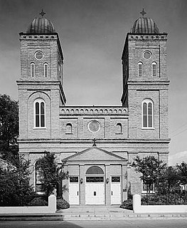
The Basilica of the Immaculate Conception is a Minor Basilica located in Natchitoches, Louisiana, United States. It is also a parish church in the Diocese of Alexandria. The church building is the seventh structure to house the parish and was at one time the cathedral for the Roman Catholic Diocese of Natchitoches. As the Church of the Immaculate Conception it was listed as contributing property in the Natchitoches Historic District on the National Register of Historic Places.
Creston is an unincorporated community in Natchitoches Parish, Louisiana, United States. Creston is not included in the 2010 United States Census.
Chestnut is an unincorporated community in Natchitoches Parish, Louisiana, United States.
Grappes Bluff is an unincorporated community in Natchitoches Parish, Louisiana, United States. It was located nearby Louisiana 480.
Monnie Tom Cheves was a college professor from, among other residences, Natchitoches, Louisiana, who served from 1952 to 1960 as a Democratic member of the Louisiana House of Representatives for Natchitoches Parish during the terms of Governors Robert F. Kennon and Earl Kemp Long.
Gorum is an unincorporated community in Natchitoches Parish, Louisiana, United States. The community is located on Louisiana Highway 119, 24 miles (39 km) south-southeast of Natchitoches. Gorum has a post office with ZIP code 71434, which opened on November 21, 1890.