
Lumber or timber is a type of wood that has been processed into beams and planks, a stage in the process of wood production. Lumber is mainly used for structural purposes but has many other uses as well.
Wood County is a county in the U.S. state of West Virginia. As of the 2010 census, the population was 86,956, making it West Virginia's fifth-most populous county. Its county seat is Parkersburg. The county was formed in 1798 from the western part of Harrison County and named for James Wood, governor of Virginia from 1796 to 1799.

Wood County is a county located in the U.S. state of Ohio. As of the 2010 census, the population was 125,488. Its county seat is Bowling Green. The county was named for Captain Eleazer D. Wood, the engineer for General William Henry Harrison's army, who built Fort Meigs in the War of 1812.

Lake of the Woods County is a county in the U.S. state of Minnesota. As of the 2010 census, the population was 4,045, making it the second-least populous county in Minnesota. Its county seat is Baudette. The county was organized on November 28, 1922, though county functions did not begin until 1923.

Woods Hole is a census-designated place in the town of Falmouth in Barnstable County, Massachusetts, United States. It lies at the extreme southwest corner of Cape Cod, near Martha's Vineyard and the Elizabeth Islands. The population was 781 at the 2010 census.
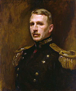
Leonard Wood was a United States Army major general, physician, and public official. He served as the Chief of Staff of the United States Army, Military Governor of Cuba, and Governor General of the Philippines. He began his military career as an army doctor on the frontier, where he received the Medal of Honor. During the Spanish–American War, he commanded the Rough Riders, with Theodore Roosevelt as his second-in-command. Wood was bypassed for a major command in World War I, but then became a prominent Republican Party leader and a leading candidate for the 1920 presidential nomination.

The Bretton Woods Conference, formally known as the United Nations Monetary and Financial Conference, was the gathering of 730 delegates from all 44 Allied nations at the Mount Washington Hotel, situated in Bretton Woods, New Hampshire, United States, to regulate the international monetary and financial order after the conclusion of World War II.

Lake of the Woods is a lake occupying parts of the Canadian provinces of Ontario and Manitoba and the U.S. state of Minnesota. It separates a small land area of Minnesota from the rest of the United States. The Northwest Angle and the town of Angle Township can be reached from the rest of Minnesota only by crossing the lake or by traveling through Canada. The Northwest Angle is the northernmost part of the contiguous United States. Its "northwesternmost point" served as a problematic landmark in treaties defining the international border.
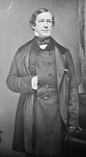
Fernando Wood was an American politician of the Democratic Party and the 73rd and 75th mayor of New York City; he also served as a United States Representative and as Chairman of the Committee on Ways and Means in both the 45th and 46th Congress (1877–1881).
The Bretton Woods system of monetary management established the rules for commercial and financial relations among the United States, Canada, Western European countries, Australia, and Japan after the 1944 Bretton Woods Agreement. The Bretton Woods system was the first example of a fully negotiated monetary order intended to govern monetary relations among independent states. The chief features of the Bretton Woods system were an obligation for each country to adopt a monetary policy that maintained its external exchange rates within 1 percent by tying its currency to gold and the ability of the IMF to bridge temporary imbalances of payments. Also, there was a need to address the lack of cooperation among other countries and to prevent competitive devaluation of the currencies as well.

The Battle of Belleau Wood occurred during the German Spring Offensive in World War I, near the Marne River in France. The battle was fought between the U.S. 2nd and 3rd Divisions along with French and British forces against an assortment of German units including elements from the 237th, 10th, 197th, 87th, and 28th Divisions. The battle has become a key component of the lore of the United States Marine Corps.

The Canada–United States border, officially known as the International Boundary, is the longest international border in the world between two countries. It is shared between Canada and the United States, the second- and fourth-largest countries by area, respectively. The terrestrial boundary is 8,891 kilometres (5,525 mi) long, of which 2,475 kilometres (1,538 mi) is Canada's border with Alaska. Eight Canadian provinces and territories, and thirteen U.S. states are located along the border.
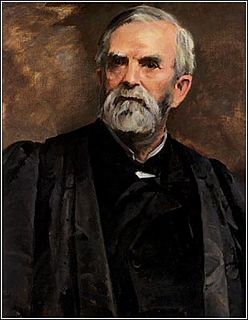
William Burnham Woods was a United States Circuit Judge and an Associate Justice of the United States Supreme Court as well as an Ohio politician and soldier in the Civil War.

Millettia laurentii is a legume tree from Africa and native to the Republic of Congo, the Democratic Republic of Congo, Cameroon, Gabon and Equatorial Guinea. The species is listed as "endangered" in the IUCN Red List, principally due to destruction of its habitat and over-exploitation for timber. Wenge, a dark colored wood, is the product of Millettia laurentii. Other names sometimes used for wenge include African rosewood (ambiguous), faux ebony, dikela, mibotu, bokonge, and awong. The wood's distinctive color is standardized as a "wenge" color in many systems.
Abiel Wood was a U.S. Representative from Massachusetts. Born in Wiscasset, Maine, he was the son of Gen. Abiel Wood (1743–1811) and Betsey Tinkham, both originally of Middleborough, Massachusetts. He was the second of eleven children. Wood attended the common schools, then engaged in mercantile pursuits. He served as member of the Massachusetts House of Representatives 1807–1811, and again in 1816.

William Robert Wood was a U.S. Representative from Indiana.
Alexander “Alec” Wood Was a former Scottish American soccer defender. Wood began his club career in the United States before moving to England in the early 1930s. He also played all three U.S. games at the 1930 FIFA World Cup. He is a member of the National Soccer Hall of Fame.
Thomas Jefferson Wood was a member of the United States House of Representatives from Indiana.
Kimba Maureen Wood is a Senior United States District Judge of the United States District Court for the Southern District of New York. Wood has presided over many high profile cases including "Junk Bond King" Michael Milken, Republican majority leader of the New York State Senate Dean Skelos, and Donald Trump's personal attorney, Michael Cohen. She is known for being low-key yet firm.

Sterling Woods is an unincorporated community located within Wall Township in Monmouth County, New Jersey, United States.


