
The Northern Territory is an Australian territory in the central and central northern regions of Australia. Northern Territory shares its borders with Western Australia to the west, South Australia to the south, and Queensland to the east. To the north, the territory looks out to the Timor Sea, the Arafura Sea and the Gulf of Carpentaria, including Western New Guinea and other islands of the Indonesian archipelago.

Dunn County is a county in the U.S. state of Wisconsin. As of the 2010 census, the population was 43,857. Its county seat is Menomonie.
Victoria is the smallest mainland state in Australia. As of 2008 it contained 2,850 separate protected areas with a total land area of 39,273 km2 (15,163 sq mi). Of these, 45 were national parks, totalling 28,023 km2 (10,820 sq mi).
A spring creek is a stream that flows from a spring.

Stuart Highway is one of Australia's major highways. It runs from Darwin, in the Northern Territory, via Tennant Creek and Alice Springs, to Port Augusta in South Australia; a distance of 2,720 km (1,690 mi). Its northern and southern extremities are segments of Australia's Highway 1. The principal north-south route through the central interior of mainland Australia, the highway is often referred to simply as "The Track".

Copley is a town in the Australian state of South Australia. At the 2006 census, Copley had a population of 104.
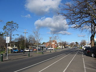
Heathcotepronunciation (help·info) is a town in central Victoria, Australia, situated on the Northern Highway 110 kilometres north of Melbourne and 40 kilometres south-east of Bendigo via the McIvor Highway. Heathcote's local government area is the City of Greater Bendigo and it is part of the federal electorate of Bendigo and the state electorate of Euroa. At the 2016 census, Heathcote had a population of 2,793.

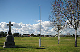
The Heathcote-Graytown National Park is a national park located in the North Central region of Victoria, Australia. The 12,833-hectare (31,710-acre) national park, which includes sections of the Great Dividing Range, adjoins a number of state forests, including the McIvor Ranges State Forest and is located just outside the town of Heathcote.

Williamstown is a small South Australian town on the southern fringe of the Barossa Valley wine-growing region. It is 51 km north east of Adelaide and 16 km south-east of Gawler. Williamstown was originally known as Victoria Creek. The township was laid out in 1858 by Lewis Johnston, or Johnstone, on land he purchased in 1857, and named for his son.

The Hutt River is a river located in the Mid North and Clare Valley regions of the Australian state of South Australia.
Rosewater is one of the western suburbs of Adelaide and is located 10 km north-west of Adelaide's central business district. Although mainly residential, there are many shops along Grand Junction Road and the closed Rosewater Loop railway line runs through the suburb. Rosewater is split in half by Grand Junction Road and bordered on the east by Addison Road, and on the south by Torrens Road.
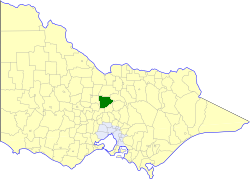
The Shire of Goulburn was a local government area about 120 kilometres (75 mi) north of Melbourne, the state capital of Victoria, Australia. The shire covered an area of 1,016 square kilometres (392.3 sq mi), and existed from 1868 until 1994.
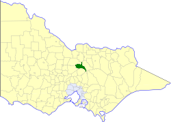
The Shire of McIvor was a local government area about 110 kilometres (68 mi) north of Melbourne, the state capital of Victoria, Australia. The shire covered an area of 1,295 square kilometres (500.0 sq mi), and existed from 1863 until 1994.
Mambray Creek is a locality in the Australian state of South Australia located on the east coast of Spencer Gulf about 240 kilometres (150 mi) north of the state capital of Adelaide and about 40 kilometres (25 mi) north of the city of Port Pirie.

Graytown is an unincorporated community located in the towns of New Haven in Dunn County and Vance Creek in Barron County, Wisconsin, United States. The community was named for Aaron B. Gray, a New Yorker who had opened a hotel in the mid-1870s.

Moses Wilson Gray, known as Wilson Gray was an Irish-born barrister, member of the Victorian Legislative Assembly and district judge in New Zealand.

Spring Creek is a locality split between the Toowoomba Region and the Southern Downs Region, Queensland, Australia.
Tilley Swamp is a locality in the Australian state of South Australia located in the state's south-east about 199 kilometres (124 mi) south-east of the state capital of Adelaide and about 55 kilometres (34 mi) north of the municipal seat of Kingston SE. The 2016 Australian census, which was conducted in August 2016, reports that the area had a population of 27 people.
Spring Creek is a rural locality in the Lockyer Valley Region, Queensland, Australia. In the 2016 census Spring Creek had a population of 601 people.
