
Stearns County is a county in the U.S. state of Minnesota. As of the 2020 census, the population was 158,292. Its county seat and largest city is St. Cloud.

Sherburne County is a county in Central Minnesota. At the 2020 census, the population was 97,183. The county seat is Elk River.

Minneapolis–Saint Paul is a metropolitan area in the Upper Midwestern United States centered around the confluence of the Mississippi, Minnesota, and St. Croix rivers in the U.S. state of Minnesota. It is commonly known as the Twin Cities after the area's two largest cities, Minneapolis and Saint Paul. Minnesotans often refer to the two together simply as "the cities". The area is Minnesota's economic, cultural, and political center.

Cold Spring is a city in Stearns County, Minnesota, United States, at the gateway of the Sauk River Chain of Lakes, an interconnected system of 14 bay-like lakes fed and connected by the Sauk River. Cold Spring is part of the St. Cloud Metropolitan Statistical Area. Its population was 4,025 at the 2010 census.

St. Cloud or Saint Cloud is a city in the U.S. state of Minnesota and the largest population center in the state's central region. The population was 68,881 at the 2020 census, making it Minnesota's 12th-largest city. St. Cloud is the county seat of Stearns County and was named after the city of Saint-Cloud, France, which was named after the 6th-century French monk Clodoald.

The New York Public Library (NYPL) is a public library system in New York City. With nearly 53 million items and 92 locations, the New York Public Library is the second-largest public library in the United States behind the Library of Congress and the fourth-largest public library in the world. It is a private, non-governmental, independently managed, nonprofit corporation operating with both private and public financing.
The Brooklyn Public Library (BPL) is the public library system of the New York City borough of Brooklyn. It is the sixteenth largest public library system in the United States by holding and the seventh by number of visitors. Like the two other public library systems in New York City, it is an independent nonprofit organization that is funded by the city and state governments, the federal government, and private donors. In marketing materials, the library styles its name as Bklyn Public Library.

The Cleveland Public Library is a public library system in Cleveland, Ohio. Founded in 1869, it had a circulation of 3.5 million items in 2020. It operates the Main Library on Superior Avenue in downtown Cleveland, 27 branches throughout the city, a mobile library, a Public Administration Library in City Hall, and the Ohio Library for the Blind and Physically Disabled. The library replaced the State Library of Ohio as the location for the Ohio Center for the Book in 2003.
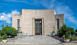
Cincinnati and Hamilton County Public Library (CHPL) is a public library system in the United States. In addition to its main library location in downtown Cincinnati, Ohio, CHPL operates 40 regional and branch locations throughout Hamilton County.

The Jacksonville Public Library is the public library system of Jacksonville, Florida, United States. It primarily serves Jacksonville and Duval County merged areas, and is also used by the neighboring Baker, Nassau, Clay, and St. Johns counties. It is one of the largest library systems in Florida, with a collection of over three million items. A division of the city government, the library has the third largest group of city employees, after the city's fire department and sheriff's office. There are twenty-one branches and a main library in the system.

Interstate 94 (I-94) in the US state of Minnesota runs 259 miles (417 km) east–west through the central portion of the state. The highway connects the cities of Moorhead, Fergus Falls, Alexandria, St. Cloud, Minneapolis, and Saint Paul. Authorized in 1956, it was mostly constructed in the 1960s. For its whole length, it runs concurrently with either US Highway 52 (US 52) or US 12.
The County of Brant Public Library is the public library system serving the communities in the County of Brant, Ontario, Canada. It has five branches located in Paris, Burford, Scotland, St. George, and Glen Morris.

The Thief River Falls Library is a library and historic site in Thief River Falls, Minnesota, USA that dates from 1900.

The El Paso Public Libraries is the municipal public library system of El Paso, Texas. The library serves the needs the public in El Paso, Texas, Chaparral, New Mexico and Ciudad Juarez, Mexico. It consists of 14 branches and one Bookmobile service. Multiple outreach services are also available including a Homebound service.
The Tampa–Hillsborough County Public Library System (THPL) is a public library system based in Hillsborough County, Florida. THPL is part of two larger library networks, the Tampa Bay Library Consortium, and the Hillsborough County Public Library Cooperative which includes Temple Terrace Public Library in Temple Terrace, Florida, and Bruton Memorial Library in Plant City, Florida. There are 33 branches of the Hillsborough County Public Library Cooperative. Services provided by the THPL include internet access, public meeting room spaces, interlibrary loans, a Bookmobile, a Cybermobile for Spanish speakers, technology classes, adult literacy programs, and downloadable eBooks. Drive-thru windows for returns and hold pick-ups are located at the Jimmie B. Keel and the Jan Kaminis Platt Regional Libraries. In 2017, THPL introduced the new HAAL Pass, which gives access to certain library resources to all students in the Hillsborough County Public Schools System. Students use their student ID number to use different online databases, borrow up to three physical items and read eBooks. The Tampa–Hillsborough County Public Library System is also a part of Hillsborough County government. On January 1, 2018, the library cooperative became one of the largest in the country to go fine free. Overdue fees for borrowed materials were eliminated with the implementation of the "Just Bring It Back" initiative. In 2019 the cooperative received the FLA Library of the Year Award. Tampa-Hillsborough County Public Library was recognized for its community focused initiatives as it "reorganized its staffing model and eliminated overdue fines, yielding $1 million in savings while increasing access to library resources and expanding opportunities for community engagement through unique, scalable programs."

The historic Duluth Public Library is a former Carnegie library building at 101 West Second Street in Duluth, Minnesota, United States. It was constructed in 1902 as the first purpose-built facility of the Duluth Public Library. It was listed on the National Register of Historic Places in 1978 for its local significance in the themes of architecture and education. It was nominated for its Neoclassical architecture and association with early community education efforts.
The Manatee County Public Library is a public library that provides services and resources to the communities and visitors of Manatee County. It is a division of the Manatee County Government's Community and Veterans Services Department located in Manatee County, Florida. The library system provides patrons with in-person resources such as books, movies, and music, as well as online databases to access e-books, e-audiobooks, journal articles, magazines, and other resources. Library services include free events for the public, one-on-one learning sessions, and computers and other technological equipment available for public use. Library cards are provided at no charge to those who reside, own property, attend school, or work in Manatee County.
The Coweta Public Library System (CPLS) is a group of four public libraries in Coweta County, Georgia, United States. The branches serve the towns of Grantville, Newnan, and Senoia.

The Chattahoochee Valley Libraries (CVL) are a consortium of public libraries serving the Greater Columbus area of Georgia, United States. The library system consists of seven branches over four counties, Muscogee, Chattahoochee, Marion, and Stewart, Georgia. The headquarters of the library system is the Columbus Public Library located in the county seat, Columbus.

The South Georgia Regional Library (SGRL) is a public library system consisting of six branches across the counties of Lowndes, Echols, and Lanier, Georgia. The headquarters library is the Valdosta-Lowndes County Library located in Valdosta, Georgia.

