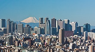
A megacity is a very large city, typically with a population of more than 10 million people. Precise definitions vary: the United Nations Department of Economic and Social Affairs in its 2018 "World Urbanization Prospects" report counted urban agglomerations having over 10 million inhabitants. A University of Bonn report held that they are "usually defined as metropolitan areas with a total population of 10 million or more people". Others list cities satisfying criteria of either 5 or 8 million and also having a population density of 2,000 per square kilometre. The terms conurbation, metropolis, and metroplex are also applied to the latter.

Accra is the capital and largest city of Ghana, located on the southern coast at the Gulf of Guinea, which is part of the Atlantic Ocean. As of 2021 census, the Accra Metropolitan District, 20.4 km2 (7.9 sq mi), had a population of 284,124 inhabitants, and the larger Greater Accra Region, 3,245 km2 (1,253 sq mi), had a population of 5,455,692 inhabitants. In common usage, the name "Accra" often refers to the territory of the Accra Metropolitan District as it existed before 2008, when it covered 199.4 km2 (77.0 sq mi). This territory has since been split into 13 local government districts: 12 independent municipal districts and the reduced Accra Metropolitan District (20.4 km2), which is the only district within the capital to be granted city status. This territory of 199.4 km2 contained 1,782,150 inhabitants at the 2021 census, and serves as the capital of Ghana, while the district under the jurisdiction of the Accra Metropolitan Assembly proper (20.4 km2) is distinguished from the rest of the capital as the "City of Accra".

A metropolitan area or metro is a region that consists of a densely populated urban agglomeration and its surrounding territories sharing industries, commercial areas, transport network, infrastructures and housing. A metro area usually comprises multiple principal cities, jurisdictions and municipalities: neighborhoods, townships, boroughs, cities, towns, exurbs, suburbs, counties, districts, as well as even states and nations like the eurodistricts. As social, economic and political institutions have changed, metropolitan areas have become key economic and political regions.

An exurb is an area outside the typically denser inner suburban area, at the edge of a metropolitan area, which has some economic and commuting connection to the metro area, low housing density, and growth. It shapes an interface between urban and rural landscapes holding a limited urban nature for its functional, economic, and social interaction with the urban center, due to its dominant residential character. They consist of "agglomerations of housing and jobs outside the municipal boundaries of a primary city" and beyond the surrounding suburbs.
A conurbation is a region comprising a number of metropolises, cities, large towns, and other urban areas which through population growth and physical expansion, have merged to form one continuous urban or industrially developed area. In most cases, a conurbation is a polycentric urbanised area in which transportation has developed to link areas. They create a single urban labour market or travel to work area.

An urban area, built-up area or urban agglomeration is a human settlement with a high population density and infrastructure of built environment. Urban areas are created through urbanization and are categorized by urban morphology as cities, towns, conurbations or suburbs. In urbanism, the term contrasts to rural areas such as villages and hamlets; in urban sociology or urban anthropology it contrasts with natural environment. The creation of earlier predecessors of urban areas during the urban revolution led to the creation of human civilization with modern urban planning, which along with other human activities such as exploitation of natural resources led to a human impact on the environment. "Agglomeration effects" are in the list of the main consequences of increased rates of firm creation since. This is due to conditions created by a greater level of industrial activity in a given region. However, a favorable environment for human capital development would also be generated simultaneously.
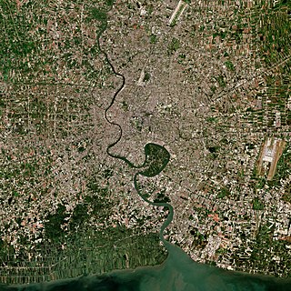
The Bangkok Metropolitan Region (BMR), may refer to a government-defined "political definition" of the urban region surrounding the metropolis of Bangkok, or the built-up area, i.e., urban agglomeration of Bangkok, Thailand, which varies in size and shape, and gets filled in as development expands.

A city proper is the geographical area contained within city limits. The term proper is not exclusive to cities; it can describe the geographical area within the boundaries of any given locality. The United Nations defines the term as "the single political jurisdiction which contains the historical city centre."

Tema is a city on the Bight of Benin and Atlantic coast of Ghana. It is located 25 kilometres (16 mi) east of the capital city; Accra, in the region of Greater Accra, and is the capital of the Tema Metropolitan District. As of 2013, Tema is the eleventh most populous settlement in Ghana, with a population of approximately 161,612 people – a marked decrease from its 2005 figure of 209,000. The Greenwich Meridian passes directly through the city. Tema is locally nicknamed the "Harbour City" because of its status as Ghana's largest seaport. It consists of 25 different communities which are numbered accordingly with each of them having easy access to the basic amenities.

The Greater Accra Region has the smallest area of Ghana's 16 administrative regions, occupying a total land surface of 3,245 square kilometres. This is 1.4 per cent of the total land area of Ghana. It is the second most populated region, before the Ashanti Region, with a population of 5,455,692 in 2021, accounting for 17.7 per cent of Ghana's total population.

The Accra Metropolitan District is one of the 254 Metropolitan, Municipal and Districts in Ghana, and among the 26 such districts in the Greater Accra Region with a population of 284,124 as of 2021. As of March 2018, it spans an area of approximately 60 km2 (23 sq mi) and encompasses the Ablekuma South, Ashiedu Keteke, and Okaikoi South sub-metropolitan district councils.

The Kochi metropolitan area or Kochi urban agglomeration is a metropolitan area centered around the city of Kochi, in Ernakulam district, Kerala, India. With a population of more than 2.1 million within an area of 440 km², it is the most populous metropolitan area in Kerala.

Urbanization in China increased in speed following the initiation of the reform and opening policy. As of 2022, China had an urbanization rate of 64.7% and was expected to reach 75-80% by 2035.

A metropolis is a large city or conurbation which is a significant economic, political, and cultural center for a country or region, and an important hub for regional or international connections, commerce, and communications.

Ablekuma South is one of the constituencies represented in the Parliament of Ghana. It elects one Member of Parliament (MP) by the first past the post system of election. Ablekuma South is located in the Accra Metropolitan Area of the Greater Accra Region of Ghana. It is one of the six sub metropolitan district councils of Accra Metropolitan Assembly.

Kasoa, formerly known as Odupongkpehe, is a peri-urban town in the Awutu Senya East Municipal District of the Central region of Ghana.
Ga West Municipal District is one of the twenty-nine districts in Greater Accra Region, Ghana. Originally it was formerly part of the then-larger Ga District in 1988, until the eastern part of the district was split off to create Ga East District in 2004; thus the remaining part has been renamed as Ga West District. Later, the western part of the district was split off to create the first Ga South Municipal District on 29 February 2008, with Weija as its capital town; while Ga West was later elevated to municipal district assembly status during that same year to become Ga West Municipal District. However on 15 March 2018, the eastern part of the district has split off to create Ga North Municipal District, thus the remaining part has been retained as Ga West Municipal District. The municipality is located in the western part of Greater Accra Region and has Amasaman as its capital town.
The following is a timeline of the history of the city of Accra, Ghana.

The Abidjan–Lagos Corridor, also known as the Abidjan–Lagos Megalopolis, is an emerging transnational megalopolis on the coast of southern West Africa. It stretches from Abidjan to Lagos, crossing five independent states from west to east, and includes two political capitals and many regional economic centers. The corridor has a length of approximately 965 kilometers. Within the megalopolis, a significant portion of West Africa's economic output is generated, and cities within the corridor are among the most economically developed of their respective countries, for which agglomeration effects and access to the Atlantic Ocean are responsible. The population within the region is experiencing rapid growth, and nearly 50 million people are expected to live within the corridor by 2035. According to projections, by the end of the 21st century, the region could become the largest urban region with continuous settlement in the world, then with up to half a billion inhabitants.
