Greenacres, Washington

Last updated
Greenacres, Washington
Locale
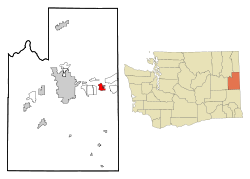
Spokane County Washington Incorporated and Unincorporated areas Green Acres Highlighted.svg
Location of the CDP of Greenacres, Washington at the 2000 Census
Coordinates: 47°39′48″N117°9′24″W / 47.66333°N 117.15667°W / 47.66333; -117.15667
CountryUnited States
State Washington
County Spokane
Area
  Total3.4 sq mi (8.7 km2)
  Land3.3 sq mi (8.6 km2)
  Water0.1 sq mi (0.1 km2)
Population
 (2000)
  Total5,158
  Density1,554.7/sq mi (600.3/km2)
Time zone UTC-8 (Pacific (PST))
  Summer (DST) UTC-7 (PDT)
ZIP code
99016
Area code 509
FIPS code 53-28520 [1]
GNIS feature ID1505280 [2]

Greenacres is a locale and former census-designated place (CDP) in Spokane County, Washington, United States. The locale is almost entirely split between the city of Spokane Valley and unincorporated Spokane County, with a small portion being located within the city of Liberty Lake. Greenacres retains its own post office. [3]

Contents

Greenacres has two schools in the Central Valley School named after it; Greenacres Middle School and Greenacres Elementary School.

History

Greenacres ca. 1910 Greenacres, Spokane County, Washington, approximately 1910 (WASTATE 1012).jpeg
Greenacres ca. 1910

Greenacres was listed as a census-designated place (CDP) in the 2000 census with the spelling "Green Acres". The community largely became part of Spokane Valley when that city incorporated in March 2003. Since then the name Greenacres has been classified as an "official common name for a populated location within an incorporated place". [2]

The majority of the CDP became part of the city of Spokane Valley upon its incorporation in 2003. An additional section of the CDP became part of the city of Liberty Lake in 2006. [4] The population was 5,158 at the 2000 census.

Geography

Greenacres is located at 47°39′48″N117°9′24″W / 47.66333°N 117.15667°W / 47.66333; -117.15667 (47.663450, -117.156537). [5]

According to the United States Census Bureau, the CDP had a total area of 3.4 square miles (8.8 km2), of which, 3.3 square miles (8.5 km2) was land and 0.1 square miles (0.26 km2) of it (1.78%) was water.

Demographics

Historical population
CensusPop.Note
1950 1,287
1960 2,07461.1%
1970 2,32412.1%
1990 4,626
2000 5,15811.5%
2007 (est.)5,618
U.S. Decennial Census [6]

6,913 population in
the 2010 Estimate
unsourced

As of the census of 2000, there were 5,158 people, 2,021 households, and 1,414 families residing in the CDP. The population density was 1,554.7 per square mile (600.3/km2). There were 2,126 housing units at an average density of 640.8 per square mile (247.4/km2). The racial makeup of the CDP was 95.17% White, 0.47% African American, 1.01% Native American, 0.72% Asian, 0.02% Pacific Islander, 0.33% from other races, and 2.29% from two or more races. Hispanic or Latino of any race were 2.46% of the population.

There were 2,021 households, out of which 33.2% had children under the age of 18 living with them, 56.2% were married couples living together, 10.3% had a female householder with no husband present, and 30.0% were non-families. 24.6% of all households were made up of individuals, and 8.8% had someone living alone who was 65 years of age or older. The average household size was 2.55 and the average family size was 3.04.

In the CDP, the age distribution of the population shows 26.8% under the age of 18, 6.5% from 18 to 24, 28.9% from 25 to 44, 24.6% from 45 to 64, and 13.1% who were 65 years of age or older. The median age was 38 years. For every 100 females, there were 97.9 males. For every 100 females age 18 and over, there were 93.6 males.

The median income for a household in the CDP was $36,290, and the median income for a family was $38,839. Males had a median income of $32,488 versus $22,361 for females. The per capita income for the CDP was $15,494. About 7.0% of families and 10.5% of the population were below the poverty line, including 14.4% of those under age 18 and 2.5% of those age 65 or over.

Related Research Articles

<span class="mw-page-title-main">Spokane County, Washington</span> County in Washington, United States

Spokane County is a county located in the U.S. state of Washington. As of the 2020 census, its population was 539,339, making it the fourth-most populous county in Washington. The largest city and county seat is Spokane, the second largest city in the state after Seattle. The county is named after the Spokane people.
<span class="mw-page-title-main">Valinda, California</span> Census-designated place in California, United States

Valinda is a census-designated place (CDP) in the San Gabriel Valley, in Los Angeles County, California, in the United States. At the 2010 census, the population was 22,822, up from 21,776 at the 2000 census.

<span class="mw-page-title-main">Prattville, California</span> Census-designated place in California, United States

Prattville is a census-designated place (CDP) in Plumas County, California, United States. The population was 24 at the 2020 census, down from 33 at the 2000 census.

Quail Valley is a former census-designated place (CDP) in Riverside County, California, United States. On October 1, 2008, the community along with the neighboring communities of Sun City and Menifee incorporated as the City of Menifee.

<span class="mw-page-title-main">Hurley, Mississippi</span> Census-designated place in Mississippi

Hurley is an unincorporated community and census-designated place (CDP) in Jackson County, Mississippi, United States. It is part of the Pascagoula Metropolitan Statistical Area. The population was 1,551 at the 2010 census, up from 985 at the 2000 census.

<span class="mw-page-title-main">Eagleville, Montgomery County, Pennsylvania</span> Census-designated place in Pennsylvania, United States

Eagleville is a census-designated place (CDP) in Montgomery County, Pennsylvania, United States. The population was 4,800 at the 2010 census. It is within Lower Providence Township.

<span class="mw-page-title-main">Banks Lake South, Washington</span> Census-designated place in Washington, United States

Banks Lake South is a census-designated place (CDP) in Grant County, Washington, United States. The population was 234 at the 2020 census.

<span class="mw-page-title-main">Ocean City, Washington</span> Census-designated place in Washington, United States

Ocean City is a census-designated place (CDP) in Grays Harbor County, Washington, United States. The population was 232 at the 2020 census, up from 200 at the 2010 census.

<span class="mw-page-title-main">Country Homes, Washington</span> CDP in Washington, United States

Country Homes is a census-designated place (CDP) in Spokane County, Washington, United States. The population was 6,251 at the 2020 census. The campus of Whitworth University is located in Country Homes. It is a largely suburban area that blends into the north side of the city of Spokane and the neighboring CDPs of Town and Country and Fairwood.

<span class="mw-page-title-main">Dishman, Washington</span> Locale in Washington, United States

Dishman is a locale and former census-designated place (CDP) in Spokane County, Washington, United States. Founded by Addison T. Dishman (II), who operated a nearby rock quarry in 1889, its population was 10,031 at the 2000 census. Dishman has been part of Spokane Valley since 2003.

<span class="mw-page-title-main">Fairwood, Spokane County, Washington</span> CDP in Washington, United States

Fairwood is a census-designated place (CDP) in Spokane County, Washington, United States. The population was 10,541 at the 2020 census.

<span class="mw-page-title-main">Latah, Washington</span> Town in Washington, United States

Latah is a town in Spokane County, Washington, United States. The population was 185 at the 2020 census. It was named for the nearby creek, Latah Creek, from the native word for fish. The town was formerly called, Hangman's Creek and Alpha.

<span class="mw-page-title-main">Liberty Lake, Washington</span> City in Washington, United States

Liberty Lake is a city in Spokane County, Washington, United States, located adjacent to the eponymous lake. Located just over a mile west of the Washington–Idaho border, Liberty Lake is both a suburb of Spokane, Washington and a bedroom community to Coeur d'Alene, Idaho. The population was 12,003 at the 2020 census.

<span class="mw-page-title-main">Millwood, Washington</span> City in Washington, United States

Millwood is a city in Spokane County, Washington, United States. The population was 1,786 at the 2010 census. Millwood is a suburb of Spokane, and is surrounded on three sides by the city of Spokane Valley. The Spokane River flows along the northern edge of the city. The city is home to the National Register of Historic Places listed Millwood Historic District.

<span class="mw-page-title-main">Opportunity, Washington</span> Locale in Washington, United States

Opportunity is a locale and former census-designated place in Spokane County, Washington, United States. The population was 25,065 at the 2000 census.
<span class="mw-page-title-main">Otis Orchards-East Farms, Washington</span> CDP in Washington, United States

Otis Orchards-East Farms is a census-designated place (CDP) in Spokane County, Washington, United States, near the county's border with Idaho. The population was 6,299 at the 2020 census. The CDP includes the unincorporated communities of Otis Orchards and East Farms. Otis Orchards contains the bulk of the businesses of the community.

<span class="mw-page-title-main">Spangle, Washington</span> City in Washington, United States

Spangle is a city in Spokane County, Washington, United States. The population was 278 at the 2010 census. The name comes from William Spangle, an early pioneer.
<span class="mw-page-title-main">Trentwood, Washington</span> Locale in Washington, United States

Trentwood is a locale and former census-designated place (CDP) in Spokane County, Washington, United States, east across the Spokane River from Irwin. The population was 4,388 at the 2000 census. Trentwood joined the other unincorporated communities in the region to form the city of Spokane Valley in 2003.

<span class="mw-page-title-main">Veradale, Washington</span> Locale in Washington, United States

Veradale—originally known as Vera—is a locale and former census-designated place in Spokane County, Washington, United States. The population was 9,387 at the 2000 census. Veradale retains its own post office.

<span class="mw-page-title-main">Bethlehem Village, Connecticut</span> Census-designated place in Connecticut, United States

Bethlehem Village is a census-designated place (CDP) within the town of Bethlehem in Litchfield County, Connecticut, United States. The CDP includes the Bethlehem Green Historic District at the town center, as well as surrounding residential and rural land. As of the 2010 census, the CDP had a population of 2,021, out of a population of 3,607 for the entire town of Bethlehem.
References

  1. "U.S. Census website". United States Census Bureau . Retrieved January 31, 2008.
  2. 1 2 U.S. Geological Survey Geographic Names Information System: Greenacres, Washington
  3. "Greenacres". United States Postal Service . Retrieved June 6, 2019.
  4. "Liberty Lake gets 644 acres". Spokesman Review . Retrieved December 3, 2018.
  5. "US Gazetteer files: 2010, 2000, and 1990". United States Census Bureau. February 12, 2011. Retrieved April 23, 2011.
  6. United States Census Bureau. "Census of Population and Housing" . Retrieved August 3, 2013.