This article needs additional citations for verification .(December 2018) |
Greytown | |
|---|---|
 Greytown  Greytown | |
| Coordinates: 29°04′S30°35′E / 29.067°S 30.583°E | |
| Country | South Africa |
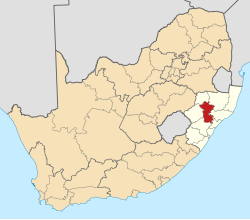
| Province | KwaZulu-Natal |
| District | Umzinyathi |
| Municipality | Umvoti |
| Established | 1854 [1] |
| Area | |
• Total | 4.75 km2 (1.83 sq mi) |
| Population (2011) [2] | |
• Total | 9,090 |
| • Density | 1,910/km2 (4,960/sq mi) |
| Racial makeup (2011) | |
| • Black African | 60.1% |
| • Coloured | 5.5% |
| • Indian/Asian | 22.3% |
| • White | 11.2% |
| • Other | 1.0% |
| First languages (2011) | |
| • Zulu | 53.1% |
| • English | 36.9% |
| • Afrikaans | 5.2% |
| • Other | 4.8% |
| Time zone | UTC+2 (SAST) |
| Postal code (street) | 3250 |
| PO box | 3250 |
| Area code | 033 |
| Website | www.greytown.co.za |
Wikimedia Commons has media related to Greytown, KwaZulu-Natal .
Greytown is a town situated on the banks of a tributary of the uMvoti River in a richly fertile timber-producing area of KwaZulu-Natal, South Africa.