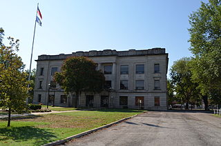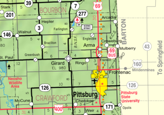
Crawford County is a county located in Southeast Kansas. Its county seat is Girard, and its most populous city is Pittsburg. As of the 2020 census, the county population was 38,972. The county was named in honor of Samuel Crawford, the 3rd governor of Kansas. Pittsburg State University is located in Crawford County.

Beulah is an unincorporated community in Crawford County, Kansas, United States.

Greenbush is an unincorporated community in Crawford County, Kansas, United States. It is located 6.5 miles (10.5 km) west of Girard along K-47 highway.
Brazilton is an unincorporated community in Crawford County, Kansas, United States. It located along highway K-3.

Opolis is an unincorporated community in Crawford County, Kansas, United States. As of the 2020 census, the population of the community and nearby areas was 104.

Englevale is an unincorporated community in Lincoln Township, Crawford County, Kansas, United States.

Farlington is an unincorporated community in Crawford County, Kansas, United States. As of the 2020 census, the population of the community and nearby areas was 68. Farlington is located near K-7, 8 miles (13 km) north of Girard.

Franklin is an unincorporated community in Crawford County, Kansas, United States. As of the 2020 census, the population of the community and nearby areas was 473. Franklin is located along U.S. Route 69, 1 mile (1.6 km) south of Arma, or 5.9 miles (9.5 km) north of Frontenac.
Curranville is an unincorporated community in Crawford County, Kansas, United States.

Croweburg is an unincorporated community in Crawford County, Kansas, United States. As of the 2020 census, the population of the community and nearby areas was 92.

Monmouth is an unincorporated community in Crawford County, Kansas, United States.

Radley is an unincorporated community in Crawford County, Kansas, United States. As of the 2020 census, the population of the community and nearby areas was 105.

Ringo is an unincorporated community in Crawford County, Kansas, United States. As of the 2020 census, the population of the community and nearby areas was 111.

Yale is an unincorporated community in Crawford County, Kansas, United States. As of the 2020 census, the population of the community and nearby areas was 81. It is located northeast of Frontenac at the intersection of E 600th Ave and S 250th St, about 1 miles west of the Missouri state border. The community is home to the Chicken Mary's and Chicken Annie's restaurants.
Cato is an unincorporated community in Crawford County, Kansas, United States.
Midway is an unincorporated community in Crawford County, Kansas, United States.
Fuller is an unincorporated community in Crawford County, Kansas, United States.
Kniveton is an unincorporated community in Cherokee and Crawford counties of Kansas in the United States.
Litchfield is an unincorporated community in Crawford County, Kansas, United States. It is located east of Frontenac at S 250th St and E 570th Ave.
Lone Oak is an unincorporated community in Crawford County, Kansas, United States.


