Arcadia, Kansas | |
---|---|
Coordinates: 37°38′28″N94°37′26″W / 37.64111°N 94.62389°W [1] | |
Country | United States |
State | Kansas |
County | Crawford |
Founded | 1862 |
Named for | Arcadia, Greece |
Area | |
• Total | 0.43 sq mi (1.13 km2) |
• Land | 0.43 sq mi (1.13 km2) |
• Water | 0.00 sq mi (0.00 km2) |
Elevation | 824 ft (251 m) |
Population | |
• Total | 254 |
• Density | 590/sq mi (220/km2) |
Time zone | UTC-6 (CST) |
• Summer (DST) | UTC-5 (CDT) |
ZIP code | 66711 |
Area code | 620 |
FIPS code | 20-02175 |
GNIS ID | 2393974 [1] |
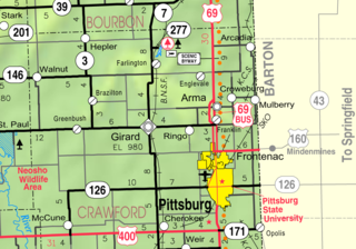
Arcadia is a city in northeast Crawford County, Kansas, United States. [1] As of the 2020 census, the population of the city was 254. [3]
Arcadia was founded in 1862. [4] It was named for the ancient region of Arcadia, in Greece. [5]
The first post office in Arcadia was established in June, 1867. [6]
Arcadia was a station on the St. Louis–San Francisco Railway. [7]
The east edge of Arcadia is the Kansas-Missouri state border.
According to the United States Census Bureau, the city has a total area of 0.44 square miles (1.14 km2), all of it land. [8]
Census | Pop. | Note | %± |
---|---|---|---|
1890 | 518 | — | |
1900 | 538 | 3.9% | |
1910 | 694 | 29.0% | |
1920 | 1,175 | 69.3% | |
1930 | 925 | −21.3% | |
1940 | 843 | −8.9% | |
1950 | 572 | −32.1% | |
1960 | 507 | −11.4% | |
1970 | 388 | −23.5% | |
1980 | 460 | 18.6% | |
1990 | 338 | −26.5% | |
2000 | 391 | 15.7% | |
2010 | 310 | −20.7% | |
2020 | 254 | −18.1% | |
U.S. Decennial Census |
The 2020 United States census counted 254 people, 128 households, and 69 families in Arcadia. [9] [10] The population density was 585.3 per square mile (226.0/km2). There were 152 housing units at an average density of 350.2 per square mile (135.2/km2). [10] [11] The racial makeup was 93.31% (237) white or European American (92.91% non-Hispanic white), 0.0% (0) black or African-American, 0.39% (1) Native American or Alaska Native, 0.0% (0) Asian, 0.0% (0) Pacific Islander or Native Hawaiian, 1.18% (3) from other races, and 5.12% (13) from two or more races. [12] Hispanic or Latino of any race was 1.97% (5) of the population. [13]
Of the 128 households, 21.1% had children under the age of 18; 32.8% were married couples living together; 27.3% had a female householder with no spouse or partner present. 45.3% of households consisted of individuals and 18.0% had someone living alone who was 65 years of age or older. [10] The average household size was 2.3 and the average family size was 2.6. [14] The percent of those with a bachelor’s degree or higher was estimated to be 9.1% of the population. [15]
22.4% of the population was under the age of 18, 4.7% from 18 to 24, 22.0% from 25 to 44, 28.7% from 45 to 64, and 22.0% who were 65 years of age or older. The median age was 45.5 years. For every 100 females, there were 89.6 males. [10] For every 100 females ages 18 and older, there were 93.1 males. [10]
The 2016-2020 5-year American Community Survey estimates show that the median household income was $36,406 (with a margin of error of +/- $26,850) and the median family income was $46,047 (+/- $6,173). [16] The median income for those above 16 years old was $35,000 (+/- $17,805). [17] Approximately, 23.6% of families and 37.2% of the population were below the poverty line, including 36.3% of those under the age of 18 and 32.0% of those ages 65 or over. [18] [19]
As of the census [20] of 2010, there were 310 people, 136 households, and 79 families living in the city. The population density was 704.5 inhabitants per square mile (272.0/km2). There were 168 housing units at an average density of 381.8 per square mile (147.4/km2). The racial makeup of the city was 91.9% White, 1.3% African American, 1.0% Native American, 1.6% from other races, and 4.2% from two or more races. Hispanic or Latino of any race were 3.2% of the population.
There were 136 households, of which 30.9% had children under the age of 18 living with them, 40.4% were married couples living together, 13.2% had a female householder with no husband present, 4.4% had a male householder with no wife present, and 41.9% were non-families. 34.6% of all households were made up of individuals, and 10.3% had someone living alone who was 65 years of age or older. The average household size was 2.28 and the average family size was 2.95.
The median age in the city was 42.2 years. 24.8% of residents were under the age of 18; 6.1% were between the ages of 18 and 24; 23.5% were from 25 to 44; 31.3% were from 45 to 64; and 14.2% were 65 years of age or older. The gender makeup of the city was 50.3% male and 49.7% female.
As of the census [21] of 2000, there were 391 people, 156 households, and 105 families living in the city. The population density was 884.0 inhabitants per square mile (341.3/km2). There were 179 housing units at an average density of 404.7 per square mile (156.3/km2). The racial makeup of the city was 96.16% White, 0.51% African American, 1.28% Native American, 1.02% from other races, and 1.02% from two or more races. Hispanic or Latino of any race were 0.26% of the population.
There were 156 households, out of which 35.9% had children under the age of 18 living with them, 45.5% were married couples living together, 15.4% had a female householder with no husband present, and 32.1% were non-families. 28.2% of all households were made up of individuals, and 13.5% had someone living alone who was 65 years of age or older. The average household size was 2.51 and the average family size was 3.08.
In the city, the population was spread out, with 27.9% under the age of 18, 11.0% from 18 to 24, 27.1% from 25 to 44, 20.7% from 45 to 64, and 13.3% who were 65 years of age or older. The median age was 34 years. For every 100 females, there were 91.7 males. For every 100 females age 18 and over, there were 95.8 males.
The median income for a household in the city was $21,750, and the median income for a family was $27,386. Males had a median income of $22,500 versus $17,321 for females. The per capita income for the city was $10,674. About 17.2% of families and 24.2% of the population were below the poverty line, including 31.2% of those under age 18 and 11.5% of those age 65 or over.
Burlington is a city in and the county seat of Coffey County, Kansas, United States. As of the 2020 census, the population of the city was 2,634.
Jennings is a city in Decatur County, Kansas, United States. As of the 2020 census, the population of the city was 81.
Quinter is a city in Gove County, Kansas, United States. As of the 2020 census, the population of the city was 929.
Hamilton is a city in Greenwood County, Kansas, United States. As of the 2020 census, the population of the city was 182.
Formoso is a city in Jewell County, Kansas, United States. As of the 2020 census, the population of the city was 94.
Fairway is a city in Johnson County, Kansas, United States. It is included in the Kansas City metropolitan area census designation and the Shawnee Mission postal services designation. As of the 2020 United States census, the city population was 4,170.
Merriam is a city in Johnson County, Kansas, United States, and part of the Kansas City Metropolitan Area. As of the 2020 census, the population of the city was 11,098. Merriam is included in the Shawnee Mission postal designation. It is also the headquarters of Seaboard Corporation.
Cunningham is a city in Kingman County, Kansas, United States. As of the 2020 census, the population of the city was 444. The city was named in honor of J.D. Cunningham, a pioneer settler.
Lansing is a city in Leavenworth County, Kansas, United States. It is situated along the west side of the Missouri River and Kansas-Missouri state border. As of the 2020 census, the population of the city was 11,239. It is the second most populous city of Leavenworth County and is a part of the Kansas City metropolitan area. The Lansing Correctional Facility, which includes the state's main maximum-security prison, is located in Lansing.
Barnard is a city in Lincoln County, Kansas, United States. As of the 2020 census, the population of the city was 64.
Americus is a city in Lyon County, Kansas, United States. As of the 2020 census, the population of the city was 776. It is located northwest of the city of Emporia. Americus is often a waypoint in some Unbound Gravel bike races.
Oketo is a city in Marshall County, Kansas, United States. As of the 2020 census, the population of the city was 64.
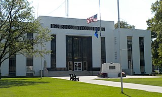
Meade is a city in and the county seat of Meade County, Kansas, United States. As of the 2020 census, the population of the city was 1,505.
Lyndon is a city in, and the county seat of Osage County, Kansas, United States. As of the 2020 census, the population of the city was 1,037.
Prairie View is a city in Phillips County, Kansas, United States. As of the 2020 census, the population of the city was 106.
Onaga is a city in Pottawatomie County, Kansas, United States. As of the 2020 census, the population of the city was 679.
Liebenthal is a city in Rush County, Kansas, United States. As of the 2020 census, the population of the city was 92. It is located 8 miles north of La Crosse.
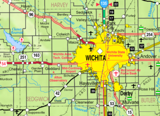
Clearwater is a city in Sedgwick County, Kansas, United States. As of the 2020 census, the population of the city was 2,653.
Linn is a city in Washington County, Kansas, United States. As of the 2020 census, the population of the city was 387.
Leoti is a city in and the county seat of Wichita County, Kansas, United States. As of the 2020 census, the population of the city was 1,475.