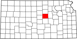
Saline County is located in the U.S. state of Kansas. Its county seat and largest city is Salina. As of the 2020 census, the county population was 54,303. The county was named after the Saline River.

Rice County is a county located in the U.S. state of Kansas. Its county seat and largest city is Lyons. As of the 2020 census, the county population was 9,427. The county was named in memory of Samuel Allen Rice, Brigadier-General, United States volunteers, killed April 30, 1864 at Jenkins Ferry, Arkansas.

Pottawatomie County is a county located in the U.S. state of Kansas. Its county seat is Westmoreland. As of the 2020 census, the county population was 25,348. The county was named for the Potawatomi tribe.

Neosho County is a county located in Southeast Kansas. Its county seat is Erie. As of the 2020 census, the county population was 15,904. The county was named for the Neosho River, which passes through the county.

Leavenworth County is located in the U.S. state of Kansas and is part of the Kansas City metropolitan area. Its county seat and most populous city is Leavenworth. As of the 2020 census, the county population was 81,881. The county was named after Henry Leavenworth, a general in the Indian Wars who established Fort Leavenworth.

Labette County is a county located in Southeast Kansas. Its county seat is Oswego, and its most populous city is Parsons. As of the 2020 census, the county population was 20,184. The county was named after LaBette creek, the second-largest creek in the county, which runs roughly NNW-SSE from near Parsons to Chetopa. The creek in turn was named after French-Canadian fur trapper Pierre LaBette who had moved to the area, living along the Neosho River, and marrying into the Osage tribe in the 1830s and 1840s.
Crawford County is a county located in Southeast Kansas. Its county seat is Girard, and its most populous city is Pittsburg. As of the 2020 census, the county population was 38,972. The county was named in honor of Samuel Crawford, the 3rd governor of Kansas. Pittsburg State University is located in Crawford County.

Brown County is a county located in the northeast portion of the U.S. state of Kansas. Its county seat and most populous city is Hiawatha. As of the 2020 census, the county population was 9,508. The county was named after Albert G. Brown, a U.S. Senator from Mississippi and Kansas statehood advocate. The Kickapoo Indian Reservation of Kansas, the majority of the Sac and Fox Reservation, and the majority of the Iowa Reservation of Kansas and Nebraska are located within the county.

Arma is a city in Crawford County, Kansas, United States. As of the 2020 census, the population of the city was 1,407.
Cherokee is a city in Crawford County, Kansas, United States. As of the 2020 census, the population of the city was 590.
Frontenac is the second largest city in Crawford County, Kansas, United States. As of the 2020 census, the population of the city was 3,382.
Girard is a city in and the county seat of Crawford County, Kansas, United States. As of the 2020 census, the population of the city was 2,496.
Mulberry is a city in Crawford County, Kansas, United States. As of the 2020 census, the population of the city was 409.

Brownell is a city in Ness County, Kansas, United States. As of the 2020 census, the population of the city was 23.
Greenbush is an unincorporated community in Crawford County, Kansas, United States. It is located 6.5 miles (10.5 km) west of Girard along K-47 highway.
Opolis is an unincorporated community in Crawford County, Kansas, United States. As of the 2020 census, the population of the community and nearby areas was 104.

Jefferson West USD 340 is a public unified school district headquartered in Meriden, Kansas, United States. It serves the communities of Meriden, Ozawkie, Rock Creek, housing along the west side of Perry Lake, and rural areas. It covers 68 square miles (180 km2) in parts of three counties in the northeastern part of Kansas.
Franklin is an unincorporated community in Crawford County, Kansas, United States. As of the 2020 census, the population of the community and nearby areas was 473. Franklin is located along U.S. Route 69, 1 mile (1.6 km) south of Arma, or 5.9 miles (9.5 km) north of Frontenac.

Weskan is an unincorporated community in Wallace County, Kansas, United States. As of the 2020 census, the population of the community and nearby areas was 158. It is located along U.S. Route 40, 11.5 miles (18.5 km) west-southwest of Sharon Springs. It is the closest community to Mount Sunflower, the highest point in Kanas.

Mount Vernon is an unincorporated community in Kingman County, Kansas, United States. It is located near the southwest side of the Cheney Reservoir dam.


