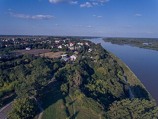
Tarnobrzeg is a city in south-eastern Poland, on the east bank of the river Vistula, with 49,419 inhabitants, as of 31 December 2009. Situated in the Subcarpathian Voivodeship since 1999, it had previously been the capital of Tarnobrzeg Voivodeship (1975–1998). Tarnobrzeg lies in the Sandomierz Basin, and directly borders the town of Sandomierz, Świętokrzyskie Voivodeship. Its history dates back to the year 1593, when it was granted Magdeburg rights, and belonged to the Tarnowski family. For centuries Tarnobrzeg remained a small town, which did not develop until the post-World War II period, when it became center of an industrial area, based on rich sulfur deposits.

Olkusz is a town in southern Poland with 36,607 inhabitants (2014). Situated in the Lesser Poland Voivodeship, previously in Katowice Voivodeship (1975–1998), it is the capital of Olkusz County. Olkusz is known for its abundance of silver, which is mined and extracted in the vicinity.

Łosice is a town in eastern Poland, seat of the Łosice County and Gmina Łosice (commune) in the Masovian Voivodeship.

Jasło is a county town in south-eastern Poland with 36,641 inhabitants, as of 31 December 2012. It is situated in the Subcarpathian Voivodeship, and it was previously part of Krosno Voivodeship (1975–1998). It is located in Lesser Poland, in the heartland of the Doły (Pits), and its average altitude is 320 metres above sea level, although there are some hills located within the confines of the city. The Patron Saint of the city is Saint Anthony of Padua.

Ropczyce is a town in the Subcarpathian Voivodeship in south-eastern Poland, situated in the valley of the Wielopolka River. The town has a population of 15,098. and is the seat of Ropczyce-Sędziszów County.
Wyszogród is a town in central Poland, in Masovian Voivodeship, in Płock County, by the Vistula River. The population of Wyszogród was 2,793 in 2004.
Nowotaniec is a village in south-eastern Poland, inhabited by about 430 (2002), in the Pogórze Bukowskie mountains. Situated in the Subcarpathian Voivodeship, previously in the Krosno Voivodeship (1975–1998) and the Sanok district, Bukowsko subdistrict, located near the towns of Medzilaborce and Palota.

Rymanów is a town located in the Subcarpathian Voivodeship, in the southeastern tip of Poland, with 3,585 inhabitants. It is a capital of a separate commune within Krosno County. Rymanów is situated in the heartland of the Doły (Pits) valley, and its average altitude is 420 metres (1,377.95 ft) above sea level, although there are some hills located within the confines of the town.
Krynkipronounced[ˈkrɨŋkʲi] is a town in northeastern Poland, located in Podlaskie Voivodeship along the border with Belarus. It lies approximately 24 kilometres (15 mi) south-east of Sokółka and about 45 km (28 mi) east of the regional capital Białystok.

Wojnicz is an ancient historic town in Tarnów County, Lesser Poland Voivodeship. In the early medieval period of the Polish state, it became one of the most important centres in the province of Lesser Poland, as part of the system of Dunajec river castles. It became the seat of a Castellan and prospered from the 13th century to the first half of the 17th century, being on an international trade route bordering Hungary and the Ottoman Empire. It had town and market rights, its church was raised to collegiate status with links to the Jagiellonian University in Kraków 64 km away.

Mszana Dolna is a town in Limanowa County, Lesser Poland Voivodeship, Poland, with 7,431 inhabitants (2004). Mszana Dolna lies among the hills of western Beskids, 50 kilometres south of Kraków. The town is located in a deep valley, surrounded by several ranges, including the Gorce Mountains featuring Gorce National Park. Mszana is located along National Road Nr. 28, which goes west–east, from Zator to Przemyśl. In 2002, the area of Mszana Dolna was 27.1 square kilometres (10.5 sq mi), out of which forests covered 50%, and arable land 36%.

Zakliczyn is a town in Tarnów County, Lesser Poland Voivodeship, Poland, with a population of 1,541 (2010). Zakliczyn lies on the right bank of the Dunajec river, surrounded by wooded hills 300 to 500 metres above sea level. Zakliczyn has a town hall, located in a spacious market square, one of the largest in the province, at 100 by 170 metres. The town was originally called Opatkowice. Its name was changed in 1558, in honour of the village of Zakliczyn, Myślenice County, which was ancient seat of the Jordan family.

Chęciny is a town in Kielce County, Świętokrzyskie Voivodeship, southern Poland, with 4,361 inhabitants as of December 2021. It was first mentioned in historical documents from 1275, and obtained its city charter in 1325. At that time was one of major urban centers of northern Lesser Poland.

Przytyk is a town in Radom County, Masovian Voivodeship, in east-central Poland, founded in the year 1333. It is the seat of the gmina called Gmina Przytyk. It lies in historic Lesser Poland, approximately 20 kilometres (12 mi) west of Radom and 84 km (52 mi) south of Warsaw. In 2006 the village had a population of 990. For centuries Przytyk belonged to Sandomierz Voivodeship, and used to be a town from 1333 to 1869.

Jaśliska is a village in Krosno County, Subcarpathian Voivodeship, in south-eastern Poland, close to the border with Slovakia. It lies approximately 16 kilometres (10 mi) south-east of Dukla, 27 km (17 mi) south of Krosno, and 67 km (42 mi) south of the regional capital Rzeszów.

Nowe Brzesko is a town in Proszowice County, Lesser Poland Voivodeship, in southern Poland. It is the seat of the gmina called Gmina Nowe Brzesko. It lies approximately 10 kilometres (6 mi) south-east of Proszowice and 33 km (21 mi) east of the regional capital Kraków. According to 2011 official census Nowe Brzesko has population of 1662. It gained town rights in 1279, but lost that status in 1870 by decree of the Russian tsar. It became a town again on 1 January 2011.

Brzostek is a town in Dębica County, Subcarpathian Voivodeship, south-eastern Poland. It is the seat of the gmina called Gmina Brzostek. As of December 2021, the town has a population of 2,760. It lies on the Wisłoka river, in the foothills of the Carpathians, approximately 19 kilometres (12 mi) south of Dębica and 46 km (29 mi) west of the regional capital Rzeszów. Brzostek is a local center of education and commerce.

Wielopole Skrzyńskie Yiddish: וילופולה, romanized: Vyelipol)is a village in Ropczyce-Sędziszów County, Subcarpathian Voivodeship, in south-eastern Poland. It is the seat of the gmina called Gmina Wielopole Skrzyńskie. It lies in historic Lesser Poland, approximately 16 kilometres (10 mi) south of Ropczyce and 30 km (19 mi) west of the regional capital Rzeszów.

Olsztyn is a town in Częstochowa County, Silesian Voivodeship, in southern Poland. It is the seat of the gmina called Gmina Olsztyn. It lies in historic Lesser Poland, approximately 12 kilometres (7 mi) south-east of Częstochowa and 59 km (37 mi) north of the voivodeship capital Katowice. The village has a population of 2,331. It contains the ruins of a 14th-century castle, which was located on a hill above the village.

Przyrów is a town in Częstochowa County, Silesian Voivodeship, in southern Poland. It is the seat of the gmina called Gmina Przyrów. It lies approximately 29 kilometres (18 mi) east of Częstochowa and 72 km (45 mi) north-east of the regional capital Katowice. Przyrów is part of historic province of Lesser Poland.