
Bozhurishte is a town in western Bulgaria. It is the administrative center of Bozhurishte Municipality in Sofia Province; close to Kostinbrod and the capital Sofia. The old airport of Sofia, now a military one, is near the town. Bozhurishte was first mentioned in 1750. Its name is derived from the flower peony.
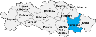
Rohožník is a small village and municipality in Humenné District in the Prešov Region of north-east Slovakia.

Allen's Grove is an unincorporated community in Walworth County, Wisconsin, United States. It is located approximately two miles west of Darien, Wisconsin, in the Towns of Darien and Sharon, Wisconsin, at 42°34′49″N88°45′45″W.

Shamakhyan is a former village in Armenia, currently absorbed by the town of Dilijan in the Tavush Province. It was not listed in the 2011 official Armenian Census, and is likely included in the census count of the town of Dilijan.
Rudnia is a village in the administrative district of Gmina Michałowo, within Białystok County, Podlaskie Voivodeship, in north-eastern Poland, close to the border with Belarus.

Stara Chmielówka is a village in the administrative district of Gmina Bakałarzewo, within Suwałki County, Podlaskie Voivodeship, in north-eastern Poland. It lies approximately 10 kilometres (6 mi) north-east of Bakałarzewo, 13 km (8 mi) north-west of Suwałki, and 116 km (72 mi) north of the regional capital Białystok.
Łapiguz is a village in the administrative district of Gmina Zamość, within Zamość County, Lublin Voivodeship, in eastern Poland. It lies approximately 5 kilometres (3 mi) north of Zamość and 74 km (46 mi) south-east of the regional capital Lublin.
Gojców is a village in the administrative district of Gmina Opatów, within Opatów County, Świętokrzyskie Voivodeship, in south-central Poland. It lies approximately 6 kilometres (4 mi) south of Opatów and 58 km (36 mi) east of the regional capital Kielce.
Tadeuszów is a village in the administrative district of Gmina Tarłów, within Opatów County, Świętokrzyskie Voivodeship, in south-central Poland. It lies approximately 7 kilometres (4 mi) south-east of Tarłów, 29 km (18 mi) north-east of Opatów, and 81 km (50 mi) east of the regional capital Kielce.
Ostrówek is a village in the administrative district of Gmina Radomyśl nad Sanem, within Stalowa Wola County, Podkarpackie Voivodeship, in south-eastern Poland.

Xinzao Station is a station of Line 4 of the Guangzhou Metro. It started operations on 26 December 2005. It is located at the underground of Zengbian Village (曾边村), Xinzao Town (新造镇), Panyu District. It was the terminus of Line 4 before the route between Xinzao and Huangge started in service on 30 December 2006.
Nowe Żabno is a village in the administrative district of Gmina Nowa Sól, within Nowa Sól County, Lubusz Voivodeship, in western Poland. It lies approximately 5 kilometres (3 mi) south of Nowa Sól and 25 km (16 mi) south-east of Zielona Góra.
Kłanino is a village in the administrative district of Gmina Krokowa, within Puck County, Pomeranian Voivodeship, in northern Poland. It lies approximately 6 kilometres (4 mi) east of Krokowa, 13 km (8 mi) north-west of Puck, and 51 km (32 mi) north-west of the regional capital Gdańsk.
Kursztyn is a village in the administrative district of Gmina Gniew, within Tczew County, Pomeranian Voivodeship, in northern Poland. It lies approximately 7 kilometres (4 mi) north-west of Gniew, 25 km (16 mi) south of Tczew, and 55 km (34 mi) south of the regional capital Gdańsk.
Surzyki Wielkie is a village in the administrative district of Gmina Małdyty, within Ostróda County, Warmian-Masurian Voivodeship, in northern Poland. It lies approximately 11 kilometres (7 mi) south of Małdyty, 20 km (12 mi) north-west of Ostróda, and 49 km (30 mi) west of the regional capital Olsztyn.

Rasos de Peguera is a ski resort located near Berga, in Catalonia(Spain), currently out of service.

Gornja Konjuša is a village in the municipality of Prokuplje, Serbia. According to the 2002 census, the village has a population of 66 people.
Molviano is a frazione in the Province of Teramo in the Abruzzo region of Italy.
Blato is a village on the island of Mljet in southern Croatia.

Borovac is a village in the municipality of Sokolac, Bosnia and Herzegovina.


