
Unzué is a town and municipality located in the province of Navarre, in the autonomous community of Navarre, in the North of Spain.

Kareli is a district of Georgia, in the region of Shida Kartli. Some northern territories of the district are part of the self-proclaimed republic of South Ossetia and have not been under control of the Georgian government since 1992.
Stropkov District is a district in the Prešov Region of eastern Slovakia. Until 1918, the district was mostly part of the county of Kingdom of Hungary of Zemplín, apart from an area in the north west around Duplín, Tisinec, Krušinec, Výškovce, Vislava, Oľšavka, Gribov and Kožuchovce which formed part of the county of Šariš.
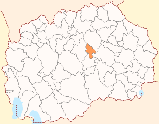
Lozovo is a municipality in eastern Republic of North Macedonia. Lozovo is also the name of the village where the municipal seat is found. Lozovo Municipality is part of the Vardar Statistical Region.
Krasyliv is a city in Khmelnytskyi Oblast (province) of western Ukraine. Krasyliv is also the administrative center of the Krasyliv Raion (district), housing the district's local administration buildings. It is located at around 49°39′7″N26°58′14″E.

The Tayandu or Tayando Islands are a group of low-lying islands just west of the larger Kai Islands of Maluku, Indonesia. The main group consists of Tayando, Walir, Heniar and several smaller isle-lets. Between Walir and Taam is Pulau Nusreen featuring a large sandy lagoon. Manggur is further west with Kur and Kaimeer islands north of it. Administratively they comprise a district (kecamatan) within the city of Tual.

Przymuszewo is a village in the administrative district of Gmina Kęsowo, within Tuchola County, Kuyavian-Pomeranian Voivodeship, in north-central Poland. It lies approximately 5 kilometres (3 mi) west of Kęsowo, 15 km (9 mi) south-west of Tuchola, and 53 km (33 mi) north-west of Bydgoszcz.
Ciechanowczyk is a village in the administrative district of Gmina Ciechanowiec, within Wysokie Mazowieckie County, Podlaskie Voivodeship, in north-eastern Poland. It lies approximately 4 kilometres (2 mi) south-east of Ciechanowiec, 30 km (19 mi) south of Wysokie Mazowieckie, and 68 km (42 mi) south-west of the regional capital Białystok.

Qarıkaha is a village in the Lachin Rayon of Azerbaijan.
Sirik is a village in the Jabrayil Rayon of Azerbaijan.
Kurów is a village in the administrative district of Gmina Chełmiec, within Nowy Sącz County, Lesser Poland Voivodeship, in southern Poland. It lies approximately 7 kilometres (4 mi) north of Chełmiec, 8 km (5 mi) north-west of Nowy Sącz, and 67 km (42 mi) south-east of the regional capital Kraków.
Przybysławice is a village in the administrative district of Gmina Klimontów, within Sandomierz County, Świętokrzyskie Voivodeship, in south-central Poland. It lies approximately 3 kilometres (2 mi) east of Klimontów, 19 km (12 mi) west of Sandomierz, and 67 km (42 mi) south-east of the regional capital Kielce.
Brzozowo-Maje is a village in the administrative district of Gmina Dzierzgowo, within Mława County, Masovian Voivodeship, in east-central Poland.
Rydzyn Włościański is a village in the administrative district of Gmina Strzegowo, within Mława County, Masovian Voivodeship, in east-central Poland.
Zalesie is a village in the administrative district of Gmina Ostrów Mazowiecka, within Ostrów Mazowiecka County, Masovian Voivodeship, in east-central Poland. It lies approximately 13 kilometres (8 mi) north-west of Ostrów Mazowiecka and 94 km (58 mi) north-east of Warsaw.
Zwierzyniec is a village in the administrative district of Gmina Międzychód, within Międzychód County, Greater Poland Voivodeship, in west-central Poland. It lies approximately 7 kilometres (4 mi) north-east of Międzychód and 73 km (45 mi) north-west of the regional capital Poznań.
Chrzanowo is a village in the administrative district of Gmina Łęczyce, within Wejherowo County, Pomeranian Voivodeship, in northern Poland. It lies approximately 8 kilometres (5 mi) north of Łęczyce, 25 km (16 mi) west of Wejherowo, and 58 km (36 mi) north-west of the regional capital Gdańsk.
Dąbrówka Drygalska is a village in the administrative district of Gmina Biała Piska, within Pisz County, Warmian-Masurian Voivodeship, in northern Poland. It lies approximately 5 kilometres (3 mi) north-east of Biała Piska, 21 km (13 mi) east of Pisz, and 107 km (66 mi) east of the regional capital Olsztyn.

Smrtići is a village in the municipality of Sokolac, Bosnia and Herzegovina.

Zvezdan is a village in the municipality of Zaječar, Serbia. According to the 2002 census, the village had a population of 1,675.


