The Willamette River is a major tributary of the Columbia River, accounting for 12 to 15 percent of the Columbia's flow. The Willamette's main stem is 187 miles (301 km) long, lying entirely in northwestern Oregon in the United States. Flowing northward between the Oregon Coast Range and the Cascade Range, the river and its tributaries form the Willamette Valley, a basin that contains two-thirds of Oregon's population, including the state capital, Salem, and the state's largest city, Portland, which surrounds the Willamette's mouth at the Columbia.

Vanport, sometimes referred to as Vanport City or Kaiserville, was a city of wartime public housing in Multnomah County, Oregon, United States, between the contemporary Portland city boundary and the Columbia River. It was destroyed in the 1948 Columbia River flood and not rebuilt. It sat on what is currently the site of Delta Park and the Portland International Raceway.

The Calapooia River is an 80-mile (130 km) tributary of the Willamette River in the U.S. state of Oregon.

The North Santiam River is a 92-mile (148 km) tributary of the Santiam River in western Oregon in the United States. It drains 766 square miles (1,980 km2) of the Cascade Range on the eastern side of the Willamette Valley east of Salem.

The South Umpqua River is a tributary of the Umpqua River, approximately 115 miles (185 km) long, in southwestern Oregon in the United States. It drains part of the Cascade Range east of Roseburg. The river passes through a remote canyon in its upper reaches then emerges in the populated South Umpqua Valley east of Canyonville.

Forest Park is a public municipal park in the Tualatin Mountains west of downtown Portland, Oregon, United States. Stretching for more than 8 miles (13 km) on hillsides overlooking the Willamette River, it is one of the country's largest urban forest reserves. The park, a major component of a regional system of parks and trails, covers more than 5,100 acres (2,064 ha) of mostly second-growth forest with a few patches of old growth. About 70 miles (110 km) of recreational trails, including the Wildwood Trail segment of the city's 40-Mile Loop system, crisscross the park.
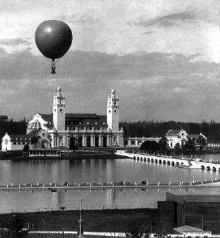
The Lewis and Clark Centennial Exposition, commonly also known as the Lewis and Clark Exposition, and officially known as the Lewis and Clark Centennial and American Pacific Exposition and Oriental Fair, was a worldwide exposition held in Portland, Oregon, United States in 1905 to celebrate the centennial of the Lewis and Clark Expedition. While not officially considered a World's Fair by the Bureau of International Expositions, it is often informally described as such; the exposition attracted both exhibits and visitors from around the world. During the exposition's four-month run, it attracted over 1.6 million visitors, and featured exhibits from 21 countries. Portland grew from 161,000 to 270,000 residents between 1905 and 1910, a spurt that has been attributed to the exposition.

Northwest Industrial Area is an almost entirely industrial neighborhood in the Northwest section of Portland. According to the Portland Bureau of Planning, it "is one of the few remaining large urban industrial districts in the United States" and "one of the premier heavy industrial districts in the Pacific Northwest". It borders the neighborhoods of Linnton on the north, Forest Park on the west, the Northwest District on the south, and Cathedral Park, University Park, and Overlook across the Willamette River on the east.

Dexter is an unincorporated community in Lane County, Oregon, United States. It is located near Dexter Reservoir, a.k.a. Dexter Lake, a reservoir of the Middle Fork Willamette River along Oregon Route 58.
Tryon Creek is a 4.85-mile (7.81 km) tributary of the Willamette River in the U.S. state of Oregon. Part of the drainage basin of the Columbia River, its watershed covers about 6.5 square miles (16.8 km2) in Multnomah and Clackamas counties. The stream flows southeast from the Tualatin Mountains through the Multnomah Village neighborhood of Portland and the Tryon Creek State Natural Area to the Willamette in the city of Lake Oswego. Parks and open spaces cover about 21 percent of the watershed, while single-family homes dominate most of the remainder. The largest of the parks is the state natural area, which straddles the border between the two cities and counties.

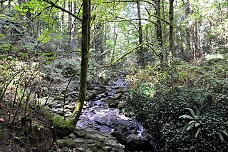
Balch Creek is a 3.5-mile (5.6 km) tributary of the Willamette River in the U.S. state of Oregon. Beginning at the crest of the Tualatin Mountains, the creek flows generally east down a canyon along Northwest Cornell Road in unincorporated Multnomah County and through the Macleay Park section of Forest Park, a large municipal park in Portland. At the lower end of the park, the stream enters a pipe and remains underground until reaching the river. Danford Balch, after whom the creek is named, settled a land claim along the creek in the mid-19th century. After murdering his son-in-law, he became the first person legally hanged in Oregon.

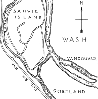
The Columbia Slough is a narrow waterway, about 19 miles (31 km) long, in the floodplain of the Columbia River in the U.S. state of Oregon. From its source in the Portland suburb of Fairview, the Columbia Slough meanders west through Gresham and Portland to the Willamette River, about 1 mile (1.6 km) from the Willamette's confluence with the Columbia. It is a remnant of the historic wetlands between the mouths of the Sandy River to the east and the Willamette River to the west. Levees surround much of the main slough as well as many side sloughs, detached sloughs, and nearby lakes. Drainage district employees control water flows with pumps and floodgates. Tidal fluctuations cause reverse flow on the lower slough.
The following is a timeline of the history of the city of Portland, Oregon, United States.
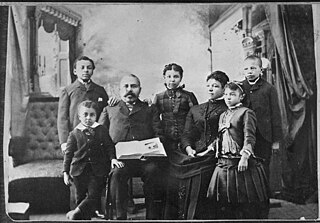
Danford Balch was a mid-19th-century settler in what later became the Willamette Heights neighborhood of Portland in the U.S. state of Oregon. He was born on November 29, 1811, in Colrain, Massachusetts, but spent his early years in Onondaga County, New York. In 1850, Balch moved west to Portland, and settled on a donation land claim of about 346 acres (140 ha) with his wife, Mary Jane, and nine children. A commemorative stone at Northwest 30th Avenue and Upshur Street marks the spot of the Balch homesite. A family named Stump, with whom the Balches quarreled, settled a nearby claim.
Tanner Creek is a small tributary of the Willamette River in Portland in the U.S. state of Oregon. Named after a tannery owned by one of the city's founders, it begins in what is now the Sylvan–Highlands neighborhood in the Tualatin Mountains west of downtown. In the 19th century the creek flowed on the surface, running northeast across the city, past what later became Providence Park and into a shallow lake and wetlands in what became the Pearl District, bordering the river.

Swan Island is located on the Willamette River about 4.5 miles (7.2 km) downriver from downtown Portland, Oregon, United States. Although presently connected to the Willamette's east bank, it existed as a river island under natural conditions.

Home Forward, established in 1941 as the Housing Authority of Portland, is a housing authority that serves Portland, Oregon, and nearby municipalities in Multnomah County, Oregon, United States. Home Forward maintains properties in Portland, Gresham, and Fairview.
African Americans in Oregon or Black Oregonians are residents of the state of Oregon who are of African American ancestry. In 2017, there were an estimated 91,000 African Americans in Oregon.
The following is a timeline of the history of Oregon in the United States of America.