
Frisia is a cross-border cultural region in Northwestern Europe. Stretching along the Wadden Sea, it encompasses the north of the Netherlands and parts of northwestern Germany. The region is traditionally inhabited by the Frisians, a West Germanic ethnic group.

A barn is an agricultural building usually on farms and used for various purposes. In North America, a barn refers to structures that house livestock, including cattle and horses, as well as equipment and fodder, and often grain. As a result, the term barn is often qualified e.g. tobacco barn, dairy barn, cow house, sheep barn, potato barn. In the British Isles, the term barn is restricted mainly to storage structures for unthreshed cereals and fodder, the terms byre or shippon being applied to cow shelters, whereas horses are kept in buildings known as stables. In mainland Europe, however, barns were often part of integrated structures known as byre-dwellings. In addition, barns may be used for equipment storage, as a covered workplace, and for activities such as threshing.

Aurich is a district (Landkreis) in Lower Saxony, Germany. It is bounded by the North Sea, the districts of Wittmund and Leer, and the city of Emden.

The East Frisian Islands are a chain of islands in the North Sea, off the coast of East Frisia in Lower Saxony, Germany. The islands extend for some 90 kilometres (56 mi) from west to east between the mouths of the Ems and Jade / Weser rivers and lie about 3.5 to 10 km offshore. Between the islands and the mainland are extensive mudflats, known locally as Watten, which form part of the Wadden Sea. In front of the islands are Germany's territorial waters, which occupy a much larger area than the islands themselves. The islands, the surrounding mudflats and the territorial waters form a close ecological relationship. The island group makes up about 5% of the Lower Saxony Wadden Sea National Park.
Leer is a district (Landkreis) in Lower Saxony, Germany. It is bounded by the city of Emden, the districts of Aurich, Wittmund, Friesland, Ammerland, Cloppenburg and Emsland, and by the Netherlands.

East Frisia or East Friesland is a historic region in the northwest of Lower Saxony, Germany. It is primarily located on the western half of the East Frisian peninsula, to the east of West Frisia and to the west of Landkreis Friesland.

The Frisian Islands, also known as the Wadden Islands or the Wadden Sea Islands, form an archipelago at the eastern edge of the North Sea in northwestern Europe, stretching from the northwest of the Netherlands through Germany to the west of Denmark. The islands shield the mudflat region of the Wadden Sea from the North Sea.
Greetsiel is a small port on the bight of Leybucht in western East Frisia, Germany that was first documented in letters from the year 1388. Since 1972, Greetsiel has been part of the municipality of Krummhörn, which has its administrative seat in Pewsum. The nearest railway station is at Emden, about 15–20 kilometres (9.3–12.4 mi) away, and the two towns are linked by a bus service.

The German Bight is the southeastern bight of the North Sea bounded by the Netherlands and Germany to the south, and Denmark and Germany to the east. To the north and west it is limited by the Dogger Bank. The Bight contains the Frisian and Danish Islands. The Wadden Sea is approximately ten to twelve kilometres wide at the location of the German Bight. The Frisian islands and the nearby coastal areas are collectively known as Frisia. The southern portion of the bight is also known as the Heligoland Bight. Between 1949 and 1956 the BBC Sea Area Forecast used "Heligoland" as the designation for the area now referred to as German Bight.

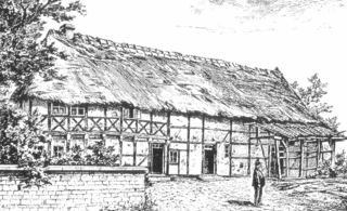
The Low German house or Fachhallenhaus is a type of timber-framed farmhouse found in northern Germany and the easternmost Netherlands, which combines living quarters, byre and barn under one roof. It is built as a large hall with bays on the sides for livestock and storage and with the living accommodation at one end.
A "Head-Neck-Body farmhouse" or Head-Neck-Rump farmhouse is a typical Frisian farmhouse. It consists of a residence and a kitchen placed in line in front of a big shed. A striking fact is that the residence was never built in the centre front of the shed – this has to do with the origin of this type of farmhouse from a smaller type of farmhouse that has now disappeared. This original Old Frisian longhouse consisted of a residence with a cattle shed immediately behind it. The harvest was stacked in the attic or in open barns which were logically located near the livestock shed.
The Middle German house is a style of traditional German farmhouse which is predominantly found in Central Germany.

A housebarn is a building that is a combination of a house and a barn under the same roof. Most types of housebarn also have room for livestock quarters. If the living quarters are only combined whith a byre, whereas the cereals are stored outside the main building, the house is called a byre-dwelling.
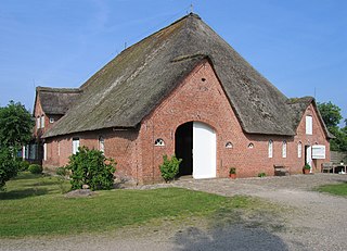
The Geestharden house, also called the Cimbrian house, Schleswig house, Slesvig house or Southern Jutland house due to its geographical spread in Jutland, is one of three basic forms on which the many farmhouse types in the north German state of Schleswig-Holstein are based. The other two basic designs are the Gulf house and the Low German hall house. By far the best known variant of the Geestharden house is the Uthland-Frisian house, which is also referred to as the Frisian house (Friesenhaus).

The Uthland-Frisian house, a variation of the Geestharden house, is a type of farmhouse that, for centuries, dominated the North Frisian Uthlande, that is the North Frisian Islands, the Halligen and the marshlands of northwest Germany.
The formerly independent village of Wiegboldsbur in East Frisia in North Germany has been part of the municipality of Südbrookmerland since the regional reform of 1972. Wiegboldsbur is a ribbon development (Reihensiedlung) and lies on the Großes Meer about 10 km northwest of the sea port of Emden. The parish chair is Bernhard Behrends (SPD).
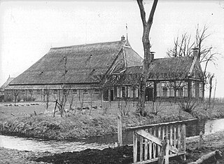
A Haubarg, rarely also Hauberg, is the typical farmhouse of the Eiderstedt peninsula on the northwest coast of Germany and is a type of Gulf house. It emerged in the late 16th century when West Frisian immigrants brought with them the Gulf type of farm building and it was to continue to be used until the late 19th century as a farmhouse. In the Netherlands these houses are called stolpboerderij.
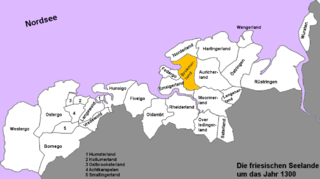
The Brokmerland is a landscape and an historic territory, located in western East Frisia, which covers the area in and around the present-day communities of Brookmerland and Südbrookmerland. The Brokmerland borders in the east on the Harlingerland and in the north on the Norderland. The historic Brokmerland is usually written with only one "o". Occasionally one also finds the spelling "Broekmerland", while today's communities have chosen to spell the name with a double "o".

A byre-dwelling is a farmhouse in which the living quarters are combined with the livestock and/or grain barn under the same roof. In the latter case, the building is mostly called an housebarn.

The Lorraine house or Lorraine farmhouse is a vernacular, agricultural house type found in Lorraine in France and the western part of the Saarland in Germany. It is a byre-dwelling, with the living and working quarters of a farming business combined under one roof. Lorraine houses developed after the devastating wars of the 17th century and took the place of individual scattered farmsteads.


